Since we left Mission San Antonio on Friday morning, we've traveled a difficult 38 miles to Arroyo Seco Campground. We have been here for two days resting and have not yet visited Mission Soledad. We thought that this might be a good time to tell you a little bit about our bicycle trip.
From Mission San Antonio we followed Del Ventura Road north out of Hunter Liggett Military Reserve and into Los Padres National Forest. Soon after leaving the military reserve we saw some very large rock formations on the left side of the road. We had heard that in some of these areas it is possible to see signs of the Salinan people and other Native American tribes that used to live in the Santa Lucia Mountains. In a cave we found a place where many small holes had been carved into the rock floor. These holes were probably used by the Salinans to grind corn and other grains in "mortar and pestle" fashion.
About 6 miles after the cave the paved road ends and a small dirt road continues up into the Santa Lucia Mountains. A few weeks before our trip we called the Monterey Rangers to ask about the condition of this road. . The woman that we talked to said that this road was closed to cars, but that we could probably get through with our bikes.
As we traveled this road we saw many signs of the rains of this past winter. Even though we were traveling 2,000 - 3,000 feet up in the mountains parts of the road were sandy. The sand on the road was probably fine dirt and silt that the rains had washed down off the mountains. Later we came to a section of road covered by large logs and what looked like driftwood. We think that the flooded river destroyed many trees higher up in the mountains and carried them down to this spot. Since the road was very rough in these section, Brian decided to take the computer out of his pannier (bike touring bag) and carry it in a backpack. Using a backpack allowed Brian to protect the computer from rough bumps and jolts. Jolting the computer too much can damage its hard drive.
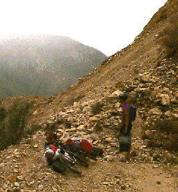
When we had traveled about 10 miles along the dirt road we saw a terrible sight. An enormous landslide had washed away part of the mountain and had taken the road with it! In order to cross this landslide we had to completely unload our bikes and carry each piece of our equipment over the dirt and rocks. Before we did this we checked carefully to make sure that no more rocks could tumble down on our heads! A little trail had been made on the landslide where other people had climbed over. This trail made it possible for us to carry our bikes over safely.
After crossing the landslide we rode another 6 miles through mist and light rain. Soon the road descended out of the mountains and we arrived safely at Arroyo Seco Campground.
--Brian and Matt
 Return to
the Report Index
Return to
the Report Index