
| Main Page | Diary | Leaves | Stats |

619. Skyline-to-the-Sea Trail (05/24/08)
Hikers (15): Brian C, David, Devin, Diane, Eric F, George, Helen, Iyad, Jeff, Nani, Paul, Ross, Sabine, Steve, Tiffany D
Distance: 30 miles
Rating: 5 difficulty, 9 beauty
Park info: Castle Rock State Park in the Santa Cruz Mountains
Write-up by Peter and Steve -- Pictures by Peter
My knee had been in bad shape all week, so I had to "lead" this hike the same way that politicians lead troops into battle -- from a safe distance. The plan was to do the Skyline-to-the-Sea trail in reverse, i.e. starting at the beach and going uphill all the way.
I showed up at the crack of dawn to help with the car shuttle duties from Skyline down to Waddell. Ross, Jeff, and myself loaded up the cars with eager INCHers and we were off. I had given the drivers printouts with complete directions, but they or their navigators (Nani, George) decided to ignore them completely, and so we ended up driving an extra 15 miles to get to the beach, giving me plenty of time to listen to Helen and Diane talk about their recent weight gain/loss experiences. I was looking for a suitable spot to drive off a cliff, but no luck. I think Jeff was inspired by the traditional Memorial Day Indy 500 race -- I never knew a van could move like that on hairpin turns. I guess he just wanted to make sure his passengers were awake for the hike -- mission accomplished!
1, 2, 3 ... INCH!
It was nice and cool down by the ocean, with a few sprinkles of rain as we arrived. Fortunately, the recent Summit Fire in the Santa Cruz Mountains had not affected this area, so the hike was able to proceed as planned. A quick INCH cheer, and they were off!
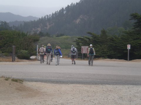
As for me, I waited a few minutes to see them disappear into the woods, then began the journey back home. I briefly got lost and did a big loop of Stanton Road and found myself back on the PCH after about half an hour of driving. Seeing as I was not too far from Santa Cruz, I went into town for a nice breakfast, then had a leisurely drive up Hwy 17 and went home for a 3-hour nap. This is how all hikes should be.
After a nice afternoon playing with Maddie, I went back to Skyline to see how the troops were doing. I got there around the 10-hour mark to find the parking lot pretty empty. Most of the crew and finished the hike and taken off already, leaving behind a handful of cold souls who were waiting for their carpool partners to show up.
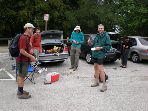
There was some confusion about whether or not Jeff was planning to hitch a ride from Waterman Gap due to a gimpy ankle, so George and Ross took off to Waddell to retrieve their cars without him. Nani got roped in to drive Jeff all the way down to the beach to get his van. Kill the messenger!
I'm happy to report all completed the 7400-foot climb in good time and good spirits (see details in Steve's table below). I look forward to doing this hike myself fairly soon, and I'm sure warmer weather will make it a lot tougher. Special thank you to Bunny and Glen for dropping by with brownies and goodies for the gang. Happy 12th anniversary, INCH!
Epilog: Nani and Jeff tried to take my original directions when doing the return trip but found out from the park rangers that this route is incorrect, and goes along some private roads that are fenced off. Blame Google!
Seems like someone who actually did the hike should say something. . .
We had three cars take three different routes to the start of the hike. I was in the far back of Jeff's van, which turned into one of the most frightening rides of my life. We stopped once to decide which way to go. Nani, who had stolen the front [navigational helm] seat despite my call of "Shotgun", declared with full conviction that we should not follow Ross's vehicle, which in turn convinced Peter's carpool ahead of us to also turn around. Seconds later, Magellan Jr. was doubting his decision. Worst still, Peter was now behind us, allowing Jeff to put the pedal to the metal! Jeff 'Andretti' Fisher flew down the road in this top-heavy van, riding the dots most of the way. I just closed my eyes and hoped for the best when Jeff took a quick right to head toward Bonnie Doon. Suddenly we are going uphill and away from the coast. I was sure we were going the wrong way until I saw Empire Grade Road. "Hooray", I said, "take a left, as it goes to HWY 1." But no, we continued onward up Ice Cream Grade. . .and eventually got to Bonnie Doon. . .after many harrowing curves. Jeff said, "I don't know which road it is", so we just start barreling down some road toward the coast. Amazingly, it all worked out and we were the first ones there. All in all, while I will never get in a vehicle with Jeff again, he absolutely took the best route.
I was already exhausted from expending so much adrenaline on the way there, but happy to still be alive. We waited for the other two carpools to show up (and everyone to visit the restroom). Soon we were assembled and off. . .
Peter can't hike worth a damn, but he makes a fine map set. As we went up McCrary Ridge, I was guessing people wouldn't notice the highlighted (on the map) trail to McAbee Pt (a.k.a. Wheat Pt), which is a half-mile detour each way after the Howard King turn-off. But as I was coming down from the Point, there was George and Sabine coming up, followed by Brian C and Helen (who was ready to turn around when she saw me because, of course, she hadn't actually read the map and was just following people), then Iyad et. al. But where was Ross!? (Turns out he was skulking around in the bushes somewhere, but I would assume for the next several hours that he had skipped the overlook and was ahead)
Well, that was the last time I saw any INCHers on the hike. From there, it was a long downhill to the STTS trail. After a quick visit to Berry Creek Falls, it wasn't too long until I was near the HQ. The air was so cool that I decided to skip a visit for water. As it turned out, 3L was just enough for the whole hike.
The rest of the hike was lots of redwoods and the occasional backpacking party coming the opposite direction from Waterman Gap. The hike back up to China Grade Road was pretty gentle. I'd almost say that the whole hike is easier in this direction, including the McCrary Ridge section, but I know this can't be true. Still, it was not nearly as bad as expected. Even the sections of the hike that were exposed had the benefit of an overcast sky.
As several people mentioned, Peter's notes say the last section of the hike is uphill all the way. But that's not true, which was a relief. A mile short of the end I was tempted to take Nutmeg Trail, which would make the hike slightly longer (but would be something new), but decided against testing the unknown trail after 29 miles (plus I was now out of water).
As I crossed Skyline Blvd, Ross was nowhere to be found. I sat down on a bench and took a load off. 15 minutes later, Ross showed up, and kindly offered some chips and beer. I was hungrier than I realized, polishing off a partial bag of chips in no time. It was cold enough, however, that the beer took a while longer. Soon, I was looking dorkier than usual, sitting cross-legged, wrapped in a cheap (orange) plastic poncho, desperately trying to stay warm in the constant breeze. My warmer gear, of course, was locked away in one of the carpool cars. George showed up and had the bright idea of sitting in his car. Awesome! Enjoyed another beer, and some more chips with humus. This is living.
The food kept coming. Out of nowhere appeared Skyline-locals Bunny and Glen with a cache of brownies and drinks, in celebration of the INCH anniversary. By then we had a fair number of people, so the brownies were going fast--thanks guys! Later, Peter would show up and, although Bunny and Glen had left, managed to enjoy the last anniversary brownie. We also ate some of Nani's Indian crunch stuff, which is great--by the time we all left, I had easily consumed twice as many calories as used during the hike. Happy 12th anniversary to INCH!
For those looking for a time estimate of this hike, we all finished between 8 and 10.5 hours.
Hike started at 7:17 am.
| Hikers | Finish(pm) | Hike Time |
|---|---|---|
| Steve | 3:15 | 7:58 |
| Ross | 3:30 | 8:13 |
| George | 3:45 | 8:28 |
| Sabine | 4:03 | 8:46 |
| Brian C | 4:13 | 8:56 |
| Helen | 4:25 | 9:08 |
| Nani, Devin | 4:31 | 9:14 |
| Iyad | 4:33 | 9:16 |
| Jeff | 5:11 | 9:54 |
| Diane M | 5:30 | 10:13 |
| David | 5:31 | 10:14 |
| Paul | 5:34 | 10:17 |
| Tiffany D, Eric F | 5:55 | 10:38 |
Milestones:
Diane's 60th leaf
George's 180th leaf
Ross's 170th leaf
![]()
![]()
Pages maintained by Steve Walstra,
Peter Saviz, and
Russell Gee.
©2026 Intrepid Northern California Hikers