
| Main Page | Diary | Leaves | Stats |

102. Five Finger Falls (01/16/99)
Hikers (7): Beth, Eugene, Fiona, Jane M, Peter, Russ, Steve
Distance: 16 miles
Rating: 3 difficulty, 9 beauty
Park info: Forest of Nisene Marks State Park in Aptos
Write-up by Peter
Finally -- a new hike!!!
Our good friend Ram (who I should also mention did not show up for the actual hike) had told us about the Forest of Nisene Marks State Park, adjacent to the quaint little town of Aptos, just south of Santa Cruz.
The web had informed us that a logging frenzy had taken place in this area between 1883 and 1923, but now the forest was healing and offered many trails for exploring its beauty. The 10,000 acre park was largely undeveloped, and with a maze of ridges, canyons, and watersheds was described as a "hiker's paradise". Not only that, but the Brittania Arms Pub in Aptos was located very close to the park entrance! How could we pass it up?
We arrived in Aptos and found the park pretty easily (turn left just past the Brit, just as the directions had said). It was one of those parks where the actual entrance is quite a ways inside the park, so we drove for a few miles under the shade of the mighty redwoods towering overhead. Some parts of the road looked like they hadn't seen the sun in years. It was like a prehistoric land that time forgot. Very beautiful!
Jane had a visitor in town and brought her along. Hmmmmmmmm, bringing a newbie along on a long trail none of us had ever been on before .... sounds like the perfect INCH recipe for disaster. I guess she'd done something to piss off Super Jane and this was payback time!! More on that later -- now, it was time to hike.
1, 2, 3, ... INCH!
The first couple of miles were pretty flat, as we walked along a wide fire road that followed Aptos Creek. As it was a chilly day in January and the trail was mostly shaded, we were walking at a pretty good pace in order to keep warm. Boy, I could have used a hot cup of coffee at that point.
Eventually the trail narrowed, and the bikers and joggers disappeared. Now it was beginning to look more like a hike! The trail led us downhill to the creek. It looked like there was no choice but to cross it. None of us had a good map of this place, but we knew that we had to follow this creek to end up at the falls.
There was no clear crossing point, so we started to spread out. I found a decent place to cross and made it across the creek, went up a little further, crossed over and back again, but finally ended up in a dead end. The vegetation was pretty overgrown along both banks of the creek, so it made it hard to see what was up ahead. Dang! Time to backtrack.
By the time I made it back to the starting point, Esteban and Muffy had
disappeared but the rest of the crew were still floundering about.
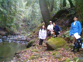
Time to take a picture!
Esteban and Muffy hadn't returned yet, so it seemed that they were on trail. I decided to follow their lead. The rest of the gang did not seem to be too enthusiastic. I knew Rusty was not too keen on get his feet wet, so I figured this was going to take some time. Fiona was already talking about having to catch a plane that evening. Less than an hour into the hike and she was already regretting it. Yes!!! We have another victim!
I forged on through the forest ... the trail zigged and zagged through thick brush and was hard to follow in many places. If this place had been decimated by logging, it sure wasn't obvious to me! Fortunately, some of our predecessors had marked parts of the trail with cairns, so it wasn't too bad.
A little further up, the trail crossed over the creek again and then became wider. Finally, a chance to to pick up the pace. The trail led gently uphill for the next mile or so, overlooking the creek down below, until finally reaching a fork. The left fork went towards Sand Point Overlook (we'd planned to take this trail as part of the return trip). The right fork led back down through the brush and towards Five Finger Falls. No sign of anyone in front or behind me .... onward to the falls!
I kept walking along the side of the creek. The creek was pretty wide at this point, and I was hoping that I hadn't missed a fork and was heading in the wrong direction. The crappy map showed that the creek did fork a few times, but all the forks hit dead-ends at about the same time. So the worst-case scenario was that I'd have to back-track and take another fork.
I kept going, and before too long found myself walking through a field of bamboo! What the heck? Was I in the Far East or something? Looking at the map, I found that this part of the park was named China Ridge. Made sense ... I kept going.
Another half hour passed .... I had not seen any cairns for a while, but I was still making my way along the banks of the creek, so I figured I was on the right track. The banks were getting steeper and creek was getting narrower, so I assumed I must be getting closer to the falls.
The footing underneath was getting muddier and slicker by the minute. I had to grab plants to keep myself from sliding down the embankment, but I could see fresh footprints in the mud, so I knew that this part was traversable. A little further up, I was able to finally hear the sound of the waterfall. Yes!
As I made my way through the brush to the falls, I could Esteban and Muffy up ahead. It looked like they hadn't been there that long and were trying to find a good place to sit. Ahh, finally .... I threw down my backpack and took a load off.
I sat there enjoying the view while eating my peppered turkey sandwich. This is what it's all about! Esteban seemed to think the waterfall was too small to justify the trek to get here. I admit it wasn't Niagara Falls, but to me it was worth the trip. The only problem was that a tree had fallen over the top of the falls and was partially obscuring the view. Other than that, no complaints.
A few minutes later, Eugene showed up as well. No sign of the others. We waited a little longer and gave Eugene a chance to rest, but since it was pretty cold, we didn't want to hang around too long.
We began the trek back, slipping and sliding through the brush, back up the China Ridge, until we ended up back at the fork. We saw the others had put down an arrow pointing along the other trail. They had skipped the best part of the whole hike! I figured Jane and Fiona had to shortcut in order to get back early, but what was Rusty's excuse? The bastard! I was tempted to give him a black leaf for this, but since he was ostensibly "protecting" the women (and I knew he didn't like water), I let it slide.
We followed their lead and decided to turn on the heat in order to catch them. It actually worked! We caught up to them before they reached the overlook (they had stopped for lunch along the way as well, so it wasn't like we were that fast!).
The final mile to the overlook as uphill all the way (as you would expect for an overlook). By now we were all pretty damn tired and we were starting to drag. But, we finally made it to the top. Whew! There was a nice view from up here. Time for a snack -- good thing I'd brought enough food. I seemed to be burning it up pretty good today!
After a rest, we began to head back. The road back was all fire road. The good news was that it would all be downhill and we probably wouldn't get lost. The bad news was that mountain bikes kept whizzing past us, but for the most part everyone was pretty good about sharing the road and there were no ugly incidents.
It seemed to take forever to get back -- it was almost dark by the time we reached the cars. I guess 16 miles in the woods is a respectable distance. And now it was time for the reward -- beer, darts, and food at the Brit!
Milestones:
Fiona's 1st leaf
![]()
![]()
Pages maintained by Steve Walstra,
Peter Saviz, and
Russell Gee.
©2026 Intrepid Northern California Hikers