
| Main Page | Diary | Leaves | Stats |

23. Murietta Falls (02/01/97)
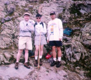
Hikers (4): Eugene, Peter, Russ, Taylor
Distance: 12 miles
Rating: 5 difficulty, 10 beauty
Park info: Ohlone Regional Wilderness south of Livermore
Write-up by Peter
Prior to the hike, we figured it could not possibly be as tough as our original trip to visit the Ghost of Murietta (see Hike #7). First, the temperature was much cooler. Second, we knew that we had to take gallons of water. Third, we now had a bunch more hikes under our belts and knew what to expect on this trail.
The discussion about the effect of the temperature led to a modification
to the Hiking Factor that we had previously defined (see
Hike #17). The revised Hiking Factor is defined as:
where the Temperature Factor is defined as:
| 0.02 * (T - 75) | for T > 75 | |
| Temperature Factor = | 0 | for 45 < T < 75 |
| 0.02 * (45 - T) | for T < 45 |
In other words, the hike becomes 2% more difficult for every degree the temperature goes over 75 degrees or under 45 degrees (which we have not yet experienced, thankfully).
On this scale, we were expecting the return to Murietta Falls to be about 50% easier than our original trip, going on temperature difference alone. Nonetheless, we still prepared for the worst, and each took along at least a gallon of liquids. We also set out earlier than usual, so we'd be back well before dark. Canteen Boy took along a flashlight anyway, just in case!
We took a shortcut to Livermore and picked up lunch at Lucky's. We had been skeptical of the quality of their deli sandwiches, but we were pleasantly surprised. The sourdough rolls were great and the deli lady packed a lot of meat into them. All right!
We arrived at Del Valle Reservoir and drove straight to the parking area. Unlike last July 4th when we had to park a mile away and take a shuttle bus, the parking lot was deserted. In fact, we saw a sign stating that the parking lot would close early if there were not enough visitors there, so we drove back and parked outside the gate.
The air was cool and misty - perfect hiking weather. Unlike last time when the hills were brown and dusty, this time they were covered with a brilliant green blanket due to all the recent rains. We were looking forward to actually seeing some water in Murietta Falls.
The first mile up to the sign-in point was an uphill slog through some pretty slippery mud and around some fallen trees and rock slides. This is what we call shiggy (thanks Hash House Harriers -- on-on!). The temperature may have been perfect for hiking, but the Ghost of Murietta would try to make it tough on us by providing lots of shiggy! But we were not deterred and even though we knew there were steeper hills and major shiggy up ahead, we pressed on.
1, 2, 3, ... HIKE!
We arrived at the official trailhead and signed in just before 10 o'clock. First rest stop. I downed my first bottle of water. The next stretch was a grinding uphill mile through the slop to the first gate. Second rest stop. I downed my second bottle of water. After the last visit, I was taking no chances and was hydrating frequently!
Since we all had plenty of water, we didn't even stop at the tap and continued on up. About a half-mile further up, we were in the mist. Rusty was up ahead, followed by myself, with Taylor and Eugene lagging behind. Taking heed of mountain lion warnings, we waited for everyone to regroup and continued on together.
After this, the trail flattened out and it was clear sailing for a mile to Williams Gulch (except for some deep shiggy in a couple of points). As we began our descent into the gulch, we could hear the water down below. We also came across some killer cows grazing in the meadow at the bottom. As they saw the fear on Taylor's face, they scampered off to higher ground. Mooooooooooo!
Compared to the little trickle of water at the bottom of the gulch on our last visit, this time it sounded like a raging river. I had figured this might be the case and had wondered if we would even be able to cross it and whether we would have to turn back. Well, its bark was worse than its bite. As we got closer, we saw that the river was still pretty shallow and easy to cross by stepping on some rocks.
The gulch was beautiful. The sound of the creek surrounded us on all sides and drowned out all other noise. We stopped to take some pictures with a couple of small waterfalls in the background.
After a quick rest (I finished my third bottle of water), we started up the Wauhab Ridge. Rusty pressed on ahead with everyone else in tow. The ground on this side on the gulch was firmer and more gravelly, so our fears of major shiggy were unrealized. As we wound our way up, we could hear the cows on the opposite side of the gulch. Mooooooooooo!
We went through the switchbacks pretty quickly and made it to the gate at the top for our next rest stop. Time for the traditional snack of carrots at the Wauhab Ridge gate. I finished my fourth bottle of water. By now, the effects of over-hydration were being felt and my breaks to "water the plants" were becoming more and more frequent, but at least I was not the only one. Not a pretty sight!
The next part of the trail was fairly steep and we noticed our pace slowing down. We made a pit stop at the Schlieper Rock, then pushed up past the spot where we had seen the old-timer on our last trip, past the spot where we had abandoned Eugene for the mountain lions, past the salt licks (which had been washed away), and up to signpost 36. After that, it was a quick mile over to Jackson's Pond and down to the falls.
As we walked past the tree where we had stopped for lunch on the last trip (and where Taylor and Camy had refused to go any further), Eugene's leg suddenly cramped up and he fell to the ground, grabbing his twitching leg. The Ghost was not giving up his turf so easily!
After abusing Eugene for a few minutes, we continued on. We could hear the sound of rushing water as we approached the falls. The falls are off to the side of the trail, but Rusty had charged ahead and missed the turnoff, so we had to call to him to backtrack up the hill. High Bone Density!
We scrambled the final few feet over some rocks and down to the water, each
picked a spot and settled down for lunch. Those meaty sandwiches tasted
good! Unfortunately, I dropped the cap off my bottle of Gatorade
and it went bouncing down the rocks and landed in the water. There it sat,
bobbing up and down in a little "sweet spot" at the top of the falls,
just out of reach, but out of the path of the water cascading down to the
bottom. Damn! Well, you know what this means -- a return trip in the
dry summer months to retrieve it! Just as Rusty was abusing me for
littering, he dropped his own bottle cap too, except this time it went
over the falls and down into the valley below. High Bone Density!
It was pretty chilly up there, so we didn't stick around for long. Eugene's legs were hurting, so the first part of the return trip was pretty slow. After a while, he warmed up and we were able to continue at a decent pace down the ridge and back into the gulch. We rested briefly at the bottom of the gulch and then made the push up the other side and back down to the car. Downhill shiggy!
In addition to frequent bathroom breaks, I stopped a half-dozen times to pick up random bits of trash and ease my guilty conscience about the bottle cap incident, and arrived at the bottom with pockets full of wet tissues and other assorted goodies. The round trip from the car up to the falls and back had taken exactly six hours -- not bad!
Despite Rusty's dismissal of this hike as a "Level 4 with a temperature factor", it did take its toll on us. Eugene had bleeding nickel-size blisters and was in major pain the next day. Taylor was hobbling about for a day and a half and Rusty and I were also a little sore. It had been a kinder, gentler Ghost on this visit, but he knew he would get the last laugh when we came back for more punishment in the summer.
![]()
![]()
Pages maintained by Steve Walstra,
Peter Saviz, and
Russell Gee.
©2026 Intrepid Northern California Hikers