
| Main Page | Diary | Leaves | Stats |

335. Mt. Diablo (West) (08/16/03)
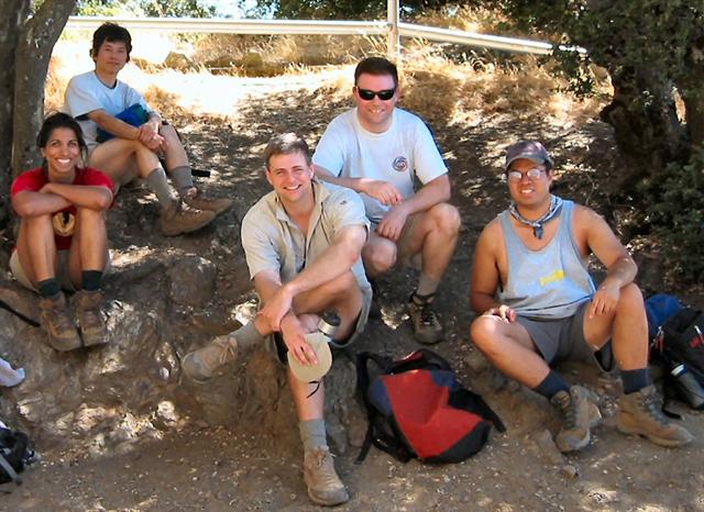
Hikers (9): David, Eugene, Hima, Kevin T, Peter, Russ, Steve, Sue, Taylor
Distance: 15 miles
Rating: 5 difficulty, 9 beauty
Park info: Mt. Diablo State Park near Walnut Creek
Write-up by Steve -- Pictures by Kevin
"And then there were three," said Peter, commenting on the remaining group as we headed out from the Castle Rock Regional Recreation Area. By that time, seven other hikers had already bailed out. But we must start this story at the beginning. . .
After a string of easy hikes, it was time for something harder. I planned a new hike: an assault on Mt. Diablo from the west side. It was about the same length as our usual Mitchell Canyon northern approach, but would start from a lower elevation. For even more spice, the return trail would feature a steep uphill finale with a high probability of off-trail hiking. [elevation profiles (to Diablo and from Diablo) to get a feel for the hike.] To add insult to injury, it was going to be over 90° F. This was looking like a level 5, but was advertised as a level 4 to be consistent with previous Diablo hikes.
Even after all the warnings, nine intrepid people turned out (plus a late tenth, who we didn't hear about until later). We met at Borges Ranch in Shell Ridge Open Space, which is separated from Mt. Diablo State park by a sliver of Diablo Foothills Regional Park. It's all very confusing, and a map of Shell Ridge at the beginning was indispensable since many of the Shell Ridge trails are not marked on the Mt. Diablo map.
1-2-3 INCH
After navigating a few trails (and a steep downhill section) through the first two parks, we ended up on Stage Road in Mt. Diablo State Park. A few feet down the trail, Peter suspiciously checked around and declared that we might actually be on the Mitchell Canyon trail! But he recanted when we saw "Castle Rock", a jagged rock formation that looks nothing like Mitchell Canyon. (It also doesn't look much like a castle)
I had put the locations of all the trail junctions in my GPS unit, so knew when to start looking for the places where we had to deviate from our current path. This was useful for finding our first uphill route, Sunset Junction Trial, which essentially connects two fire roads. Although not a long segment, it was a taste of what steepness was to come. At the top, we checked out the route elevation profile, which Dobby had brought along. It was clear that the rest of the hike was pretty much as steep as the Sunset trail. . .and we had five more miles of it.
Approaching 1000ft (where the trail crosses the North Gate road), the extent of the uphill becomes visible, shooting skyward as far as the eye can see. A message came through on the walkie talkie that Taylor was feeling a little sick and might turn around. Peter immediate looked a little sick himself: he didn't want to get a black leaf escorting her back! He started making contingency plans on how he could make some loops, or drive to the top and hike down with us (Ha! Like that would count). But ultimately Taylor hunkered down and kept on trucking.
After a couple thousand more feet of vertical, the front-running group of Russ, Hima, Kevin, David, and myself reassembled at the Juniper campground before making the final assault. Not too much later, we had all touched Diablo's peak, conveniently located inside the visitor's center. Speaking of the visitor's center, they now sell cold drinks and snacks--the $2 Sorbet bar was worth every cent on that hot day. About half an hour later, Peter ambled in, followed by Eugene. We waited for Sue and Taylor, who Peter assured us were just a quarter mile behind. We waited, and waited, and after another 30 minutes, part of the first group decided to start heading back down.
Just then, an SUV drove up with Taylor and Sue waving from the inside. They had gotten a ride! The story was that Taylor felt faint when crossing the road, and Sue stayed with her. They eventually decided to hail a vehicle to get to the top. Although the sign there said "0.2 miles" to parking lot, they were actually about half a mile and several hundred feet of altitude from the top. Close, but not quite. That's OK, though, so long as they hiked back down. . . .
Hima, Russ, Kevin, and I headed off since we had been there a long while. As it turned out, Sue and Taylor decided to get
a ride back as well ( city!), while Eugene, David, and
Peter came back down after us. We were down to seven.
city!), while Eugene, David, and
Peter came back down after us. We were down to seven.
I had warned everyone that we'd probably have to hike off trail on the way back. However, we ran into a hitch before that happened: part of the trail, although within the Diablo State Park, was off limits according to the small "Keep Out" sign. Since the dirt road was called "Government Road", I figured we had all paid for it, so climbed over the gate. There was no longer any signage in this part of the park, but at least I had the junctions marked in my GPS unit. Whoops--a little later on there were additional junctions along Government Road which didn't seem to be on the map (probably leading to secret government labs that were relocated from Mine Hill in Almaden). So much for that plan.
But no worries. We could clearly see the first (North Gate) of two roads we needed to cross. Only problem was that behind that road was a big ridge (which we'd have to climb most of the way to pick up another fire road). The most expeditious route appeared to be straight down the hill we were on and up the next one. As we headed down, we soon discovered that the weeds in this area have a weird sticky goo with a strong smell (perhaps products of that secret government lab). By the time we were down to the road, our legs were covered in the stuff, which made everything else stick to our legs.
From the road, we found a gate that allowed us to start trudging up the hill to what looked like a trail. But it wasn't a real trail, so I hiked up ahead to find the fire road we saw from the previous mountain. By now, people were getting tired, and a minor mob scene felt imminent. The heat and weed-filled off-trail hiking was taking its toll. I was getting worried that the "hot" heads would outnumber the "cool" heads, and all hell would break loose. Kevin was showing signs--he hadn't eaten breakfast or lunch. I tried to win him back over with a Cliff Bar. Although I didn't know exactly where we were, I did know where the cars were. GPS technology probably saved me from being lynched.
We still had one more road to cross, so was very happy to see it when the fire road looped around the current hill. Even better, I had a much better idea where we were since I could see a nearby private picnic area. Only half a mile (and one more hill) from the cars. Almost there!
When we got to the road, Russ unexpectedly pulled out his cell phone and called Sue for a pick-up. Although we were so near, he didn't want to hike another centimeter. It was a sad sight, made even sadder when Hima, Kevin, and Eugene joined him. But the saddest event of all was experienced by Sue, as four gooey-legged bodies crammed in her nice new car! And then there were three.
David, Peter, and I started up the last trail. It wasn't too steep for too long, and we finally ran across a sign which confirmed where we were. As I crested the hill, I could see Sue's car-o'-shame pulling out after depositing Hima.
When I got to the lot, Taylor looked none-the-worse for wear, having mostly recuperated. I started hiking to the next lot when I heard Eugene talking to Sue on the walkie talkie about coming back to the first lot. That sounded like a better plan to me. Looks like David made the longest trek with the extra 100 yards to get to his truck. Good job!
Upon arrival, Peter turned whiter than usual after he sat down--the last little bit almost did him in. Perhaps Russ was wise, but The Man still has his pride! Well, he had it for a while, until Taylor started pouring water on his legs to clean off the goo. The super-hot water (from being in a car trunk all day) scalded the poor Man's legs, making him shriek like a school girl. This provided several minutes of entertainment. [Useful tip: Taylor later discovered that rubbing alcohol cuts through the goo much better than hot water. This was probably much preferred by Peter over her original proposal to shave his legs]
In the INCH love-to-eat tradition, Sue's car (Russ, Sue, and me) stopped by a pizza joint on the way back for dinner. Although we were all starving, we still couldn't finish a large pizza among the three of us. Perhaps THAT's how exercise actually works for dieters? Whatever the case, pizza was a good end to a tough hike.
Addendum
The next week, Olivier told us that he actually came to Diablo
and attempted the same hike. He was late, so started after us, and eventually
ran out of water (Winnie wasn't there with supplies this time around), so had to turn around. We set a record low 30% completion rate: the Devil Mountain exacts a heavy toll.
Milestones:
Highest point in Contra Costa county
![]()
![]()
Pages maintained by Steve Walstra,
Peter Saviz, and
Russell Gee.
©2026 Intrepid Northern California Hikers