
| Main Page | Diary | Leaves | Stats |

357. Mauna Loa Summit Trail (11/20/03)
Hikers (6): Cal, David, Peter, Russ, Taylor, Tim
Distance: 11 miles
Rating: 5 difficulty, 5 beauty
Park info: Mauna Loa Volcano on the Big Island of Hawaii
Write-up by Peter -- Pictures by Russ
We'd taken the previous day off from hiking to do some kayaking and snorkeling (highly recommended!), so Cal had to make up for it by taking us on one of the most punishing hikes of all time. I have to say it was the closest I have ever come to death on an INCH hike.
The plan was to hike to the peak of Mauna Loa volcano, rising 13,000 feet above Hawaii. Hiking from the bottom to the top is a 3-day backpacking adventure. We decided to take the "easy way", and drive up to the radio station at 10,000 feet and hike from there -- an 8-mile round trip. Kuki wisely decided to skip the hike and go golfing.
With that in mind, we got to bed early and prepared to hit the road at 7 am. We knew it would be about a 3-hour drive to the trailhead because it involved going along some pot-hole filled dirt roads (which rental cars are not allowed on!).
Just before heading out, I decided to check Cal's map to see what we were in for. Turns out the 8 miles would just take us to the edge of the crater. To do to the summit would be an extra 5 miles round trip. Uh-oh! Undaunted, we headed out.
The road to the radio station was not as bad as I had imagined (certainly better than the back road to Hana), and we made it there by 10:30. We could already feel the effects of the altitude even though we were only at 10,000 feet. Sinus pressure, shortness of breath, slight dizziness ........ this was going to be tough! If we were smart (which we aren't) we should have come up here the night before and camped out in the freezing cold in order to give ourselves more time to adjust to the altitude.
1, 2, 3, ... INCH!
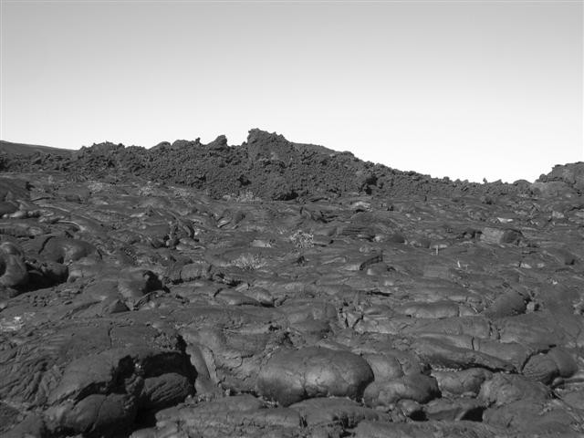
There was nothing pretty about this hike. It would just be 4 miles of grueling uphill through lava fields with treacherous footing and zero shade. Cal estimated we'd probably do about one mile hour on the uphill. We all scoffed at him, but it turned out he was exactly right. After half an hour of huffing and puffing, I looked down at my odometer and saw we had gone less than a half mile!
We pressed on ........ The Man was starting to pull away from the pack but was still in sight (you can see a clear mile ahead on the slopes of the volcano). We picked our way slowly up the mountain, guided by piles of lava rocks places there by previous hikers. My headache was getting worse and I had to keep stopping. I told the others to keep going and not wait up for me.
I finally made it to the first mile marker. Whew! This was going to be a long and brutal hike. I kept going, taking baby steps up the hill. The others were still in sight up ahead. I was feeling lightheaded and my headache was getting worse (reminded me of a few nights in the pub). Still over 2000 feet to go ...
The trail continued up the barren hill. I couldn't see any of the others, but from radio contact I knew they weren't too far ahead. I kept going. I past a couple more markers, then ran into a group of Japanese hikers. They looked pretty tired, but in good spirits. They told me they had just gone as far as the crater edge and then turned back.
I just kept slogging away and finally made it to the trail junction at the edge of the crater. I was exhausted. Looking over, I could see the crater spreading out before me, but had absolutely no interest in looking at it. I just wanted the torture to end. The others had made it there a few minutes before me and were eating lunch. I was hungry but I knew if I ate anything I would probably bring it right back up again. It was freezing up here, with a cold wind cutting through us like a knife. Time for the jacket and gloves.
We had successfully reached our original goal of making it to the edge of the crater, but we had to decide if we wanted to push for the summit. It was only 500 additional feet of elevation, but it was a 2.5 mile trail to get there. It would take us well over an hour, probably two. It was already 1:45, and knowing it was going to be dark by 5:30, we set a turnaround time of 3:00 and set out. Rusty had already set out and was about a half hour ahead of us at this point.
The trail was pretty flat, but the high elevation made it slow going. I had to stop and catch my breath every few steps. My heart was pounding, my fingers were tingling, my head felt like it was about to explode. There was no way I could make it to the summit. I'd be lucky to get back down alive. Cal radioed that he was at a marker that indicated 2 miles to go the summit. I decided to go as far as that marker and then turn back. After reaching the marker and touching the sign, I radioed the others that Taylor and I were turning back.
It was not a moment too soon. By now I had lost control of my legs and stumbling around like a punch-drunk fighter. The footing was treacherous and I was twisting my ankles at every step. I was pretty sure I was going to break a leg and have to be carried off the mountain. I was so woozy I couldn't even see straight. I had to sit down and rest. I collapsed on a rock, holding my head in my hands and gasping for air. I could tell by the look on Taylor's face that she was very worried. My backpack felt like it weighed a ton. If I was to have any chance of making it back, I would have to ditch it. Taylor grabbed it from me and strapped it on to her back. I made a lame attempt to be gentlemanly and take it back, but she would have no part of it.
We started back down the hill. I wanted to get off this thing as fast as I could. A few minutes later, the others radioed in saying they were also heading back. Rusty had made it to within a half-mile of the summit and the others had made it to within about a mile, but it looked like it would not be possible to go all the way and still make it back down before dark.
As we started dropping down in elevation, I started to feel a little better. I was still woozy and disoriented, but at least my heart wasn't pounding as much and I could breathe much more easily. The middle section of the way down was the best. The footing was good and we just cruised on down. After that, things got tough again. It was slow going over the sharp jagged rocks and I had to stop a few more times to try and clear my head. Cal and Rusty caught up with us about a mile from the end. Dave and Tim were about a half-mile behind. Cal didn't look too good either, but The Man was fresh as a daisy. That's why he's The Man!!
After an eternity, we finally made it back to the car. Thank God! I was freezing, nauseous, and dizzy. I stumbled into the back seat with all my hiking gear on (hat, gloves, boots, etc.) and threw the car keys on the ground. No way I could drive this thing! Others were feeling pretty lousy too, but it definitely seemed that I had got the worst of it. Taylor, who had been fine all day, was now also feeling nauseous -- some kind of delayed reaction. Right after we headed out, she made us pull over to throw up. I felt like doing the same, but nothing was coming up. I would just have to keep suffering .......
Cal tried his best to kill us this day, but we managed to survive. We learned some lessons the hard way, but it's all part of the adventure. I may go back and do this one again someday, but I will be better prepared. As for now, I think I'm going to spend the rest of the trip just lying on the beach!
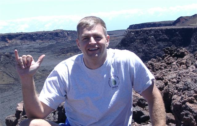
Not being able to bear an INCH failure, I flew out to Hawaii at the start of my sabbatical and summited Mauna Loa on 8/20/04 in the name of INCH (note shirt in picture below). Although I stayed in Hilo (closer to trailhead) and made an early start, I didn't start hiking until 9:50 am. It was an easy three hours to get up, followed by a brutal four and half to get down. I thought the lassitude was due to either the high altitude or the several pitchers of beer I had shared with some hostel-mates the prior night. Later I determined that is was most likely too much sun--I was beet red on parts of my arms and legs the next day. Guess those volcanic rocks were kind of shiny. This was my first use of hiking poles (for the descent)--my new poles looked like old poles after encountering all the sharp volcanic rocks.
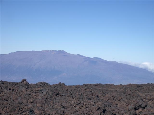
Compared with other volcanoes (and I've visited many), Mauna Loa is the most geologically attractive by far. It has interesting formations, rifts, lava tubes, asphalt-like lava fields; everything can be found just hiking up the Observatory Trail. It's much better than Peter's "rocks, rocks, rocks" caption above suggests.
Went over and 'hiked' Mauna Kea a couple days later (using the easy trail at the top)--besides lots of cinder cones, it doesn't have any of the cool formations of Mauna Loa. It may be 100 feet higher, but it's not nearly as interesting (unless you dig telescopes, in which case it is heavenly).
Milestones:
Tim's 20th leaf
![]()
![]()
Pages maintained by Steve Walstra,
Peter Saviz, and
Russell Gee.
©2026 Intrepid Northern California Hikers