
| Main Page | Diary | Leaves | Stats |

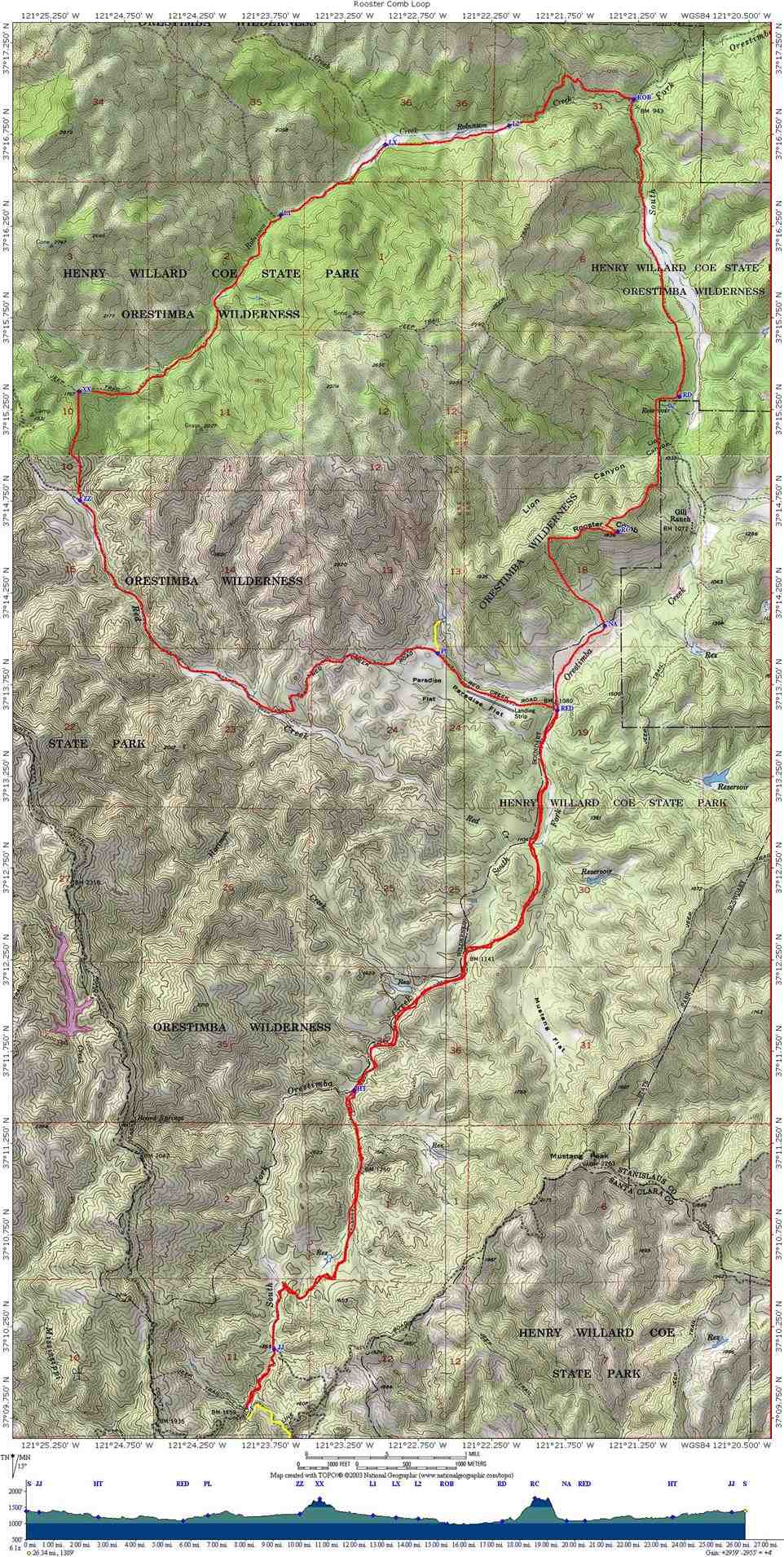
443. Rooster Comb Loop (04/23/05)
Hikers (10): George, Janice, Oliver, Padraig, Peter, Ramesh, Ross, Sparky, Steve, Tania
Distance: 27 miles
Rating: 5 difficulty, 9 beauty
Park info: Henry Coe State Park near Morgan Hill
Write-up by Steve
George's pictures [long gone]--relive the pain.
For years we talked about visiting the remote NE section of Coe, where our day hikes can never get us. We had kicked around the idea of applying for the Coe Backcountry Weekend, but it wasn't until Oliver pursued us about it that we decided to apply for permits. We figured on a 50% acceptance rate on the permits, and that about 10 people would be able to make it, so we applied for four permits. As it turned out, we got three permits for Saturday hiking and one for Sunday (which we canceled). Permits were probably easy to get this year due to the long rainy season.
There was a big snag on the permit, though--we had to be back at the parking lot by 5pm and out of the park by 6pm. To add insult to injury, the gates wouldn't open until 8am, meaning we'd likely not be able to start until 9am, giving us eight short hours to hike 27 miles (originally, we were considering a 35 mile trek to Mt. Stakes). This would require hiking 3.375 miles per hour for 8 hours straight! The only good news was that a plot on a topo map revealed the hike to be pretty flat. Peter and I were a little skeptical about it being easy though--Coe is never easy.
After pointing out all the constraints, 17 people still signed up (and more signed up later). I sent out a follow-up letter to encourage everyone to estimate how fast they could hike, with the goal of ensuring that everyone would be able to do it. It would be a catastrophe if one (or more) of the carpool cars were locked in the park overnight! My suggestion that people might not be able to do a hike went over like a lead balloon, but it did ultimately shrink the number to a manageable 12 people. Don't kill the messenger!
Carrisa and Chester bailed in the morning before the 6:30am carpool, supposedly because they were worried about sloppy trails from the rain the previous night (Carissa had that "just woke up" sound in her voice, though). Rain was forecast for the hike as well. We showed up early to the queue in front of the gate, and were hoping to get in an early start (like 8:45am). The rangers were worried about the roads going in, but as it turned out, the roads were fantastic, so it wasn't clear what the fuss was about. However, it was clear that we were screwed, because by the time we were out of the cars and moving, it was already 9:30am. There was no way everyone was going to be able to do 27 miles in 7.5 hours!
One bad omen: several people had brought overnight gear, just in case they were trapped in the park.
Due to the late start, I "called" a new hike: up to Rooster Comb and back. It was a shorter hike, about 16 miles, with the option to go farther to Robinson Mountain.
1-2-3 INCH!
We all took off from the start, pumped up from all the anticipation. Several people had said they didn't sleep well because they were thinking about the hike (and the early start time). We started a mile south of the Orestimba Corral--farther than all the overnighters, who had all day to hike. By the time we reached the first major junction (Red Creek Trail), I had convinced myself that I could still finish the whole loop by 5pm. I figured Ross could do it, but wasn't sure about anyone else. I strongly advised everyone to do the Rooster Comb, and radioed back that anyone still behind should definitely do Rooster Comb. Sparky told me later that this irked her so much she almost did the whole loop to spite me! INCH is a contentious bunch.
To make a long story short, only Peter and Sparky took my suggestion (and Peter mostly did that because he missed the Red Creek turnoff). The other seven figured they could make it (at least by 5:30p). We didn't really spend much time discussing it, because there was no time to waste!
The meadow (Paradise Flat) along Red Creek Road was amazing--and nice and flat. It wasn't too much later, however, that we were crossing Red Creek back and forth (just as we had done Orestimba Creek for the previous six miles). This was no big deal, but slowed things down a little. George and Ramesh were right behind me, with Ramesh running occasionally--I was sure he was going to be doomed later when he ran out of steam. . .This is roughly when George sprained his ankle, and just kept on going! {Price for this: 1.5 weeks out of service--hard core!}
We eventually made it to the Robinson Creek Trail offshoot, and this is when things got complicated. The trail goes steeply up a hill and, well, there isn't much of it left. Like all the other trails, it is the remanent of an old jeep road, but this one hasn't been used in a very long time. Substantial pine trees had grown right in the middle of some sections. However, there was a different type of weed growing along the old road, and it made it reasonably clear, including one sharp turn near the top (where I had the benefit of a GPS to confirm). I called back about "the turn" to George, who absolutely couldn't seem to get my message clearly (and was too far back to see me waving at him). A bit later, I heard him call back the same instructions to people behind him, so I knew everything was OK.
The trail went up a ridge (the only major climb on the whole hike) and then dropped into Robinson Creek proper. I followed the creek for a while on what seemed like a faint trail, and then noticed that the creek was too narrow to have ever been a road. I climbed up the left bank and found the jeep trail again--that sped things up considerably. I called this back to George, and this time he got the message.
That road eventually dumped down into the creek, and opened up considerably into a broad plain. Again, there was much criss-crossing of the creek, where I slightly sprained my ankle on a pine cone (to be repeated many times afterwards--it was a pine-cone minefield). Coe was kicking my rear as usual. The creek narrowed again and reached a point where a big bolder clearly blocked anything that could have been a road. Then I noticed a perfect slope rising out of the creek bed--the jeep trail went nicely up the side of the hill. It turned out to be the right way to go. I radioed this back, and went through several iterations with George, who was asking which side the boulder was on, etc. I later heard they missed it, and eventually backtracked to find it. This is the same spot where apparently Padraig enjoyed a long lunch (!), but found the correct trail and caught up with everyone else easily. This was also the last time I was in contact with anyone.
Reaching the Orestimba Road junction was a major milestone. I found somewhere to sit down, took off my boots, taped up my sprain, changed socks, and ate a Cliff bar--things were good. Flicked off a few ticks when I was done--this is about the third time the "ticks hang out on logs" theory was confirmed. Not too much later, I heard George radio that he and Ramesh had made it to the same junction. I tried to call back, but to no avail.
George had made a spreadsheet to allow calculation of approximate elapsed times that would be necessary to maintain the required pace. For the whole trip I had been comparing my stopwatch time to the target times scrawled on my map. I had suddenly started making very good time. . .and then realized my stop watch had stopped! D'oh! So I switched over to the clock time and realized I needed to pick up the pace to make it back by 5pm.
The rest of the trip was a blur, although I passed by the famed Rooster Comb formation, which is pretty impressive looking (but not very tall). I had planned to hike to the top, and thought it would be a bit shorter to go that way, but by the time I got there I had decided to skip it because my ankle might not like the steep descent.
On the way back down Orestimba Road (the way we had come up), I found many more side routes which avoided the creek crossings (but went up little ridges)--don't know how we missed them on the way down, but it made the hike a little faster coming back. This was the first time I started seeing people again--the whole hike had been secluded from Paradise Flat to around the Rooster Comb.
Stumbled back to the car at 5:02pm! Sparky and Peter were talking to the ranger, informing them that it was unlikely we'd be out in time. I figured they had been there for hours, but had only gotten back 30 minutes prior. They both had misadventures, with Sparky taking the "straight-up" approach to reach the top of the Comb (and finding it rather treacherous) and Peter taking the back-door route (and missing the turn, getting lost, but eventually finding his way up). We celebrated by drinking 3 out of 4 of Ross's beers!
George and Ramesh came next, followed by Ross (who had gone to the top of Rooster Comb), and finally Tania, Padraig, and Janice. But where was Oliver!? It was already after 6pm, so Ross, Tania, and I took a car down to the gate to try to keep it open. We passed by a ranger on the way back, who sternly questioned why we leaving the park, but then told us they "fake locked" the gate for some biker who was coming out. We were free! We went down to the gate, grabbed the lock (to prevent anyone from locking it), and waited. Eventually our other two cars came out, Oliver was still alive, and we set off to visit the fabulous Bell Station Restaurant for dinner.
The Bell Station Restaurant was gated closed, and looked like it had been that way for a while, so we went to the quaint town of Casa De Fruta. We heartily ate and drank at the cleverly named Restaurant, sating ourselves after a long day of Henry Coe Goodness. We learned that crazy Oliver, with no care for his carpool, decided to hike up to the top of Rooster Comb regardless of the time! I thought about giving him a black leaf, but then again, he was the stimulus that set the whole Backcountry Weekend in motion, and had just done a 27 mile hike, so was granted a black leaf waiver.
PS: Couldn't get the thought of Mt. Stakes, the original plan for the Backcountry hike, out of my mind. I came back a month later and hiked it from a different entry point.
Milestones:
Peter's 151st leaf (and shot) × 2
Steve's 340th leaf
![]()
![]()
Pages maintained by Steve Walstra,
Peter Saviz, and
Russell Gee.
©2026 Intrepid Northern California Hikers