
| Main Page | Diary | Leaves | Stats |

61. Mt. Sizer (04/11/98)
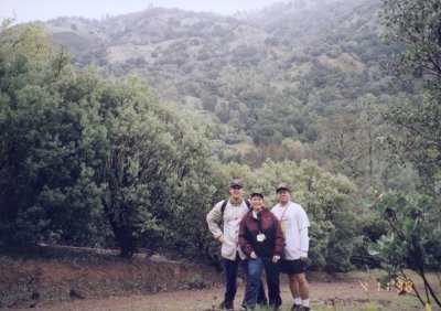
Hikers (8): Eric, Eugene, Frank, Jamie, Julia, Peter, Russ, Steve
Distance: 13 miles
Rating: 5 difficulty, 8 beauty
Park info: Henry Coe State Park east of Morgan Hill
Write-up by Peter
For my birthday, I decided to pick a memorable hike. You know it had to be Big Henry!
We arrived shortly after 10 o'clock on a cold and cloudy morning. The rumblings of discontent were already apparent among some of the not-so-intrepid hikers (Rusty). To make matters worse (or better, depending on your point of view), the rain picked up a notch just as we were loading up our backpacks. I love it!
Just as we were about to hit the trail, Julia and Frank showed up. A pleasant surprise! The good news was that they had showed up. The bad news was that they had no food or water. Oh well, they would make a tasty meal for the vultures.
1, 2, 3, ... INCH!
Right off the bat, I screwed up (actually the map was wrong) and we found ourselves on the wrong trail. We had ended up taking the Frog Lake Trail instead of the Monument and Northern Heights Trails, but it was no big deal since they both ended up at Frog Lake. Basically, we ended up walking around the Northern Heights instead of over them (virtually a flat trail, but at the expense of walking an extra mile).
Esteban and Egg jumped out in front and got separated from the pack pretty quickly. The rest of us kept up a fairly brisk pace but could not keep up with the frontrunners. Rusty was bringing up the rear. Eugene asked why Rusty was going so slowly, but I knew that The Man was just saving his energy for later. Wily veteran!
I could tell the people who hadn't been to Mt. Sizer before were thinking the whole day was going to be this easy. Just you wait, kids! After Frog Lake, things started to get tougher. We began our first uphill climb of the day. It was actually not very long, but there was some nice, slick mud to make the trail interesting.
The best part of the hike was about to begin. From the top of the ridge, it was a 1500-foot descent down into the gulch, followed by a steep climb (1500-foot rise in about 3/4 of a mile) up the other side to the top of Mt. Sizer, then back again. Let's get it on!
From the top of the ridge, we began the trip down into the gulch. Mt. Sizer
loomed over us on the other side. After walking downhill for more than half
an hour, we were still not at the bottom. The further we descended, the
taller Mt. Sizer looked. It started to dawn on the newbies that this was
not going to be so easy after all. On top of that, it had begun to sink in
that they were going to walk all this way back as well. I love Big Henry!
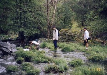
I slowed my pace in anticipation of the climb up the other side and pretty soon the pack was out of sight. I finally reached the stream at the bottom. Rusty, Frank, and Julia were waiting there, but everyone else had already begun the assault up Mt. Sizer. Time for a quick rest before the steep climb. The rain had stopped, so I took off my windbreaker and cap and stuffed them into my backpack. I needed to be as cool as possible during the climb.
The water in the stream was about ankle-high at the shallowest point. It
looked like it might be possible to cross over further down without getting
our feet wet, but I hate trying to balance on slippery rocks. More often
than not, I end up twisting an ankle or slipping off and getting my feet
wet anyway. I decided to just wade across. That water was COLD!
All right -- the preliminaries were over. Time for the main event. My best time for the uphill climb from the stream to the bench at the top had been 40 minutes in the past. My goal was to beat that time and to once again go all the way without stopping.
Ready, set, GO!
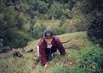
It doesn't take long for the initial burst of energy to dissipate. After 50 yards, you're breathing heavily. After 100 yards, you've slowed down noticeably. After 150 yards, your calves are burning. After 200 yards, you're down to a crawl. Mt. Sizer rocks!!
I could feel I was about to throw up the carrot sticks I had eaten about 20 minutes earlier. Maybe that was not such a smart thing to do! I could feel the chunks in the back of my throat as the juice flooded my mouth (don't you just love these graphic write-ups?). I just took a deep breath and kept going. I was not about to stop for anything.
With The Man up ahead for inspiration, I continued on. Gotta beat that 40-minute mark! Fortunately, the cool weather was a big help. At the second switchback, I spotted Eugene. He cursed me as I passed him by. I loved it!
Past the halfway mark, and I still felt good. I was even cracking jokes with Rusty! That 40-minute mark was going down! At the next turn, we passed a couple of back-packers (this is the only time we've ever seen anyone else walking up this trail). I felt like slowing down a tad, but I could see the trail flatten out slightly up ahead, so I forced myself to keep going.
Around the three-quarters mark, we met up with Jamie. Her complexion
was lovely tomato-like color. Big Henry will do that to you! No time
to chit-chat -- gotta keep moving -- we're almost there!!
I made it to the top in just over 37 minutes, a few seconds behind The Man, and 3 minutes better than my previous best. All right! 37 minutes on my 37th birthday! I now have a new goal in life: To come back and do this hike every year on my birthday and reach the top in the number of minutes that correspond to my age. Let's see how long that will last. Probably not too long -- Big Henry always wins in the end.
We sat on the bench, huffing and puffing for a few minutes. Esteban
and Eric had obviously gone up further along the ridge to the true peak
of Mt. Sizer (it's about a mile away, but only 200 feet higher in
elevation). Once you make it to the bench, that extra mile is just
a cake-walk, but we knew the boys would give us grief if we didn't
do it. Just as we were about to set out, Jamie showed up, followed
shortly thereafter by Julia, Frank, and Eugene. We took a couple of
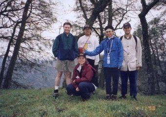
pictures at the top (did I mention there's a great view from up there?)
and then headed out. Eugene decided to rest on the bench and then
head back down.
As we arrived near the peak, we saw the others walking back towards us. Esteban was flailing his arms about for some reason, and Egg was wearing his garbage-bag like plastic poncho. What a lovely couple! We were starving, so we didn't spend much time socializing and just exchanged grunts and kept on walking.
Finally, lunchtime! We sat on a damp log near the radio transmitter. Every muscle in my body was sore. We were only at the halfway point! Oh, man! Well, no time to worry about that now -- gotta eat! Julia and Frank had not brought lunch, so The Man graciously gave up half his sandwich to Frank. I offered half of mine to Julia, but she declined. I don't know if she really didn't want it, or if she was scared that I might kill her if she accepted the offer. In either case, I was too tired and hungry to think about it.
I think I ate my sandwich in record time. It's amazing how fast you can eat when you don't waste time chewing the food. I just washed those big chunks of turkey and sourdough bread down with iced tea and kept going. Gourmet dining, it was not.
It was pretty cold up at the top and we had a long trek ahead of us, so we didn't rest too long and loaded up and hit the trail. Another INCH cheer for inspiration:
1, 2, 3, ... INCH!
After passing the famous bench, we began the steep descent. Right at that point, the sun finally broke out from behind the clouds. The warmth felt good, and valley below looked beautiful. This is what makes all the pain and suffering worthwhile.
By the time we made it to the bottom, I was actually hot, so I looked forward to walking through the stream. I chose the deepest point and went in up to my shorts. The cold water felt great on my aching legs.
On the other side, I found a nice flat rock and rested for a bit while taking off my boots and wringing out the socks. It was already past 3 o'clock and there was still two hours worth of hiking to do, so there was not much time to relax. I laced up and headed out.
The climb up from the gulch was much less steep than the climb up Mt. Sizer, but it seemed to stretch on forever. As I rounded a switchback, I came upon a signpost indicating Deer Horn was 1.2 miles away. I had thought it was about a quarter-mile away. That was demoralizing! I re-evaluated my rate of water consumption. Had to make those bottles last longer.
I finally arrived back at Frog Lake. I was tempted to think I was home free at this point, but then I remembered the incident with the wild pigs in this park last summer, so I took nothing for granted.
Less than a mile to go, and I caught my second wind (well, maybe not second, more like sixteenth). I even went off trail and did a little half-mile detour to visit the Henry Coe Monument. I figured after having been here and hiked so many trails, I owed it to go and pay my respects to Big Henry.
I rested there for a few minutes and enjoyed the tranquility of the place. The sound of the breeze blowing through the trees was so peaceful. I just wanted to lie down in the grass, but was afraid that if I did so, I might fall asleep.
Time to get this thing over with. As I came over the final ridge and saw the parking lot down below, I broke out in a big smile. This trail ends much better than the Pacheco Trail that we have always taken in the past (you end up going downhill instead of finishing on an uphill). A great end to a great hike.
Thank you, Big Henry!
![]()
![]()
Pages maintained by Steve Walstra,
Peter Saviz, and
Russell Gee.
©2026 Intrepid Northern California Hikers