
| Main Page | Diary | Leaves | Stats |

82. Coit Lake (08/15/98)
Hikers (6): Jane M, Mary, Peter, Pistol Pete, Russ, Steve
Distance: 14 miles
Rating: 3 difficulty, 8 beauty
Park info: Henry Coe State Park east of Morgan Hill
Write-up by Peter
This was originally supposed to be a nice 14-mile hike at Henry Coe State Park, featuring Coit Lake. Straightforward, right? Wrong! The long and short of it is that six INCHers went hiking at Henry Coe (one group of 2 on Saturday, one solo hiker later on Saturday, and a group of 3 on Sunday), and only the solo hiker made it to the lake! Good job by Mary!
For the ugly details, read on .......
It all started innocently enough on Friday afternoon, when Egg suggested that we go out and sample some Spaten Oktoberfest beer after work. Well, the "samples" they provided were a liter each! After a few samples, we were feeling pretty happy (or were we just numb?).
Well, the next morning comes around, and my sense of happiness had been replaced by a splitting headache and stomach nausea. Let that be a lesson to you boys and girls out there! At least I was not alone -- Rusty was also feeling pretty green. We called up Esteban and told him we would not be able to make it. Black Leaves Of Shame for both of us!
Esteban was a trooper, and he and Pistol Pete forged ahead to Henry Coe. They claim they stopped at my place to pick up the map and rang the doorbell for hours to try and get my "drunken ass out of bed", but I deny all knowledge of this! There is also an unconfirmed rumor of a Nanda sighting, but apparently it was short-lived.
1, 2, 3, ... INCH!
Esteban and Pistol did not fill me in on the gory details (except Pistol telling me Henry Coe kicked his butt). All I know is that they showed up at Park Headquarters, saw it was a 26-mile round-trip hike to Coit Lake (that's why we were supposed to start from the other entrance!) and did another 10-mile loop instead. From what I gather, they headed out on the Soda Springs trail to Manzanita Point, then down to China Hole, through the dry river bed and over to Poverty Flat, then up the Middle Ridge and back in to Park HQ on the Fish Trail. Not a bad day's work!
Meanwhile, back at the ranch ... Mary showed up late at Intel, and went down to Henry Coe by herself. Unlike the other two goofballs, she went to the right entrance. I wasn't there, but I'm assuming Mary did the INCH cheer before heading out.
1, 2, 3, ... INCH!
The trail led her up the Jackson Trail (elevation gain of 1500 feet in under 2 miles), then along the top of the ridge to Kelly Lake, then around Willson Field Hill to Coit Lake, where she stopped to enjoy lunch while admiring the view. Lunch always tastes better if you have to work for it!
On the way back, she took the Cross-Canyon Trail (poison oak, anyone?) and then dragged herself back on the endless Coit Route, savoring those last drops of water as she finally made it back to the car at 8 pm. Whew!! Say it Mary: Henry Coe kicked my butt! Big Henry does a lot of that.
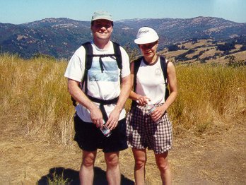
Rusty and I finally got our act together by Sunday. We hooked up with Jane, and headed down to Henry Coe's Gilroy Hot Springs entrance.
One more time ...........
1, 2, 3, ... INCH!
We started out on the same trail as Mary. As the trail was about to branch off, we saw a couple of rangers and confirmed with them that we were heading in the right direction. One of the them told us that they had recently done some trail work and the trail was not as "radically steep" as before. Not good -- we like steep!
We headed up the Anza Trail (which was not on any of our maps). Right there, we should have known that this was a bad sign. After working our way up a series of switchbacks, we emerged in a grassy field. Looking back, we could see a nice view of the tree-covered ridge on the other side. Very nice!
Jane and I continued on up. Rusty stayed behind, ostensibly to "water the plants", but no sooner were Jane and I around the corner than we heard some loud mooing of cows behind us. The Man strikes again!!!!
We finally reached Jackson Field and paused briefly to rest and take a
couple of photos (Rusty has been carrying the same roll of film in his
camera for months now and no matter how many pictures he takes, it never
seems to end).
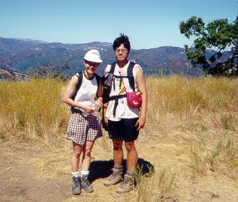
After the break, we walked along the top of the ridge towards Kelly Lake. I estimated it was about a mile away. We walked ... and walked ... and walked ... and walked. Over an hour went by and still no sign of Kelly Lake. Hmmmmmm. Had it dried up? We kept walking.
After about another half hour, we saw a small lake off to the left. The problem was that Kelly Lake was supposed to be on our right. Hmmmmmmmm.
We kept going ....
The trail started leading downhill and bottomed out in a flat area with a muddy pond. This was definitely nowhere on the map. Looking around, it seemed that this area used to be fenced off, but now the trail was leading right through it. I figured we had to be somewhere off the map, walking though some private land. It would only be a matter of time before some cranky farmer came after us with a shotgun!
We kept going, and after a while, we hit a T-junction. The left branch looked like it was leading back towards the area we wanted to be in, so we took it. The trail went sharply downhill to a dry creek bed, then across and back up the other side.
As we trudged up the steep hill, we could hear some large animals trashing about in the bushes off to the side. Sure enough, a couple of moments later, a pack of wild pigs came running across the trail. If I wasn't so tired, I might have been startled.
We were starting to get more than a little hungry. We had been walking for three and half hours now and it seemed that we were still on the road to nowhere. Jane had mentioned that she needed to get home by 4 o'clock. It was already 1:30. Even if we headed back the way we came, we wouldn't get to the car until 5 o'clock. If we kept going forward, there was no guarantee what would happen. Hmmmmmmmm.
As Napoleon (or someone else) once said, it is best to retreat in the face of a certain loss and live to fight another day. I decided to call an end to the misery. There were no objections from Jane or Rusty. We sat under a shady tree and ate our lunch in silence, enjoying the cool breeze and a well-deserved rest.
We wanted to sit there for a few more hours, but we had to head back. Reluctantly, we hit the road once again. Back down the hill to the dry creek bed and up the steep incline on the other side. As we made our way up the hill, we came across a lone hiker (the first person we had seen in over 3 hours).
It turned out he had started out from the Hunting Hollow entrance heading to Coit Lake and was also lost. Good to know we're not alone! In looking at his map, we discovered that his map of this section of the park was quite different from ours. Who knew that park trails would change? This brings up yet another Hike Lesson: Always carry an up-to-date map!
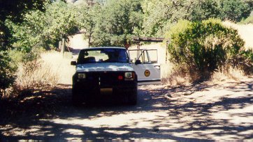
At least we had a semi-excuse for being lost, but it still didn't solve the problem. We still had no idea where we were. We walked back together with our new friend. As we arrived back at the muddy pond, we heard the sound of a car approaching from behind. It was a Park Ranger!
Jane flagged him down and we asked him to show us where we were. He explained to us that this part of the park had been recently purchased and opened up to the public, which explained why none of the trails had been marked. He started to give us grief about being helpless hikers stuck in the wilderness, biting off more than we could chew, etc., etc., but after we explained that we had been to Henry Coe many times and that we did not have a map of the new section of the park, he seemed to calm down a little.
Seeing as Jane was running late, she asked the ranger to give us a ride back to the car. Given the ranger's earlier grumpiness, I was surprised he agreed to do it. Normally, this would be Black Leaf territory, but seeing as Jane was running late, Rusty and I gave in (hey, one Black Leaf per hike is enough!).
The ride back was quite interesting. We had to take the fire roads all the way, and so ended up taking a long route and got to see quite a large area of the park. This place is huge! The downside was that the ranger was driving like a maniac and I for one did not think we'd make it back to the car in one piece. I have to say those Jeep Cherokees are a lot more durable than I had imagined!
He dropped us off about a quarter-mile from the car. It was good to
be back on solid ground again! We thanked him and headed off. Rusty
even took a picture of him (gotta keep burnin' that film!).
I have to say that on the way back, Jane's driving put the Maniac Ranger's to shame. Remind me not to ask her to drive on days when she has to get back in a hurry! Between the Oktoberfest, wild pigs, Maniac Ranger, and Jane, I'm considering it a miracle that we made it out of this weekend alive.
![]()
![]()
Pages maintained by Steve Walstra,
Peter Saviz, and
Russell Gee.
©2026 Intrepid Northern California Hikers