| Salt Creek
(Cook, DuPage Counties, Illinois, U.S.A.) |
| We are not responsible for errors or omissions. When boating, regardless of water depth, wear a PFD! |
| Salt Creek
(Cook, DuPage Counties, Illinois, U.S.A.) |
| We are not responsible for errors or omissions. When boating, regardless of water depth, wear a PFD! |
![[lagrange.gif]](lagrange.gif)
Going through the rocks just before the LaGrange Road bridge on Salt Creek.
We canoed Salt Creek from Bemis Woods North (easy access to creek) to Westchester Woods on 7/27/96 (Westchester Woods is right across the creek from Brezina Woods, but a shorter distance to the cars from the creek). The creek is pretty shallow right now and in several places, I couldn't get my entire paddle in the water. We had two kayaks and one aluminum canoe with us on the trip.
Hazards: Between Bemis Woods and 31st Street there is a log jam blocking the entire creek and there is a fallen tree that spans the entire creek (maybe it's one foot off the waterline, I thought I had ducked low enough until I felt the whomp of impact on my head). Also there is a small dam at Possum Hollow Woods (it's not shown on the Forest Preserve Maps). When portaging around the log jam we discovered (actually the bow person in the aluminum canoe did) that the mud along the shores is soft, smelly and about knee deep. Be careful when you portage. Also, there is a mattress (twin size) caught up in the trees, and several bicycles to avoid in the creek.
Our trip should have taken about 2 hours, however between the portages, and shallow water, the trip took us 4+ hours (most of the portage time was consumed by finding a spot that we could get out without sinking into the muck). The creek has enough short, rocky rapids to make the creek interesting (the aluminum canoe kept getting grounded in them, while the kayaks scraped bottom but floated through without having to get out and push).
Note of caution: Be careful as you emerge from the trees with your canoes. I came barging out of the woods helping drag the aluminum monster and startled an elderly woman and her dog. The dog (on a leash) ran around her owner several times winding the leash around her feet, Then the woman attempted to step back off the curb and fell over into the parking lot. She was unharmed. I guess she just wasn't expecting a big oaf in a white pith helmet charging out of the woods dragging a canoe.
Overall: It was a fun trip, even if we did get rained on, extremely muddy (I'VE NEVER HAD MUD ON MY SHOULDERS FROM A CANOE TRIP BEFORE WHEN I DIDN'T TIP...) and stuck a lot. There are many wildlife tracks visible in the banks along the creek. We also saw many birds, and a beaver (who didn't seem to mind us until we started to pass him/her).
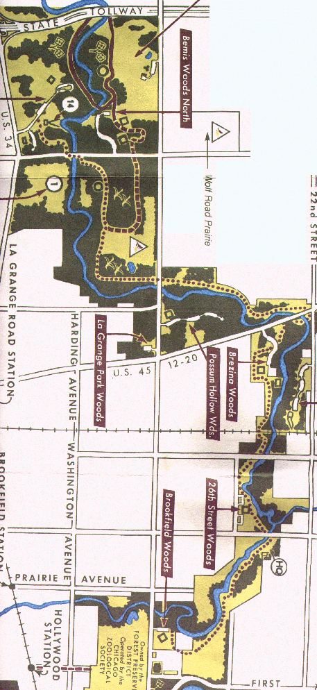
Because it takes me some time to complete a map, here's a Forest preserve map of the area that can be used in the mean time. If you see an old rusting (but still used) railroad bridge, it means you've gone past Brezina Woods (I marked the end of the trail before starting so we'd know...., you should too as it all looks pretty much the same through most of the trip).