| Dams and obstructions in the Chicago area
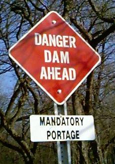
Never paddle over a low head dam.
. |
| We are not responsible for errors or omissions. When boating, regardless of water depth, wear a PFD! |
| This information is provided free and is worth
every cent! Always scout first, don't blindly go over a dam with a boat ramp.
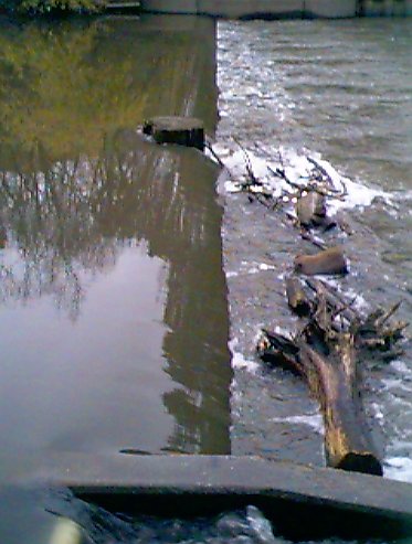
Strong currents can move large objects and going blindly down a boat ramp into a
uprooted tree can ruin your entire day!
If you encounter a new dam or obstruction let us know. There are a couple of new cable dams (creating wetlands) we know exist on the upper Des Plaines, that need exploring. Photos and GPS coordinates would be appreciated! |
|
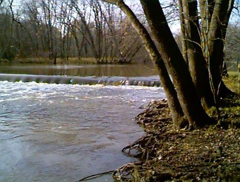
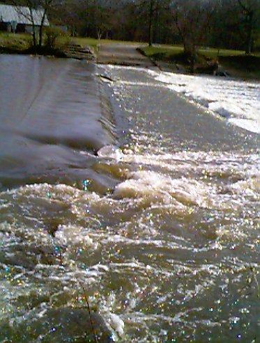
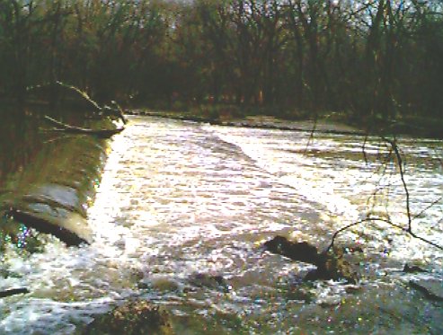
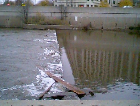
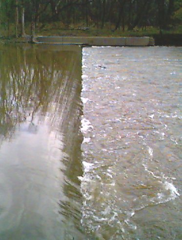
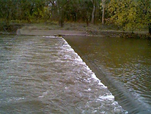
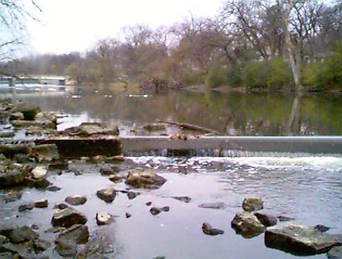
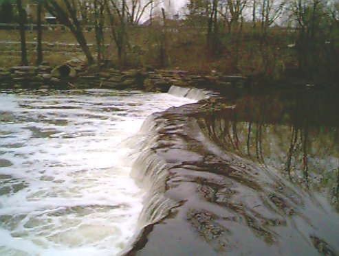
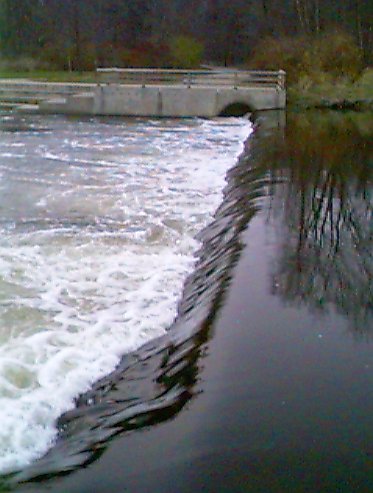
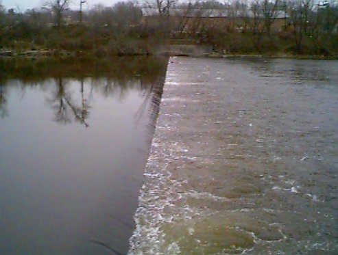
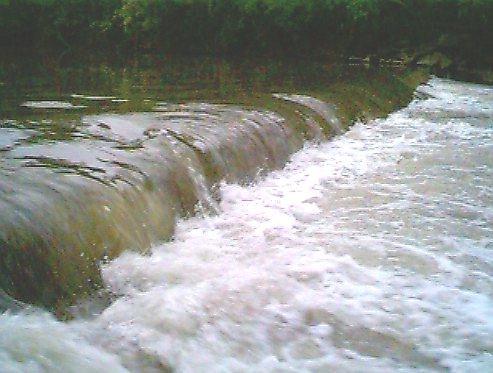
Many (but not all) dams have warning signs before the dam. However, most warning signs are so close that you can't read them until it's too late. Watch for the horizon line.
Don't paddle over a low head dam.
. |
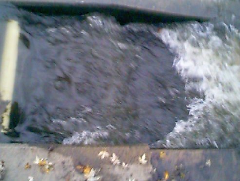
![[Drowning Machine]](dam.gif)
|
|
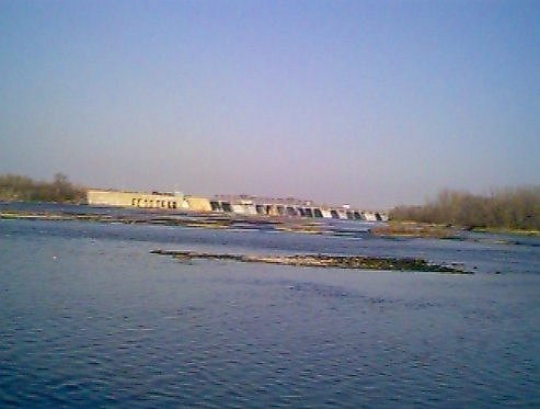
Dams are listed by river and river mile from the junction of the Illinois
River with the Mississippi River. There is
a photo of each dam as well as the longitude and latitude. New for 2006, the latitude
and longitude coordinates now link to a Google map. There are still links to the U.S. Census Bureau's
Tiger Mapping Service, Mapquest, and Topozone for each dam. The Topozone maps will take you to a USGS topographic map, with our little boat man The coordinates and pictures have been gathered by visiting each dam. All the coordinates will be just slightly off due to where the reading was taken (very few were done at the middle of a dam or lock), or the Selective Availability (SA) feature of GPS being turned on. (Please let us know if a particular link seems way off.) Note: We've made a reasonable (perhaps bordering on the insane) attempt to locate dams in the Chicagoland area, but we may have missed some. If we passed an area during times of high water, dams sometimes washout and are not visible (there is one Des Plaines dam that I first thought was a nice wave, a later trip revealed it to be a dam). Be Alert. |
 pointing his paddle to the feature in question.
Calumet River |
||||
| Distances in the table below are from the mouth of the Illinois River. The Cal-Sag Channel meets the Des Plaines River 303.5 miles from the mouth of the Illinois River at the Mississippi. | ||||
| Name,City | Picture | River Mile |
Dam Height (in feet) |
GPS Position |
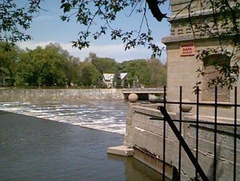
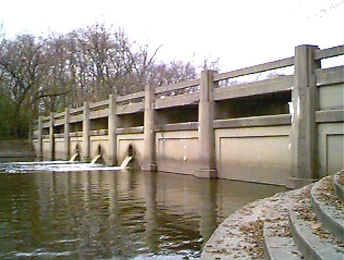
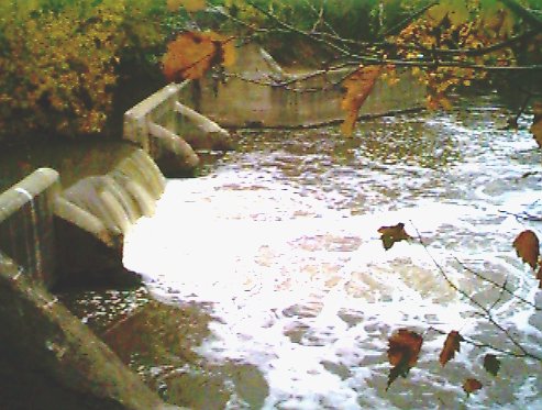
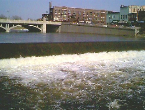
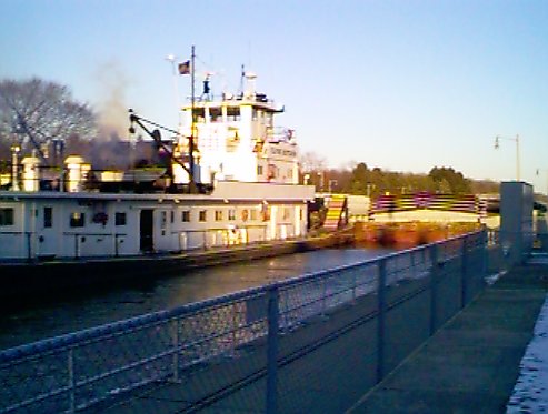
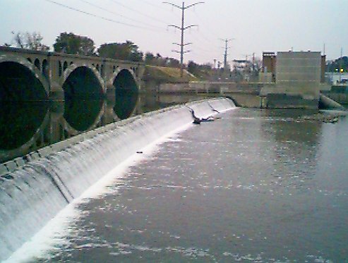
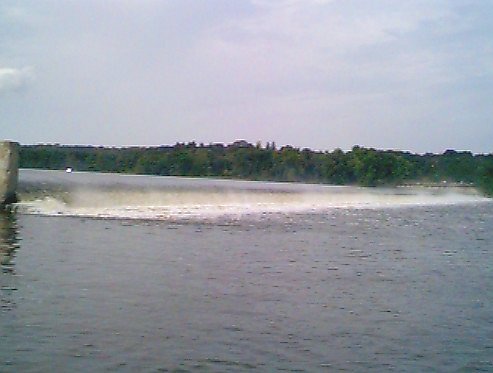
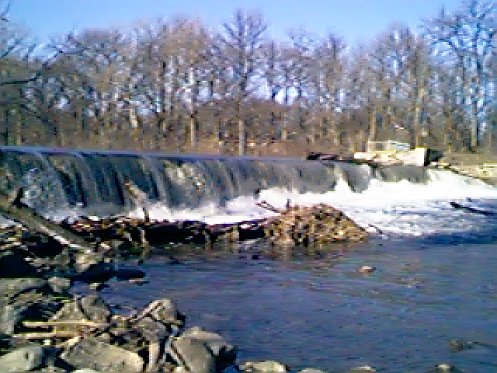
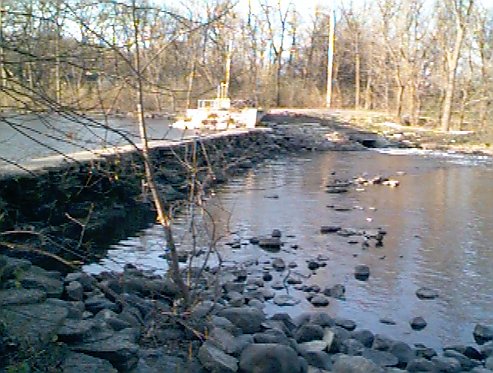
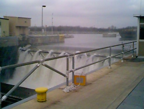
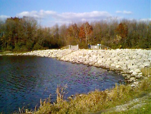
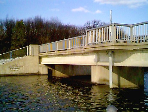
| T. J. O'Brien Lock & Dam, Chicago
135th Street and Stony Island Ave. The Army will run the lock for kayaks and canoes however it may be quicker to portage on river left (east bank) to avoid the lock works. Commercial Navigation has top priority for using the lock. |
 |
326.5 | 5.7 |
41 39.134N 87 34.075W [Tiger] [Mapquest] [Topozone] |
![[Topozone]](http://www.topozone.com/map.asp?lat=41.6522&lon=-87.5665&s=25&u=1&sym=http://pages.ripco.net/%7ejwn/info.gif&symx=13)
Chicago River | ||||
| Distances in the table below are from the mouth of the Illinois River. The Chicago River meets the Ship and Sanitary Canal 321 miles from the mouth of the Illinois River at the Mississippi. | ||||
| Name, City | Picture | River Mile |
Dam Height (in feet) |
GPS Position |
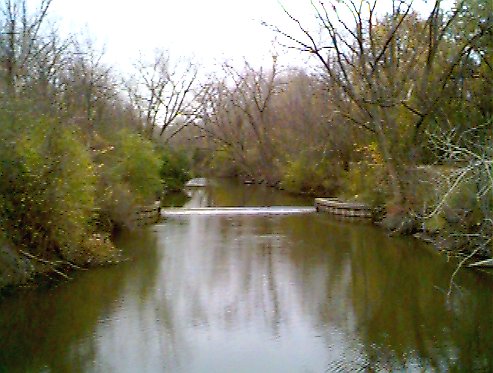
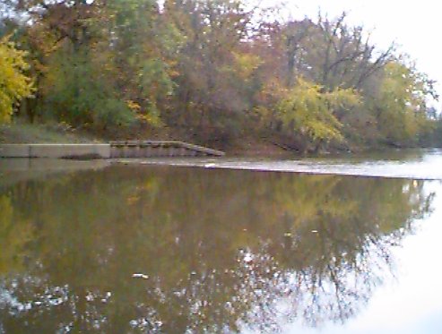
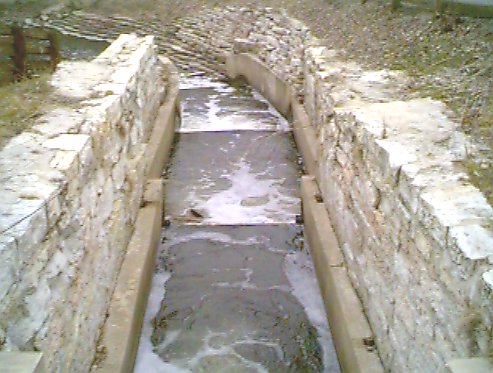
| Willow Road Dam, Skokie Lagoons
East Fork, North Branch. Portage on east side at the stairs. See Skokie Lagoons for more dam information |
 |
10.0 |
42 06.119N 87 45.545W [Tiger] [Mapquest] [Topozone] |
|
| Winnetka Dam, Winnetka
East Fork, North Branch, Chicago River (a.k.a. Skokie River) 100 yards north of Winnetka Road bridge. No ramps, steep banks, portage river left (east) to dirt trail and avoid the thicket on other side. |
 |
351.5 | 2.0 |
42 05.668N 87 45.430W [Tiger] [Mapquest] [Topozone] |
| Chick Evans Golf Course Dam, Morton Grove
Just north of Beckwith Road.Muddy portage on river left |
 |
342.7 | 2.0 |
42 03.040N 87 46.854W [Tiger] [Mapquest] [Topozone] |
| Tam O'Shanter Country Club Dam, Niles
Just south of Howard Street |
 |
341.8 | 1.0 |
42 01.040N 87 47.702W [Tiger] [Mapquest] [Topozone] |
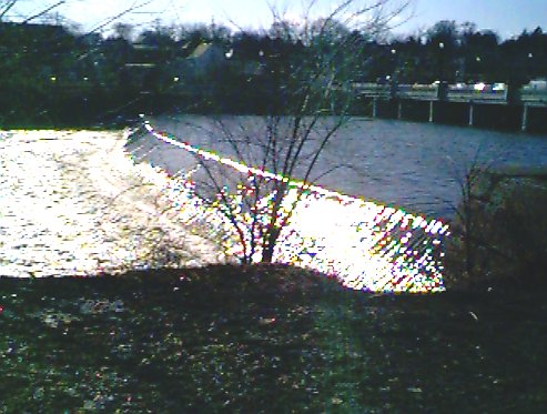
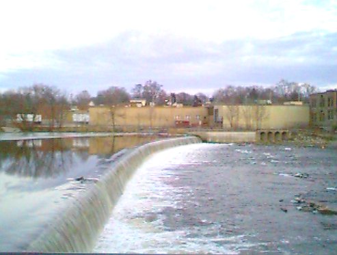
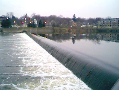
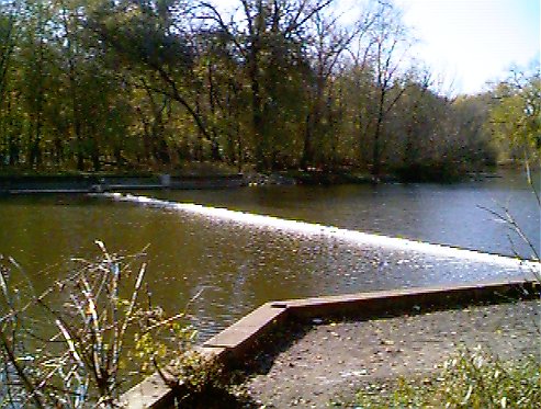
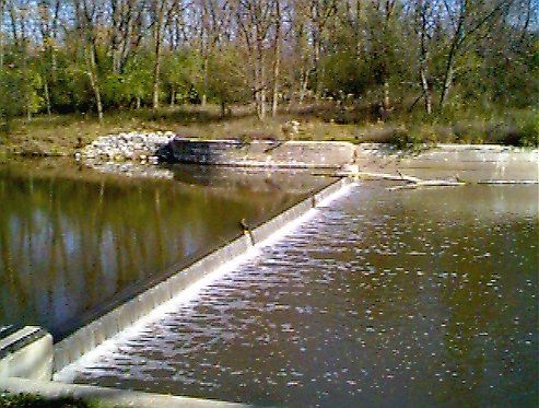
| North Branch Spillway, Chicago
50 yards east of junction of Albany Street and River Either end your trip in LaBagh Woods or plan on no easy portage. At footbridge just before spillway, there is a hole in the fence on river left. You can exit the river there, or get out of your boat, lead your vessel downstream via your painter line (you must not be in your boat at this point, you must be on shore!) to the dam, scale the concrete wall yourself and let your vessel go over the dam and then pull it back via your painter line. Scout before you take your trip! |
 |
333.6 | 4.0 |
41 58.436N 87 42.296W [Tiger] [Mapquest] [Topozone] |
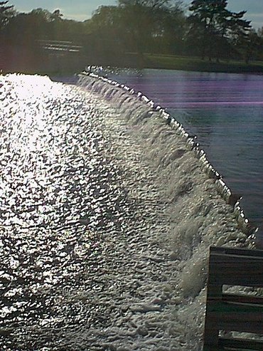
| Centennial Fountain, Chicago
East of Lake Shore Drive on main channel. It's not a dam, but can stop you dead in your tracks. For 10 minutes every hour, the MWRD sprays a fountain of river water across the river during the summer months. Tastes great and less filling. |
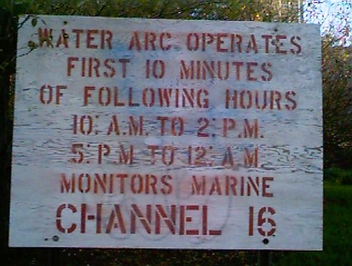 |
327.0 | 0.0 |
41 53.297N 87 36.815W [Tiger] [Mapquest] [Topozone] |
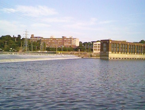
| Chicago Harbor Lock, Chicago
Junction of Chicago River and Lake Michigan. If you have a IDNR Sticker on your boat, the Army will allow you to use the lock. Note: while 5.7 may be the posted difference based on lake level of 577 feet, lake levels vary greatly and the present difference (586 feet) is about 1 foot. |
 |
327.2 | 5.7 |
41 53.255N 87 36.688W [Tiger] [Mapquest] [Topozone] |
![[Topozone]](http://www.topozone.com/map.asp?lat=42.1012492&lon=-87.7592926&s=25&u=1&sym=http://pages.ripco.net/%7ejwn/info.gif&symx=13)
![[Topozone]](http://www.topozone.com/map.asp?lat=42.09448&lon=-87.75717&s=25&u=1&sym=http://pages.ripco.net/%7ejwn/info.gif&symx=13)
![[Topozone]](http://www.topozone.com/map.asp?lat=42.0508957&lon=-87.7804337&s=25&u=1&sym=http://pages.ripco.net/%7ejwn/info.gif&symx=13)
![[Topozone]](http://www.topozone.com/map.asp?lat=42.0175133&lon=-87.7957687&s=25&u=1&sym=http://pages.ripco.net/%7ejwn/info.gif&symx=13)
![[Topozone]](http://www.topozone.com/map.asp?lat=41.9738388&lon=-87.7049332&s=25&u=1&sym=http://pages.ripco.net/%7ejwn/info.gif&symx=13)
![[Topozone]](http://www.topozone.com/map.asp?lat=41.8883&lon=-87.6136&s=25&u=1&sym=http://pages.ripco.net/%7ejwn/info.gif&symx=13)
![[Topozone]](http://www.topozone.com/map.asp?lat=41.8883&lon=-87.6115&s=25&u=1&sym=http://pages.ripco.net/%7ejwn/info.gif&symx=13)
Des Plaines River | ||||
| Our data is missing the two new cable dams for the wetlands project that have been added far north in Lake County. In both cases, for the cable dams, portage river right.
Distances in the table below are from the mouth of the Illinois River. The Des Plaines River meets the Illinois River 273.0 miles from the mouth of the Illinois River at the Mississippi. |
||||
| Name, City | Picture | River Mile |
Dam Height (in feet) |
GPS Position |
| Cable Dams
These two dams are part of a wetlands restoration project in Lake County. They are not solid and designed to simulate beaver dams. Do not run these! |
N/A | 1.0 | ||
| Wagon Trail Dams
Twin low dams located south of Rt. 120 and Buckley just before the rail bridges. These dams were created as part of the Illinois - Minnesota wagon trail system in the 1800's to avoid the swamps between the headwaters of the Des Plaines and Root Rivers |
N/A | 1.0 | ||
| Hollister Dam, Lake Co.
Located just north of the southernmost building in the Hollister complex. There is a groove near the center created by the Lake County Forest Preserve as a boat chute that can be used depending on water height, Scout first. If not, and there is only a small group of you I'd suggest portaging on the Hollister side (river right) rather than the heavily overgrown forest preserve section on river left |
 |
368.8 | 1.0 |
42 14.927N 87 56.553W [Tiger] [Mapquest] [Topozone] |
| Wagon Trail Dams
Twin low dams located south of Rt 120 and Buckley just before the rail bridges. These dams were created as part of the Illinois - Minnesota wagon trail system in the 1800's to avoid the swamps between the headwaters of the Des Plaines and Root Rivers |
N/A | 1.0 | ||
| Wright Forest Preserve Dam | N/A | 2.0 | ||
| Ryerson Dam, Deerfield Watch for red warning sign just upstream and cabin on river left. Portage river left |
 |
350.6 | 2.0 |
42 10.516N 87 55.018W [Tiger] [Mapquest] [Topozone] |
| Dam #1, Wheeling Dam #1 and #2 are identical and have white or orange warning signs upstream. Portage river left |
 |
346.5 | 4.0 |
42 07.412N 87 53.728W [Tiger] [Mapquest] [Topozone] |
| Dam #2, Mount Prospect Dam #1 and #2 are identical and have white or orange warning signs upstream. Portage river left |
 |
342.0 | 4.0 |
42 04.913N 87 53.443W [Tiger] [Mapquest] [Topozone] |
| Dempster Street Dam, Park Ridge 50 feet south of Dempster Street bridge. This dam has a boat chute on river left that is about 36 inches wide. Scout first or portage river left. |
 |
336.5 | 2.0 |
42 02.312N 87 51.954W [Tiger] [Mapquest] [Topozone] |
| Touhy Dam, Park Ridge
200 yards north of Touhy Street bridge. This dam has a boat chute on river left that is about 36 inches wide. Scout first or portage river left. |
 |
334.2 | 2.0 |
42 00.793N 87 51.914W [Tiger] [Mapquest] [Topozone] |
| Dam #4, Park Ridge This dam has a boat chute on river right. Scout first or portage river right. They are hard to notice due to the low profile |
 |
332.5 | 2.0 |
41 59.652N 87 51.584W [Tiger] [Mapquest] [Topozone] |
| North Avenue Dam, River Forest
200 yards north of North Avenue bridge This dam is identical to Dam #4 and has boat chute on river right. Scout first or portage river right. |
 |
324.5 | 2.0 |
41 54.83N* 87 49.83W* [Tiger] [Mapquest] [Topozone] |
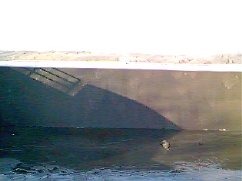
| Hoffman Dam, Lyons
100 feet west of Joliet Ave, at Hofmann Tower, watch for tower and horizon line as the warning sign is too close to be of any use. In the past, if you attempted to portage river left, the Riverside (name of the town) Police would ticket you. Power boaters will want to turn back before encountering the dam. Canoes/Kayaks can make a long portage from Plank Woods Meadow on RIVER RIGHT to forest preserve area just past Hoffman Dam on Joliet Street. Watch out for weir just downstream. |
 |
316.5 | 12.0 |
41 49.220N 87 49.341W [Tiger] [Mapquest] [Topozone] |
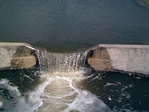
| Weir Dam, Lyons
150+ feet east of Joliet Ave, within view of Hofmann Tower Portage river right |
 |
316.0 | 2.0 |
41 49.362N 87 49.206W [Tiger] [Mapquest] [Topozone] |
| Beartrap Dam, Romeoville (inbound from the S&S Canal)
140th Street and Des Plaines River This drops into Des Plaines (which you're already on), no portage needed |
N/A | 293.15 | 8.0 |
41 35.856N 88 03.938W [Tiger] [Mapquest] [Topozone] |
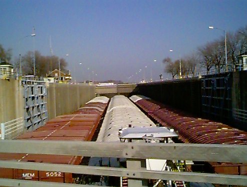
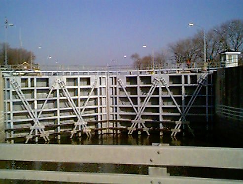
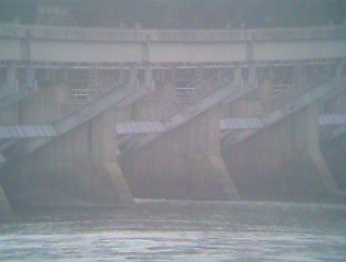
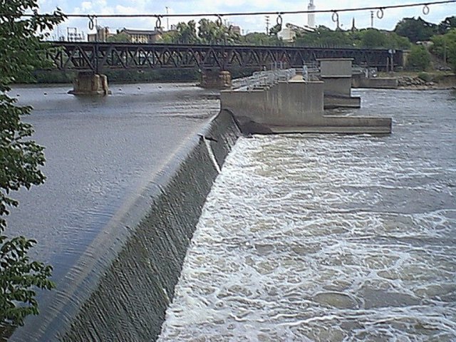
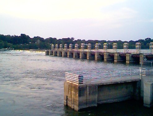
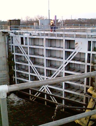
| Brandon Lock & Dam, Rockdale
Just north of Brandon Road. View of the lock open, view of the lock closed. I know of no way around this lock without waiting your turn to Lock thru it |
 |
286.0 | 34.0 |
41 30.210N 88 06.250W [Tiger] [Mapquest] [Topozone] |
![[Topozone]](http://www.topozone.com/map.asp?lat=42.2486&lon=-87.9425&s=25&u=1&sym=http://pages.ripco.net/%7ejwn/info.gif&symx=13)
![[Topozone]](http://www.topozone.com/map.asp?lat=42.1751&lon=-87.9179&s=25&u=1&sym=http://pages.ripco.net/%7ejwn/info.gif&symx=13)
![[Topozone]](http://www.topozone.com/map.asp?lat=42.1235&lon=-87.8954&s=25&u=1&sym=http://pages.ripco.net/%7ejwn/info.gif&symx=13)
![[Topozone]](http://www.topozone.com/map.asp?lat=42.0818&lon=-87.8900&s=25&u=1&sym=http://pages.ripco.net/%7ejwn/info.gif&symx=13)
![[Topozone]](http://www.topozone.com/map.asp?lat=42.0384&lon=-87.8824&s=25&u=1&sym=http://pages.ripco.net/%7ejwn/info.gif&symx=13)
![[Topozone]](http://www.topozone.com/map.asp?lat=42.0132&lon=-87.8652&s=25&u=1&sym=http://pages.ripco.net/%7ejwn/info.gif&symx=13)
![[Topozone]](http://www.topozone.com/map.asp?lat=41.9938&lon=-87.8591&s=25&u=1&sym=http://pages.ripco.net/%7ejwn/info.gif&symx=13)
![[Topozone]](http://www.topozone.com/map.asp?lat=41.9120&lon=-87.8336&s=25&u=1&sym=http://pages.ripco.net/%7ejwn/info.gif&symx=13)
![[Topozone]](http://www.topozone.com/map.asp?lat=41.8207&lon=-87.8226&s=25&u=1&sym=http://pages.ripco.net/%7ejwn/info.gif&symx=13)
![[Topozone]](http://www.topozone.com/map.asp?lat=41.8227&lon=-87.8201&s=25&u=1&sym=http://pages.ripco.net/%7ejwn/info.gif&symx=13)
![[Topozone]](http://www.topozone.com/map.asp?lat=41.5975&lon=-88.0656&s=25&u=1&sym=http://pages.ripco.net/%7ejwn/info.gif&symx=13)
![[Topozone]](http://www.topozone.com/map.asp?lat=41.5036&lon=-88.0987&s=25&u=1&sym=http://pages.ripco.net/%7ejwn/info.gif&symx=13)
DuPage River | ||||
| Distances in the table below are from the mouth of the Illinois River. The DuPage River meets the Des Plaines River 277.2 miles from the mouth of the Illinois River at the Mississippi. | ||||
| Use caution in times of high water due to very low clearance under most bridges. | ||||
| Name, City | Picture | River Mile | Dam Height (in feet) |
GPS Position |
| Warrenville Dam, Warrenville
Located north of Warrenville Road bridge. Beware of the Mill/Fish chute river right before second dam warning buoy. The Chute is not quite wide enough for boats and has too much curve at the end (Front and Back ) You'll want to portage river right at the grass opening just before the chute |
 |
344.1 | 4.0 |
41 49.309N 88 10.377W [Tiger] [Mapquest] [Topozone] |
| McDowell Dam, Naperville
Located just south of McDowell Preserve entrance bridge. This is a low bridge and may require portage during high water Portage river left at one of the two openings in the tall grass before the dam. The first opening has sand, but is longer carry, the second is shorter but is a mud bank. |
 |
311.5 | 2.0 |
41 49.289N 88 10.345W [Tiger] [Mapquest] [Topozone] |
| Fawell Dam, Naperville
Large earthen floodgate with a small green building on top (outhouse sized) |
310.5 |
41 47.175N 88 10.824W [Tiger] [Mapquest] [Topozone] |
||
| Hammel Woods, Shorewood
100 feet north of U.S. 52 Bridge Portage river right |
 |
287.2 | 3.0 |
41 31.361N 88 11.585W [Tiger] [Mapquest] [Topozone] |
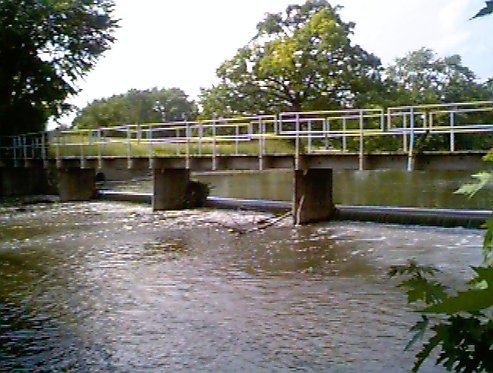
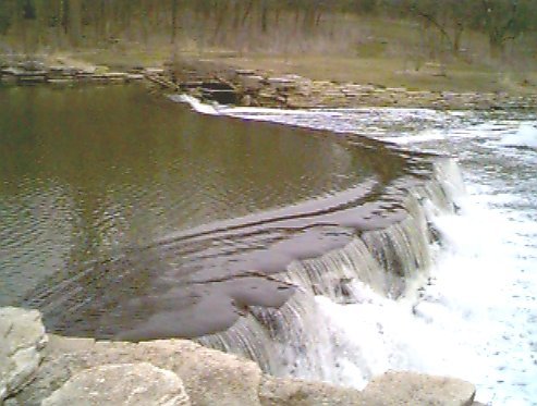
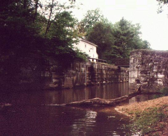
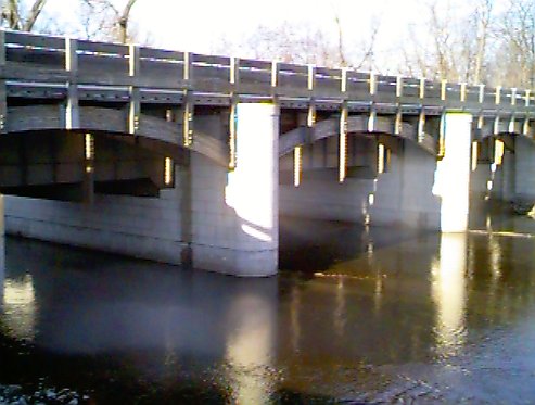
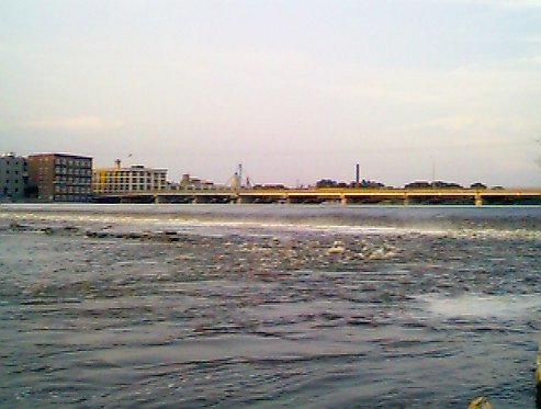
| Channahon Dam, Channahon
300 yards south of Illinois Route 6 Bridge. Built by the WPA to replace the aging Bridge Street Dam constructed in 1847 for the I&M Canal. Portage river left at stairs in front of of lock#6 |
 |
278.7 | 10.0 |
41 25.357N 88 13.713W [Tiger] [Mapquest] [Topozone] |
![[Topozone]](http://www.topozone.com/map.asp?lat=41.8215&lon=-88.1724&s=25&u=1&sym=http://pages.ripco.net/%7ejwn/info.gif&symx=13)
![[Topozone]](http://www.topozone.com/map.asp?lat=41.7956&lon=-88.1870&s=25&u=1&sym=http://pages.ripco.net/%7ejwn/info.gif&symx=13)
![[Topozone]](http://www.topozone.com/map.asp?lat=41.7863&lon=-88.1804&s=25&u=1&sym=http://pages.ripco.net/%7ejwn/info.gif&symx=13)
![[Topozone]](http://www.topozone.com/map.asp?lat=41.5222&lon=-88.1934&s=25&u=1&sym=http://pages.ripco.net/%7ejwn/info.gif&symx=13)
![[Topozone]](http://www.topozone.com/map.asp?lat=41.4221&lon=-88.2281&s=25&u=1&sym=http://pages.ripco.net/%7ejwn/info.gif&symx=13)
Fox River | ||||
| Distances in the table below are from the mouth of the Illinois River. The Fox River meets the Illinois River 239.4 miles from the mouth of the Illinois River at the Mississippi. | ||||
| Nearest City | Picture | River Mile | Dam Height (in feet) |
GPS Position |
| McHenry Lock & Dam
No need to portage. Lock operates for all powered, sail driven or paddle propelled canoes, kayak... even float tubes at no charge |
 |
337.1 | 7.0 |
42 18.33N 88 15.01W [Tiger] [Mapquest] [Topozone] |
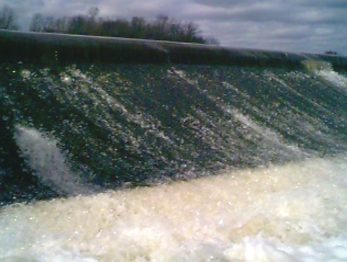
| Algonquin Dam, Algonquin
The dam is just past the Chicago Street(Route 62) bridge. Move over to river left BEFORE bridge, take out just before bridge and carry down past dam and continue your trip. |
 |
321.0 | 10.5 |
42 09.920N 88 17.437W [Tiger] [Mapquest] [Topozone] |
| Carpentersville Dam, Carpentersville
Watch horizon line of dam or small gazebo type building at dam on river right in case you miss the warning sign on river right. Move to river right and cross the earth berm away from the dam |
 |
316.6 | 9.0 |
42 06.843N 88 17.601W [Tiger] [Mapquest] [Topozone] |
| Elgin Dam, Elgin
Located just after Kimball Street bridge in Elgin. Not an easy portage. Before reaching the bridge move over as far as you can river left (east). Get out of your boat and use your painter line to control it while you walk under the bridge. There have been many fatalities at this dam. DO NOT RUN THIS DAM!. After you walk under bridge, carry your boat on the dirt trail by the Elgin Civic Center to get back down to the river past the dam |
 |
310.4 | 13.0 |
42 02.486N 88 17.300W [Tiger] [Mapquest] [Topozone] |
| South Elgin Dam, South Elgin
Just north of the State Street Bridge, in the town of South Elgin. Portage over earth berm on river right. Downstream of dam has a 2-3 foot cement wall along the water with a cement ledge at the low water mark. There is a easy place to step down after crossing berm just after the dam. |
 |
306.7 | 8.3 |
41 59.788N 88 17.698W [Tiger] [Mapquest] [Topozone] |
| North of IL 64, St Charles
Just north of Illinois 64. There are stairs river left before the dam for takeout, but I've been told that depending on the water levels in the Fox, the stairs on the other side of the dam at the put in can be in the boil of the dam. Great care must be used. Scout first. |
 |
299.3 | 10.0 |
41 54.821N 88 18.833W [Tiger] [Mapquest] [Topozone] |
| North of IL 38, Geneva
Portage river left onto bike path around dam |
 |
297.3 | 13.0 |
41 53.291N 88 18.079W [Tiger] [Mapquest] [Topozone] |
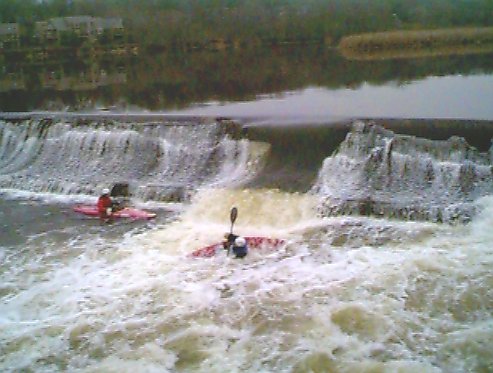
| North of Wilson Street, Batavia
I have not been in the water in this section of the Fox, however, after visiting via car on a scouting mission, there are gravel trails on river right for portage. River left has a broken section being used by kayakers to play in (as the photo shows). Scout first and don't play alone! |
 |
294.9 | 12.0 |
41 51.360N 88 18.490W [Tiger] [Mapquest] [Topozone] |
| Railroad Pier Dam, Batavia
Portage river left (before concrete pier, longer walk, lower bank, after concrete shorter walk, steeper bank) onto bike trail and continue straight when bike path turns and dirt trail leads to bottom of dam |
 |
294.2 | 5.0 |
41 50.200N 88 18.575W [Tiger] [Mapquest] [Topozone] |
| North of Butterfield Road, North Aurora
Portage river left through parkway area |
 |
291.3 | 9.0 |
41 48.438N 88 19.462W [Tiger] [Mapquest] [Topozone] |
| Casino Boat Dam East, Aurora
No portage at this Riverboat area, portage at West Dam |
 |
287.7 | 11.5 |
41 45.479N 88 18.852W [Tiger] [Mapquest] [Topozone] |
| Casino Boat Dam West, Aurora
Riverboat area, There is a canoe chute, but it is boarded up. Take out near the chute and carry down the concrete path which follows the chute down to rivers edge past the chute. |
 |
287.7 | 15.0 |
41 45.546N 88 18.852W [Tiger] [Mapquest] [Topozone] |
| North Ave Dam, Aurora
Odd portage. I took river lefts small strip of grass next to flood wall. Hold painter line and let boat over dam while you walk along edge. I saw no other way to portage this without walking for blocks. |
 |
287.2 | 1.5 |
41 45.191N 88 19.363W [Tiger] [Mapquest] [Topozone] |
| Montgomery
An strip of land separates the section with the dam and a section with an earth berm, little current and a small sluice gate. If you go river left into the earth berm section you can portage straight across the berm end without problem at the gauging station. |
 |
285.7 | 8.0 |
41 43.975N 88 20.073W [Tiger] [Mapquest] [Topozone] |
| Yorkville
Just east of the Main Street Bridge. The dam creates an unusual trough sometimes at its base and has claimed more than 13 lives, use extreme care if wading near this dam. Easy portage river left through city park |
 |
275.5 | 7.0 |
41 38.547N 88 26.590W [Tiger] [Mapquest] [Topozone] |
| Dayton
1/2 mile north of Dayton Road Bridge Portage river left just as stated on upstream warning sign. Beware of river right sluice gate which runs through power generator! |
 |
244.8 | 38.0 |
41 23.104N 88 47.398W [Tiger] [Mapquest] [Topozone] |
![[Topozone]](http://www.topozone.com/map.asp?lat=42.3091&lon=-88.2513&s=25&u=1&sym=http://pages.ripco.net/%7ejwn/info.gif&symx=13)
![[Topozone]](http://www.topozone.com/map.asp?lat=42.1658&lon=-88.2895&s=25&u=1&sym=http://pages.ripco.net/%7ejwn/info.gif&symx=13)
![[Topozone]](http://www.topozone.com/map.asp?lat=42.1145&lon=-88.2923&s=25&u=1&sym=http://pages.ripco.net/%7ejwn/info.gif&symx=13)
![[Topozone]](http://www.topozone.com/map.asp?lat=42.0413&lon=-88.2891&s=25&u=1&sym=http://pages.ripco.net/%7ejwn/info.gif&symx=13)
![[Topozone]](http://www.topozone.com/map.asp?lat=41.9955&lon=-88.2940&s=25&u=1&sym=http://pages.ripco.net/%7ejwn/info.gif&symx=13)
![[Topozone]](http://www.topozone.com/map.asp?lat=41.9147&lon=-88.3139&s=25&u=1&sym=http://pages.ripco.net/%7ejwn/info.gif&symx=13)
![[Topozone]](http://www.topozone.com/map.asp?lat=41.8882&lon=-88.3016&s=25&u=1&sym=http://pages.ripco.net/%7ejwn/info.gif&symx=13)
![[Topozone]](http://www.topozone.com/map.asp?lat=41.8545&lon=-88.3075&s=25&u=1&sym=http://pages.ripco.net/%7ejwn/info.gif&symx=13)
![[Topozone]](http://www.topozone.com/map.asp?lat=41.8367&lon=-88.3096&s=25&u=1&sym=http://pages.ripco.net/%7ejwn/info.gif&symx=13)
![[Topozone]](http://www.topozone.com/map.asp?lat=41.8072&lon=-88.3241&s=25&u=1&sym=http://pages.ripco.net/%7ejwn/info.gif&symx=13)
![[Topozone]](http://www.topozone.com/map.asp?lat=41.7577&lon=-88.3134&s=25&u=1&sym=http://pages.ripco.net/%7ejwn/info.gif&symx=13)
![[Topozone]](http://www.topozone.com/map.asp?lat=41.7585&lon=-88.3150&s=25&u=1&sym=http://pages.ripco.net/%7ejwn/info.gif&symx=13)
![[Topozone]](http://www.topozone.com/map.asp?lat=41.7531&lon=-88.3225&s=25&u=1&sym=http://pages.ripco.net/%7ejwn/info.gif&symx=13)
![[Topozone]](http://www.topozone.com/map.asp?lat=41.7348&lon=-88.3333&s=25&u=1&sym=http://pages.ripco.net/%7ejwn/info.gif&symx=13)
![[Topozone]](http://www.topozone.com/map.asp?lat=41.6433&lon=-88.4434&s=25&u=1&sym=http://pages.ripco.net/%7ejwn/info.gif&symx=13)
![[Topozone]](http://www.topozone.com/map.asp?lat=41.3869&lon=-88.7892&s=25&u=1&sym=http://pages.ripco.net/%7ejwn/info.gif&symx=13)
Illinois River | ||||
| Distances in the table below are from the mouth of the Illinois River where it meets the Mississippi River. | ||||
| Nearest City | Picture | River Mile | Dam Height (in feet) |
GPS Position |
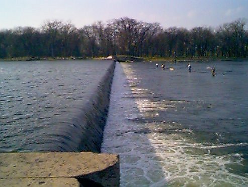
| Dresden Lock & Dam, Will County
Lock is river left. An alternative to waiting for the lock is to portage river right before the dam to the I&M Canal to pass the dam. There are many places to re-enter the river, the easiest being Stratton State Park. |
 |
271.5 | 21.75 |
41 23.945N 88 16.567W [Tiger] [Mapquest] [Topozone] |
| Marseilles Dam, Marseilles
Easy to spot navigation dam with tall peaked bridge just past dam. The dam is located on the main river channel, there is a channel on river left which has a lock about .5 miles away. Do not take small channel on river right as it runs thru a sluice to generate power.An alternative to waiting for the lock is to portage through Illini State Park on river left (but it's a long walk). |
 |
246.0 | 24.25 |
41 19.310N 88 42.525W [Tiger] [Mapquest] [Topozone] |
| Marseilles Lock, Marseilles
Easy to spot navigation dam with tall peaked bridge just past dam. The lock is located in the Marseilles Canal on river left. An alternative to waiting for the lock would be to portage through Illini State Park on river left , but the banks are steep |
 |
247.0 | 24.25 |
41 19.310N 88 42.525W [Tiger] [Mapquest] [Topozone] |
| Starved Rock Lock & Dam, Utica
Easy to spot navigation dam with cliffs of Starved Rock on river left. Lock is river right. An alternative to waiting for the lock is to portage river right before the lock at Dee Bennett Road and portage down road. |
 |
231.0 | 19.3 |
41 19.442N 88 59.055W [Tiger] [Mapquest] [Topozone] |
| Peoria Lock & Dam | 157.8 | 11.0 | ||
| LaGrange Lock & Dam | 80.0 | 10.0 | ||
![[Topozone]](http://www.topozone.com/map.asp?lat=41.3991&lon=-88.2762&s=25&u=1&sym=http://pages.ripco.net/%7ejwn/info.gif&symx=13)
![[Topozone]](http://www.topozone.com/map.asp?lat=41.3230&lon=-88.7095&s=25&u=1&sym=http://pages.ripco.net/%7ejwn/info.gif&symx=13)
![[Topozone]](http://www.topozone.com/map.asp?lat=41.3282&lon=-88.7530&s=25&u=1&sym=http://pages.ripco.net/%7ejwn/info.gif&symx=13)
![[Topozone]](http://www.topozone.com/map.asp?lat=41.3228&lon=-88.9873&s=25&u=1&sym=http://pages.ripco.net/%7ejwn/info.gif&symx=13)
Illinois & Michigan Canal | |||||
| Distances in the table below are from where the I&M canal meets the Illinois River. The I&M Canal meets the Illinois River 223.2 miles from the mouth of the Illinois River at the Mississippi. | |||||
| Lock #, City | Picture | River Mile | Dam Height (in feet) |
GPS Position | |
| Lock #15, LaSalle Lock is Submerged, no portage needed |
223.8 | 0 | Submerged | ||
| Lock #14, LaSalle Presently under construction, Ideal portage side is canal left thru I&M park, but no reason to portage unless you want to hike to the Illinois river, Steamboat basin (on other side of lock is a mud flat now) |
224.2 | 16.0 |
41 19.571N 89 05.789W [Tiger] [Mapquest] [Topozone] |
||
| Lock #8, Aux Sable The canal goes over Aux Sable Creek via an Aqueduct which you can paddle or ride over.Portage canal left, beware of sluice gates on canal right |
 |
267.5 | 16.0 |
41 23.755N 88 19.929W [Tiger] [Mapquest] [Topozone] |
|
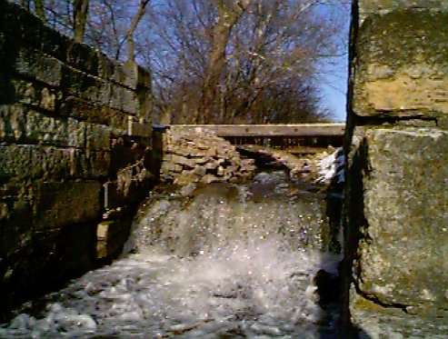
| Lock #7, Channahon Portage canal left over gravel berm to avoid sluice gates, but beware of DuPage River Dam! |
 |
276.9 | 16.0 |
41 25.286N 88 13.717W [Tiger] [Mapquest] [Topozone] |
|
| Lock #6, Channahon Portage canal left to DuPage river, (beware of DuPage dam!) or carry across bike bridge |
 |
277.2 | 10.0 |
41 25.400N 88 13.728W [Tiger] [Mapquest] [Topozone] |
|
![[Topozone]](http://www.topozone.com/map.asp?lat=41.3262&lon=-89.0965&s=25&u=1&sym=http://pages.ripco.net/%7ejwn/info.gif&symx=13)
![[Topozone]](http://www.topozone.com/map.asp?lat=41.3959&lon=-88.3321&s=25&u=1&sym=http://pages.ripco.net/%7ejwn/info.gif&symx=13)
![[Topozone]](http://www.topozone.com/map.asp?lat=41.4212&lon=-88.2290&s=25&u=1&sym=http://pages.ripco.net/%7ejwn/info.gif&symx=13)
![[Topozone]](http://www.topozone.com/map.asp?lat=41.4231&lon=-88.2284&s=25&u=1&sym=http://pages.ripco.net/%7ejwn/info.gif&symx=13)
Kankakee River | ||||
| Distances in the table below are from the mouth of the Illinois River. The Kankakee River meets the Illinois River 273.0 miles from the mouth of the Illinois River at the Mississippi. | ||||
| Name, City | Picture | River Mile | Dam Height (in feet) |
GPS Position |
| Wilmington Dam, Wilmington
Located just east of Route 53 bridge.Stay on main river channel (left of island) and avoid the small river right channel and sluice gate to the east. Portage through city park on river right (of river left channel). |
 |
282.5 | 5.0 |
41 18.020N 88 09.004W [Tiger] [Mapquest] [Topozone] |
| Kankakee Dam, Kankakee
Just west of arched rail bridge, located next to Illinois Route 50 bridge Nasty portage from boat ramp on river right to next opening in cement wall .75 miles away. |
 |
302.0 | 18.0 |
41 06.833N 87 52.069W [Tiger] [Mapquest] [Topozone] |
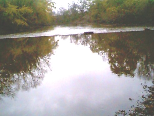
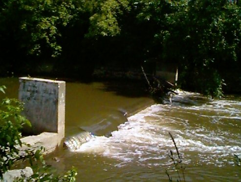
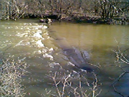
| Aroma Park Dam Breach, Aroma Park
Located just east of the Kankakee River Railroad Bridge in Aroma Park No portage needed. Breach area on river left (south). Note that this picture was taken from the island in the center of the river and the remaining dam covers roughly 30 percent of the northern river. |
 |
307.0 | 1.0 |
41 04.536N 87 48.151W [Tiger] [Mapquest] [Topozone] |
| Momence Dam, Momence
Located just west of Illinois Route 1 bridge Portage river right at Momence Police Department |
 |
316.0 | 3.0 |
41 09.697N 87 39.844W [Tiger] [Mapquest] [Topozone] |
![[Topozone]](http://www.topozone.com/map.asp?lat=41.3025&lon=-88.1508&s=25&u=1&sym=http://pages.ripco.net/%7ejwn/info.gif&symx=13)
![[Topozone]](http://www.topozone.com/map.asp?lat=41.1134&lon=-87.8677&s=25&u=1&sym=http://pages.ripco.net/%7ejwn/info.gif&symx=13)
![[Topozone]](http://www.topozone.com/map.asp?lat=41.0756&lon=-87.8025&s=25&u=1&sym=http://pages.ripco.net/%7ejwn/info.gif&symx=13)
![[Topozone]](http://www.topozone.com/map.asp?lat=41.1614&lon=-87.6640&s=25&u=1&sym=http://pages.ripco.net/%7ejwn/info.gif&symx=13)
Rock River | ||||
| Distances in the table below are from the mouth of the Rock River. Unlike most of the other rivers covered, the Rock River meets the Mississippi River river directly rather than flow thru the Illinois River. | ||||
| Name, City | Picture | River Mile | Dam Height (in feet) |
GPS Position |
| Rockton Dam, Rockton | ||||
| Fordham Dam, Rockford
Located just after arched bridge. Lowhead dam on each edge with U.S. ACE style wicket gates in center. Marked with white warning buoys and has a lifeline/red buoy line just before the dam. We didn't find a easy portage. There are two possible take out spots, river left at the powerboat ramp is less recommended than river right at the floating dock at Beattie Park. From Beattie Park, carry down Illinois 2 to the small street just before the railroad tracks (the train bridge is just after the dam). It's not easy to get back in the water here, but it's possible. For a slightly longer carry, turn left at the street after the tracks for easier access to the water, but it's a privately owned parking lot and we weren't sure how the owners would feel. |
 |
15.0 |
42 15.945N 89 05.815W [Tiger] [Mapquest] [Topozone] |
|
| Oregon Dam, Oregon
Located just before road bridge and marked with Buoys. We recommend portage on river left (east bank) thru city park. Take out before buoys, carry down across grass to parking lot, then down paved trail to other side of dam. There are bathrooms at this site also. |
 |
8.0 |
42 00.945N 89 19.760W [Tiger] [Mapquest] [Topozone] |
|
| Dixon Dam, Dixon
Located just east of Illinois Route 26 bridge. This is a power generating dam and has warning buoys and an additional lifeline buoy system upstream. Portage river right before buoys. You will have to carry on paved walkway under bridge to reach stairs. 1st set of stairs is only usable during high water, but the second set is much nicer and usable during any water level. This is a long portage |
 |
11.0 |
41 50.864N 89 29.048W [Tiger] [Mapquest] [Topozone] |
|
| Upper Sterling Dam, Sterling/Rock Falls
Located just west of the Hennepin Feeder Canal entrance. This is a power generating dam and has warning buoys and an additional lifeline buoy system upstream. The dam has a sign indicating that an alarm will sound when the power station increases its draw. Portage river left at Hennepin Canal Ramp. You will have to carry on paved walkway over bridge to reach city park after power station. This is a long portage |
 |
12.0 |
41 47.234N 89 40.647W [Tiger] [Mapquest] [Topozone] |
|
| Lower Sterling Dam, Sterling/Rock Falls
Located just west of the 1st Avenue Bridge. This dam has warning buoys and an additional lifeline buoy system upstream. Portage dam by paddling to the river left boat ramp (just upstream of dam). This is a short portage thru parking lot. |
 |
10.0 |
41 46.967N 89 41.665W [Tiger] [Mapquest] [Topozone] |
|
| Milan Steel Dam, Milan Low dam marked by warning sign on river left We recommend portaging into Hennepin Canal before dam at warning sign. Stay in canal past rapids at bridge (canal empties into Mississippi 1.5 miles away) |
 |
1.5 | 4.0 (est) |
41.4612694N 90.5487900W [Tiger] [Mapquest] [Topozone] |
| Sears Dam, Rock Island Avoid this dam on north side of island. Portage at Milan Steel Dam instead. |
 |
1.0 | 10.0 (est) |
41.4616013N 90.5783997W [Tiger] [Mapquest] [Topozone] |
![[Topozone]](http://www.topozone.com/map.asp?lat=42.2653&lon=-89.0950&s=25&u=1&sym=http://pages.ripco.net/%7ejwn/info.gif&symx=13)
![[Topozone]](http://www.topozone.com/map.asp?lat=42.0164&lon=-89.3273&s=25&u=1&sym=http://pages.ripco.net/%7ejwn/info.gif&symx=13)
![[Topozone]](http://www.topozone.com/map.asp?lat=41.8464&lon=-89.4812&s=25&u=1&sym=http://pages.ripco.net/%7ejwn/info.gif&symx=13)
![[Topozone]](http://www.topozone.com/map.asp?lat=41.7890&lon=-89.6782&s=25&u=1&sym=http://pages.ripco.net/%7ejwn/info.gif&symx=13)
![[Topozone]](http://www.topozone.com/map.asp?lat=41.7846&lon=-89.6939&s=25&u=1&sym=http://pages.ripco.net/%7ejwn/info.gif&symx=13)
![[Topozone]](http://www.topozone.com/map.asp?lat=41.4612694&lon=-90.5487900&s=25&u=1&sym=http://pages.ripco.net/%7ejwn/info.gif&symx=13)
![[Topozone]](http://www.topozone.com/map.asp?lat=41.4616013&lon=-90.5783997&s=25&u=1&sym=http://pages.ripco.net/%7ejwn/info.gif&symx=13)
Nippersink Creek | ||||
| Distances in the table below are from the mouth of the Illinois River. Nippersink Creek meets the Fox River 346.65 miles from the mouth of the Illinois River at the Mississippi. | ||||
| Nearest City | Picture | River Mile | Dam Height (in feet) |
GPS Position |
| Wonder Lake Dam, Wonder Lake | 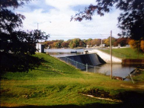 |
364.2 | 22.0 |
42 24.631N 88 19.231W [Tiger] [Mapquest] [Topozone] |
![[Topozone]](http://www.topozone.com/map.asp?lat=42.4104&lon=-88.3404&s=25&u=1&sym=http://pages.ripco.net/%7ejwn/info.gif&symx=13)
North Shore Sanitary Canal | ||||
| Distances in the table below are from the mouth of the Illinois River. The North Shore Sanitary Canal meets the Chicago River 333.6 miles from the mouth of the Illinois River at the Mississippi. | ||||
| Name, City | Picture | River Mile | Dam Height (in feet) |
GPS Position |
| Sluice Gate/Old Lock, Wilmette | 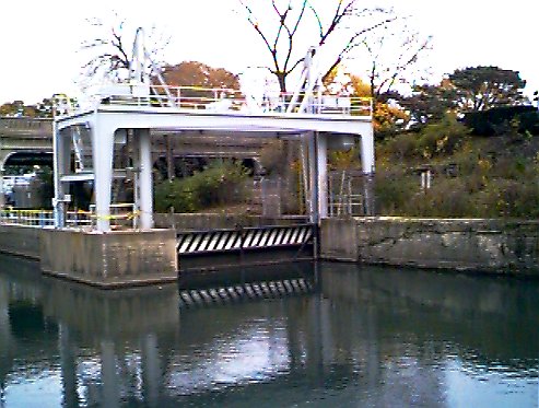 |
343.9 | 5.7 |
42 04.58N* 87 41.14W* [Tiger] [Mapquest] [Topozone] |
| North Branch Spillway CR dumping into NSSC, Chicago See Chicago River for more info |
|
333.6 | 4.0 |
41 58.436N 87 42.296W [Tiger] [Mapquest] [Topozone] |
![[Topozone]](http://www.topozone.com/map.asp?lat=42.0763&lon=-87.6840&s=25&u=1&sym=http://pages.ripco.net/%7ejwn/info.gif&symx=13)
![[Topozone]](http://www.topozone.com/map.asp?lat=41.9738&lon=-87.7049&s=25&u=1&sym=http://pages.ripco.net/%7ejwn/info.gif&symx=13)
Salt Creek (Incomplete) | ||||
| Distances in the table below are from the mouth of the Illinois River. Salt Creek meets the Des Plaines River 317 miles from the mouth of the Illinois. | ||||
| Nearest City | Picture | River Mile | Dam Height (in feet) |
GPS Position |
| Mud Dam/Drop This is where the dredging of the creek stopped, creating this 4 foot drop from the undredged section of the creek into the section dredged. |
||||
| Sheet Piling Dam, Villa Park
Portage is on creek left and is rather difficult. The shoreline and entire portage is all rocks that are not stable with various trees and shrubs. The dam actually has two sections, you can see the two sets of sheet pilings on the far shore. Photo/portage info/Google link courtesy Mike Link |
 |
1 (est) | 41.874127N 87.95628W [Tiger] [Mapquest] [Topozone] |
|
| Butler Nature Center Dam, Hinsdale Portage Creek left as area on right is occupied by many expensive homes, avoid sluice gates on right |
 |
330.25 | 3.0 |
41 49.805N 87 56.402W [Tiger] [Mapquest] [Topozone] |
| Graue Mill Dam, Hinsdale
50 yards west of York Road bridge No ramps, sluice gates on each side, I would portage creek right (south) as the Mill wheel sluice seems far more tame than the flood control sluice on the other side of the river, however, we once were going to launch from there and were told by a police officer that he didn't think we were supposed to canoe from here. (We started our trip downstream instead) Very dry dam. |
 |
327.0 | 4.0 |
41 49.230N 87 55.635W [Tiger] [Mapquest] [Topozone] |
| Possum Hollow, Westchester Dam with concrete posts that extend from the water when the water is low snagging boats. Portage river right |
 |
322.5 | 2.0 (est) |
41 50.242N 87 53.032W [Tiger] [Mapquest] [Topozone] |
![[Topozone]](http://www.topozone.com/map.asp?lat=41.874127&lon=-87.95628&s=25&u=1&sym=http://pages.ripco.net/%7ejwn/info.gif&symx=13)
![[Topozone]](http://www.topozone.com/map.asp?lat=41.8301&lon=-87.9402&s=25&u=1&sym=http://pages.ripco.net/%7ejwn/info.gif&symx=13)
![[Topozone]](http://www.topozone.com/map.asp?lat=41.8205&lon=-87.9273&s=25&u=1&sym=http://pages.ripco.net/%7ejwn/info.gif&symx=13)
![[Topozone]](http://www.topozone.com/map.asp?lat=41.8375&lon=-87.8829&s=25&u=1&sym=http://pages.ripco.net/%7ejwn/info.gif&symx=13)
Ship & Sanitary Canal | ||||
| Distances in the table below are from the mouth of the Illinois River. The Ship and Sanitary Canal meets the Illinois River 290 miles from the mouth of the Illinois River at the Mississippi. | ||||
| Nearest City | Picture | River Mile | Dam Height (in feet) |
GPS Position |
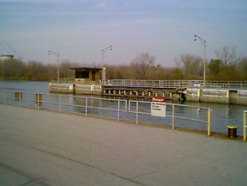
| Lockport Lock & Dam, Lockport
This lock is the only lock on the Illinois Waterway with dual straight drop gates at the upstream end and traditional mitered gates downstream. On the upstream side, they lower the gate several feet and let the water rush over the top instead of using pipes below water level. On the downstream side, the water runs through 6+ foot diameter pipes and is able to flush 22,000,000 gallons in 15 minutes when open full. |
 |
291.0 | 39.0 | |
| Beartrap Dam, Romeoville (outbound to Des Plaines River)
140th Street and Des Plaines River Drops into Des Plaines, no portage needed |
N/A | 293.15 | 8.0 |
41 35.856N 88 03.938W [Tiger] [Mapquest] [Topozone] |
![[Topozone]](http://www.topozone.com/map.asp?lat=41.5976&lon=-88.0656&s=25&u=1&sym=http://pages.ripco.net/%7ejwn/info.gif&symx=13)
Skokie River | ||||
| Distances in the table below are from the mouth of the Illinois River. The Chicago River meets the Ship and Sanitary Canal 321 miles from the mouth of the Illinois River at the Mississippi. Skokie River is also referred to as the East Fork, North Branch, Chicago River | ||||
| Name, City | Picture | River Mile | Dam Height (in feet) |
GPS Position |
| Willow Road Dam, Skokie Lagoons
East Fork, North Branch. Portage east or west as there are stairs on both sides. See Skokie Lagoons for more dam information |
|
10.0 |
42 06.119N 87 45.545W [Tiger] [Mapquest] [Topozone] |
|
| Winnetka Dam, Winnetka
East Fork, North Branch, Chicago River a.k.a. Skokie River 100 yards north of Winnetka Road bridge No ramps, steep banks, portage river left (east) to dirt trail and avoid the thicket on other side. |
|
351.5 | 2.0 |
42 05.668N 87 45.430W [Tiger] [Mapquest] [Topozone] |
![[Topozone]](http://www.topozone.com/map.asp?lat=42.1012&lon=-87.7593&s=25&u=1&sym=http://pages.ripco.net/%7ejwn/info.gif&symx=13)
![[Topozone]](http://www.topozone.com/map.asp?lat=42.0945&lon=-87.7572&s=25&u=1&sym=http://pages.ripco.net/%7ejwn/info.gif&symx=13)
Vermilion River | ||||
| Nearest City | Picture | River Mile | Dam Height (in feet) | GPS Position |
| Marquette Cement Company Dam There is a suspended sign over the river shortly before the dam. Boat Chute on river right, watch for rebar at bottom. Chute gets nastier as the water level drops |
N/A | ?.? | 3.0 | |
| Streator Dam | N/A | ?.? | 30.0 |
41 06.456N 88 50.936W [Tiger] [Mapquest] [Topozone] |
| Ladd Street Dam, Pontiac
50 yards west of Ladd Street Bridge.Muddy/messy portage on river right |
 |
?.? | 3.0 |
40 52.691N 88 38.385W [Tiger] [Mapquest] [Topozone] |
| Mill Street Dam, Pontiac
Just before bridge, white warning sign on river right as you pass city park which is on river left. Portage river left |
 |
?.? | 4.0 |
40 52.636N 88 37.818W [Tiger] [Mapquest] [Topozone] |
| Pontiac Dam | N/A | ?.? | ?.? | |
![[Topozone]](http://www.topozone.com/map.asp?lat=41.1058&lon=-88.8489&s=25&u=1&sym=http://pages.ripco.net/%7ejwn/info.gif&symx=13)
![[Topozone]](http://www.topozone.com/map.asp?lat=40.8782&lon=-88.6398&s=25&u=1&sym=http://pages.ripco.net/%7ejwn/info.gif&symx=13)
![[Topozone]](http://www.topozone.com/map.asp?lat=40.8780&lon=-88.6293&s=25&u=1&sym=http://pages.ripco.net/%7ejwn/info.gif&symx=13)
Lakes with Dams | |||
| These are individual lakes, some may be connected to streams, some may not. No mileage is given. | |||
| Lake Name | Picture | Dam Height (in feet) |
GPS Position |
| Big Bend Spillway, Des Plaines
Easy portage on both sides of spillway if access to the Des Plaines River is desired. |
 |
6.0 |
42 02.947N 87 52.399W [Tiger] [Mapquest] [Topozone] |
| Busse North Dam, Elk Grove No portage needed, boats are not allowed in north pond |
 |
3.0 |
42 01.83N* 88 01.23W* [Tiger] [Mapquest] [Topozone] |
| Busse South Dam, Elk Grove
We used to portage on the south side but found it too shallow during low water. Portage on north side of dam results in less scars on boat |
 |
4.0 |
42 01.25N* 88 01.91W* [Tiger] [Mapquest] [Topozone] |
| Main Dam, Busse Lake, Elk Grove | 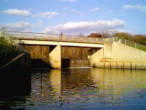 |
12.0 |
42 00.83N* 88 00.00W* [Tiger] [Mapquest] [Topozone] |
| Lake in the Hills Dam, Lake in the Hills | 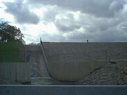 |
12.0 |
42 10.775N 88 19.068W [Tiger] [Mapquest] [Topozone] |
| Saganashkee Slough Dam, Palos Park Runs down a drainage tube to Cal-Sag Channel |
 |
12.0 |
41 41.324N 87 52.515W [Tiger] [Mapquest] [Topozone] |
| Spring Lake Dam, Aurora Part of Waubansee (Waubonsie) Creek |
 |
3.0 |
41 45.267N 88 13.822W [Tiger] [Mapquest] [Topozone] |
| Earth Dike and Culvert, Skokie Lagoons
If you're in the area, explore this island. There was a Nike Missile base here during the Cold War. The missiles were eliminated by the Salt Treaties. Other former Nike bases are located at Wolf Lake and the Cal-Sag. Because of the industrial nature of the Chicago Area (at one time, the most industrialized in the world), Chicago was one of a select few cities to receive updated Nikes with nuclear warheads. |
 |
0.0 |
42 07.817N 87 46.761W [Tiger] [Mapquest] [Topozone] |
| Voltz Road/Glencoe Dam, Skokie Lagoons
Landing on left (west) side |
 |
2.0 |
42 07.630N 87 46.593W [Tiger] [Mapquest] [Topozone] |
| Pine Street Dam, Skokie Lagoons
Landing on right (west), low banks on east, your choice |
 |
2.0 |
42 06.664N 87 45.913W [Tiger] [Mapquest] [Topozone] |
| Tower Road Dam, Skokie Lagoons
Boat landing on right (west) with padded pull ramp |
 |
2.0 |
42 07.002N 87 46.441W [Tiger] [Mapquest] [Topozone] |
| Willow Road Dam, Skokie Lagoons
Portage east or west as there are stairs on both sides |
|
10.0 |
42 06.119N 87 45.545W [Tiger] [Mapquest] [Topozone] |
| Tampier Lake Dam, Orland Park No portages, there is little water in creek below |
 |
10.0 |
41 38.778N 87 54.475W [Tiger] [Mapquest] [Topozone] |
| Wonder Lake Dam, Wonder Lake
Note: This photo was provided by Dan Stopka. |
|
22.0 |
42 24.631N 88 19.231W [Tiger] [Mapquest] [Topozone] |
![[Topozone]](http://www.topozone.com/map.asp?lat=42.0493&lon=-87.8754&s=25&u=1&sym=http://pages.ripco.net/%7ejwn/info.gif&symx=13)
![[Topozone]](http://www.topozone.com/map.asp?lat=42.0312&lon=-88.0191&s=25&u=1&sym=http://pages.ripco.net/%7ejwn/info.gif&symx=13)
![[Topozone]](http://www.topozone.com/map.asp?lat=42.0226&lon=-88.0091&s=25&u=1&sym=http://pages.ripco.net/%7ejwn/info.gif&symx=13)
![[Topozone]](http://www.topozone.com/map.asp?lat=42.0166&lon=-88.0003&s=25&u=1&sym=http://pages.ripco.net/%7ejwn/info.gif&symx=13)
![[Topozone]](http://www.topozone.com/map.asp?lat=42.1796&lon=-88.3178&s=25&u=1&sym=http://pages.ripco.net/%7ejwn/info.gif&symx=13)
![[Topozone]](http://www.topozone.com/map.asp?lat=41.6895&lon=-87.8757&s=25&u=1&sym=http://pages.ripco.net/%7ejwn/info.gif&symx=13)
![[Topozone]](http://www.topozone.com/map.asp?lat=41.7547&lon=-88.2304&s=25&u=1&sym=http://pages.ripco.net/%7ejwn/info.gif&symx=13)
![[Topozone]](http://www.topozone.com/map.asp?lat=42.1278&lon=-87.7768&s=25&u=1&sym=http://pages.ripco.net/%7ejwn/info.gif&symx=13)
![[Topozone]](http://www.topozone.com/map.asp?lat=42.1240&lon=-87.7740&s=25&u=1&sym=http://pages.ripco.net/%7ejwn/info.gif&symx=13)
![[Topozone]](http://www.topozone.com/map.asp?lat=42.1110&lon=-87.7662&s=25&u=1&sym=http://pages.ripco.net/%7ejwn/info.gif&symx=13)
![[Topozone]](http://www.topozone.com/map.asp?lat=42.1171&lon=-87.7748&s=25&u=1&sym=http://pages.ripco.net/%7ejwn/info.gif&symx=13)
![[Topozone]](http://www.topozone.com/map.asp?lat=41.6456&lon=-87.9087&s=25&u=1&sym=http://pages.ripco.net/%7ejwn/info.gif&symx=13)
GPS Position taken via Garmin 12 GPS using Datum WGS84 unless notes below
* GPS Position taken via Magellan GPS 2000 using Datum WGS84
All photos unless otherwise noted are Chicago Paddling/Fishing Page originals and must not be reproduced without permission
| Home | Fishing | Sailing | Canoeing | Rowing | Printing |
| Please e-mail suggestion/comments to: jwn@ripco.com | |||||