| Des Plaines River
(Cook, DuPage, Will Counties, Illinois, U.S.A.) |
| We are not responsible for errors or omissions. When boating, regardless of water depth, wear a PFD! |
| Des Plaines River
(Cook, DuPage, Will Counties, Illinois, U.S.A.) |
| We are not responsible for errors or omissions. When boating, regardless of water depth, wear a PFD! |
| River History |
From its beginning, the water in the Des Plaines hasn't been exactly sure where it belongs. The Des Plaines shares its swampy headwaters in the swamps between Racine and Kenosha, with the Root River. The Root River flows into the Great Lakes Watershed, the Des Plaines (which once flowed into the Great Lakes Watershed) flows into the Mississippi Watershed.
During the last ice age, when ice covered much of the north, the Des Plaines River flowed into what we refer to as Lake Chicago right near the present site of the Hoffman Dam. With the St Lawrence blocked by glaciers, several great outlet rivers formed to drain the water melting from the glaciers. One such outlet was about 1 mile south of where the Des Plaines River emptied into Lake Chicago. If you were to travel down Interstate 294 between 83rd street and 75th street, you'll travel across a large valley and long bridge. That bridge crosses the once great outlet channel. The channel was once filled edge to edge with water draining from the melting glaciers. As the glacial periods ended, the Des Plaines continued to flow into the retreating Lake Michigan until the levels of the area known as Lake Chicago dropped beyond the present location of Kedzie Avenue. Just east of Kedzie, there is a small ridge. This ridge is only about 11 feet higher than the surrounding area and runs all the way to Lake Superior, staying about 10 to 15 miles west of the Great Lakes separating the Great Lakes Watershed from the Mississippi Watershed.
As the lake receded past Kedzie, a large swamp (called Mud Lake) developed
in the area where the water couldn't pass over the ridge. Eventually, the
river snaked its way back thru the great outlet valley to meet the Illinois
River just south of Channahon.
![[Chicago Divide Map]](charea.gif)
In 1848, the Illinois and Michigan Canal was dug thru the southernmost section of the valley. Soon the I&M canal wasn't large enough for shipping needs, so plans were made for a new canal. In 1894, the newly formed Sanitary District began channelizing the wandering bends of the Des Plaines in the outlet valley to permit digging of the Ship and Sanitary Canal. If you begin to travel south from Stoney Ford, once you pass the railroad bridge, you are in the new channelized river. The river is channelized for most of the way except for a few places (I have maps that I will get online shortly), Only after the river makes its turn to the south (just north of Romeoville) is the river back in its own channel.
![[Des Plaines/Mud Lake Map]](chport.gif)
Above map is of the portage area showing Ogden ditch and I&M Canal
![[Des Plaines Map]](despbend.gif)
The above map shows the start of the diversion channel. If you look at the picture below (it's from just inside the start of the channel), you can see the old pillars from the previous bridge between the new bridge pillars.
![[Des Plaines Pic]](despbend.jpg)
| Home | Fishing | Sailing | Canoeing | Rowing | Printing |
| Please e-mail suggestion/comments to: jwn@ripco.com | |||||
| Recent Updates |
4/14 Someone ran the Hoffman dam... They both survived.
9/01 Annual Labor Day trip: Lots and lots of people on the river! I was pleased to see Caspias, Kolpas, Fotbots, a Klepper, Old Towns, and several Aluminum canoes as well on the river. I've never seen so much traffic on the river.
8/25 On one of my previous trips on this river I encountered a power boat south of Stony Ford. I was very surprised as I had always thought that this section of the river was hand carry launch only. Well, today, I found the source of the powerboat. Burr Ridge Park District has built a trailorable boat ramp just off Madison street, just south of 97th street. It's right near the DuPage County Waste Treatment Plant. The ramp is gravel both above and below the water level and is free. Limited parking is available. To get to this ramp, take Madison to just before it dead ends and turn left toward the sewage treatment plant. At the "T" intersection turn right (the sewage plant is on the left) and follow it straight down to the edge of the river.
| General Information |
The Des Plaines River travels generally due south from the Wisconsin border. The river makes a few turns, generally to the east, such as the "Big Bend" near Oakton Community College in the town of Des Plaines. But the southerly course prevails until Plank Road Woods in Lyons. At "Plank Road" (better known as Ogden Avenue these days), Salt Creek (once known as the West Fork of the Des Plaines River) joins the Des Plaines, and the river turns east, crossing the Hoffman Dam. The river then almost forms an ox-bow, turning northeast, northwest, and southeast, and then south again near Stony Ford Woods (also in Lyons).
The Des Plaines is then channelized and turns southwest again a short while later, running parallel to and just north of the Chicago Ship and Sanitary Canal and the Stevenson Expressway (I-55). The river continues southwest through Lemont, then turns south back to its original channel near Romeoville. The river continues south through Joliet, then turns southwest until it merges with the DuPage River, and then the Kankakee River to form the Illinois River.
The Des Plaines River can be divided into sections with distinctly different personalities. The section above Lyons is a mostly narrow river, twisting and turning its way to the south. Between Lyons and Lockport, the river is non-navigable and mostly channelized. Except for the areas between the Hoffman Dam and the North Avenue Dam, and the Burr Ridge Ramp and the rail bridge, there isn't a place for trailered motorboats to be put in the river.
Above the Hoffman Dam, the river is deeper, slow moving, with little current. Below the dam, the river is much shallower. At Stony Ford and Lawson Fords, you can walk across the river. The land adjoining the non-navigable portion of the river is mostly forested and includes many forest preserves. One notable exception to this is in the city of Riverside, where many homes are located right near the waterway. (Ironically, Riverside also uses volunteers each spring help sandbag the area.)
The non-navigable section above Lyons contains a series of low-head dams for flood control, the largest of these being the Hoffman Dam. After the Hoffman Dam, there are no more dams until you reach Rockdale's Brandon Road Dam (a very large dam with locks) which is in the navigable portion of the river.
The river's long southwest stretch can be tiresome at times. The world's largest waste treatment plant, the MWRD Stickney plant, is located right alongside the river and depending on the wind, contributes considerable odor to the area. Also, the Ship and Sanitary Canal runs alongside the river, less than 100 yards away and can contribute sewage odor and noise from powercraft and barges.
As the river takes its turn south near Romeoville, it forms a large pool with un-river like characteristics. Instead of moving current and waves standing still, it takes on lake like waves. The river becomes quite wide and shallow. Shortly after you exit the large pool (about 1 mile long), a large island will appear in the center. This is Isle a la Cache nature center. If you travel to the right, you'll find a museum and canoe launch where you can stop (if the museum is open) and get fresh water and use the facilities. Isle a la Cache is the only remaining island on the river, the others (the largest of which was Prescott Island near Lyons/McCook) have had one of the rivers channels landfilled and are now covered with homes and roadways. The original pioneers wrote of the Isle as a landmark in their logs and should you stop there, you will no doubt be following the footsteps of many before you.
Beyond the Isle, a series of sluice gates connect overflow from the Ship and Sanitary Canal to the Des Plaines river, increasing the river's flow. At this point,the river also begins its 20-foot drop to the level of the Ship and Sanitary Canal. The river and the canal join south of the Lockport Lock.
Just after you pass under the Illinois 7 bridge, a series of small islands appears. This area, due to the increased flow, rapid drop, and compression of the islands is called the Fishnet Rapids (the islands make a fishnet-like pattern, and the water flows rapidly).
Just past the rapids, the River joins the Ship and Sanitary Canal Channel. This section of the river is navigable and home to many power boats. As the river flows thru Joliet, large gambling casinos travel the river as well as river tugs, pushing their strings of barges. This section is very industrial, and most of the area has corrugated steel vertical walls, making take-out points hard to find. The sewage flow of the Chicago River and Ship and Sanitary Canal find their way into the Des Plaines River south of Lockport. This creates water that has a certain aroma to it, one that, especially when mixed with the smell of diesel, isn't pleasant. I haven't paddled this section of the river, but have watched it from the bridges. If you are near a barge tow, stay as far away from them as you can. They go thru the bridges by bouncing the barges off the wood piles and there is really no place to hide from them in the channel.
| River Access |
| There are two boat ramps that can accommodate trailered power boats: |
| Canoe/kayak only ramps at: (these are carry-in ramps) |
| River Pictures |
At the head of the diversion channel
![[dam150.gif]](dam.jpg)
The ominous-looking Hofmann Tower (Built in 1908 for George Hofmann) is located at the Hoffman dam, just down river from the Plank Woods ramp. (One shouldn't venture too close to the dam.)
![[refine15.jpg]](refine.jpg)
![[refine25.jpg]](refine2.jpg)
Oil refinery in Romeoville
![[heron150.jpg]](heron.jpg)
A Great Blue Heron (grey) near Isle a la Cache. Decent 24x zoom picture.
![[w200.jpg]](w2.jpg)
A White Egret north of Isle a la Cache. Another 24x zoom picture.
| Home | Fishing | Sailing | Canoeing | Rowing | Printing |
| Please e-mail suggestion/comments to: jwn@ripco.com | |||||
| River Maps |
| River Maps from Lockport to Illinois River |
New 1998 navigation maps are available at the U.S. Army Corps of Engineers' Navigation Information Connection (NIC) web site.
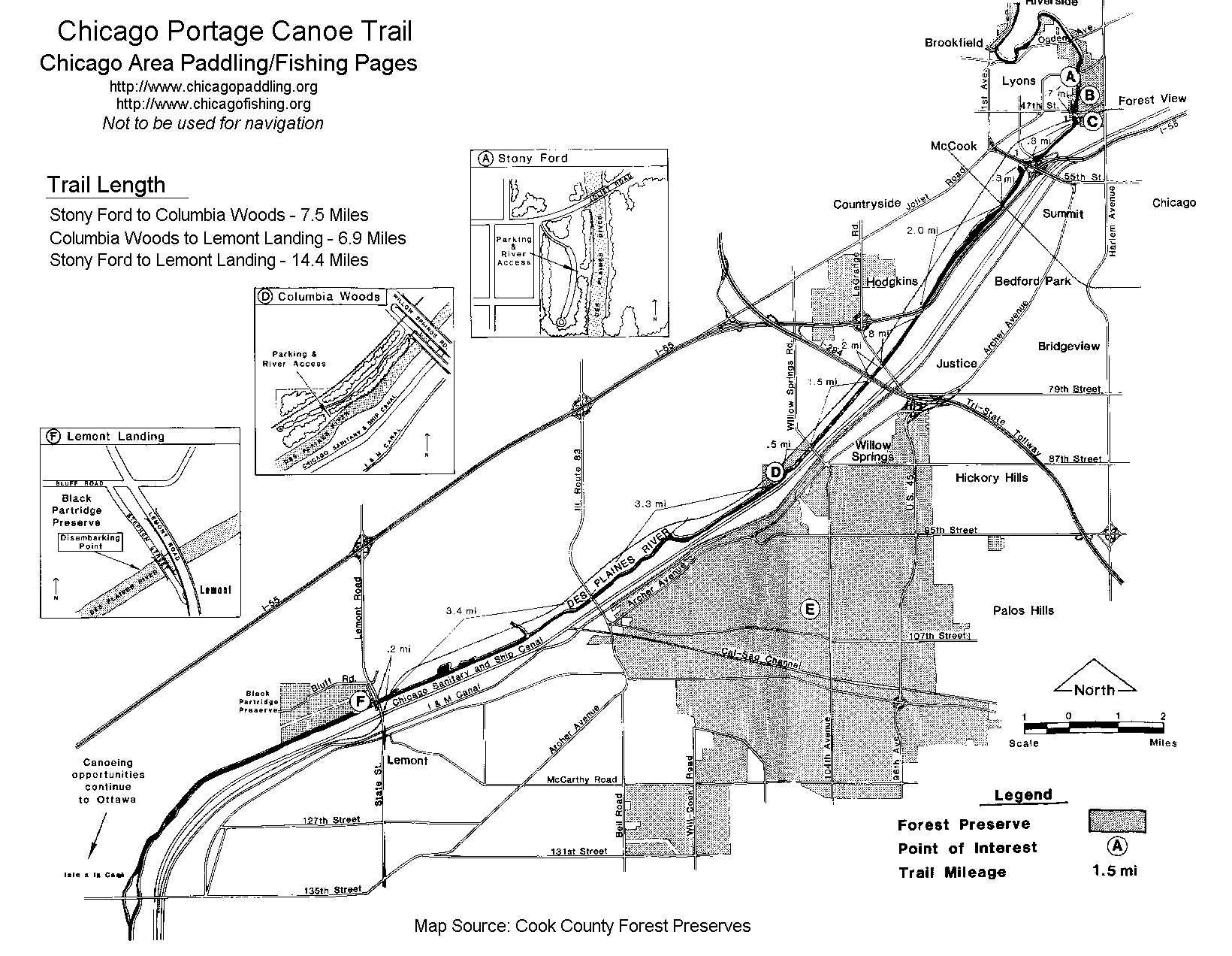
| Chicago Portage Canoe Trail |
The trail begins at Stony Ford in Lyons and the Chicago Portage Canoe Trail travels down the Des Plaines River to Lockport.
Trail points and distances are:
Note: This part of the river can be very shallow.
Boating information:
| Fish Information |
Fish in this River include:
| Trip Reports |
None at this time
| Home | Fishing | Sailing | Canoeing | Rowing | Printing |
| Please e-mail suggestion/comments to: jwn@ripco.com | |||||
| Water Quality |
Sewage Discharge into the Des Plaines (Based on 7 year, 0 day low reports from Illinois EPA)
Des Plaines River Water Quality Information (Illinois EPA)
| Home | Fishing | Sailing | Canoeing | Rowing | Printing |
| Please e-mail suggestion/comments to: jwn@ripco.com | |||||
![[portage.jpg]](portage.jpg)