| Chicago River
(Cook County, Illinois, U.S.A.) |
| We are not responsible for errors or omissions. When boating, regardless of water depth, wear a PFD! |
| Chicago River
(Cook County, Illinois, U.S.A.) |
| We are not responsible for errors or omissions. When boating, regardless of water depth, wear a PFD! |
| River History |
![[River Mouth 1906]](chicago1906.jpg)
(A 1906 Chicago Post Card showing the river mouth)
The Chicago River has been pushed, shoved, turned around and worse. The south branch has even had its flow reversed in its short existence. During the Tolleston Era of the ice age, the river was completely submerged by Lake Chicago. Later, as the St. Lawrence River freed itself from ice and opened, the lake would recede, and the river would slowly carve its channel into the ground. Much later, the river would gain fame as one of four portages into the interior of the nation.
| The Portages: |
The shifting of the Grand Calumet River mouth in 1804 eliminated that area as a portage, leaving the longer Green Bay, and St. Joe routes, or the shorter Chicago Portage. This helped push Chicago to be the center of commerce that it is today.
| The River: |
History tell us that the Chicago River never had a very strong flow, and that Lake Michigan often covered the river's mouth with sand, just as the lake still does today to the Dead River in northern Illinois. Probably its strongest flow ever was the day they opened the Ship and Sanitary Canal. Without locks at Chicago Harbor, the river rushed to fill the 25 foot deep, 28 mile long canal, reaching estimated flows of 300,000 cfm. At one point, a canal executive told a local newspaper reporter, "Look at the river, it's as blue as the sky!". The clean water would not last for long however, St. Louis wasn't very happy about Chicago sending its sewage their way, and Canada wasn't happy either about the diversion of so much Great Lakes water. After a series of court cases, the amount of water that can be drawn from Lake Michigan is now set by the U.S. Supreme Court. The river presently flows at a lazy pace of around 25 cfs (1500 cfm, or about 1/200th of the peak flow in 1900).
There have been a lot of changes on the Chicago River. Here is a general time line that I've found: (Note: The while the Illinois and Miami indians were from different tribes, the French considered them related in past history due to a common language and features.)
Myth: The Chicago River was the first natural body of water reversed.
Fact: The Chicago River was the third Chicago area river or creek to be reversed:
![[crbranch.gif]](crbranch.gif)
Soldiers from Fort Dearborn moved the mouth of the river from near Madison Street to its current location during spring floods in 1830.
![[Fort Dearborn]](fd1.gif)
Army Corps of Engineers plan of harbor and dam to close off original
mouth of the river.
The Chicago River has two main branches, the North Branch and the South Branch. Both branches also have several branches or forks of their own.
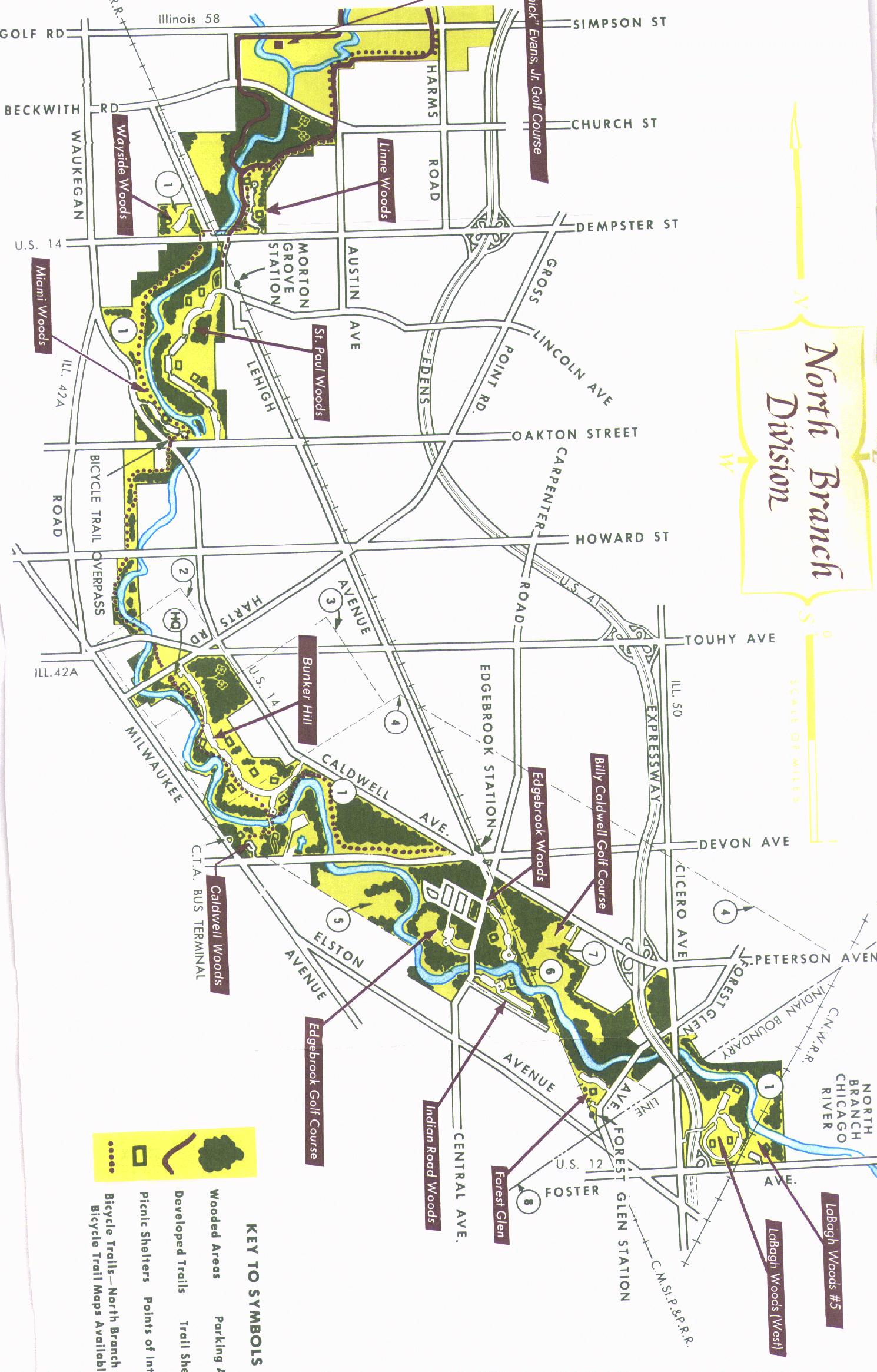
| The North Branch |
The North Branch's West Fork meets the North Branch just south of Golf Road, and the North Branches East Fork (or Skokie River) meets the North Branch just south of Winnetka Road.
The following maps show how the North Branch was moved and straightened in 1904 to accommodate shipping needs.
![[ River Map]](chir1.gif)
![[ River Map]](chir2.gif)
![[ River Map]](chir3.gif)
![[ River Map]](chir4.gif)
![[ River Map]](chir5.gif)
The maps below show the river in 1873, back when it had creeks and backwaters.
![[ River Map]](crcpna.gif)
![[ River Map]](crnads.gif)
| The South Branch: |
The South Branch of the Chicago River is presently made up of the South Branch itself and the South Fork which meet around Ashland. At one time however, there was a second fork (West) with it joining the river around Hoyne Ave.
![[South Fork Map]](sfork.gif)
Map of present day South Fork, South Branch, Chicago River
![[I&M Mouth Map]](chicagorivim.gif)
Map of junction of South Branch and I&M. While maps claims a 1899 date, the improvements listed were complete before the opening of the Ship and Sanitary Canal in 1900. Later, the area shown as Levee, Post and Water street would become the current turning basin (See above map).
![[River Map]](bubcreek.gif)
A 1910 map showing the real bubbly creek before it was filled in. They would toss in everything they didn't use when slaughtering animals at the stockyards. It was determined that the waterways were so polluted, the only thing to do was fill it in.
![[Area Map]](charea.gif)
![[hullmap.gif]](hull.gif)
A copy of General Hull's map. Hull was Governor of the Michigan territories.
| Updates |
4/23/98 Andersen Shrimp building has burnt down. Drove by there today.
8/98 There was a drowning on the Chicago at the Chicago Harbor Lock. A man was playing by jumping out of a boat to the lock wall, then jumping back in. Eventually he slipped, struck his head against the lock wall and fell into the water.
10/98 There is a new book called The Chicago River by David Solzman. I bought mine from Amazon.com. You may want to check it out for more info on the river. Make sure you read page 270! (It mentions this web site... ;-) (And no, I had no idea until I saw the listing that it was in there.)
The full publication information is: The Chicago River: An Illustrated History and Guide to the River and its Waterways. David M. Solzman. Wild Onion Books, Chicago, 1998. ISBN 0-8294-1023-6.
| General Information |
An easy river to paddle both with and against the current, the Chicago is a nice place to paddle. One must, however be ever mindful of a few problems. Barges, powerboats, wind, and dirty water are the most serious. Also, because much of the river has been channelized, 10+ foot high steel walls surround the river. This impedes access and rescue. If you tip in the river, you will have to rescue yourself (and this act may have to be performed under pressure of an approaching tug/barge if you are in the navigable channels). Pay close attention to the wind on days your going to the river as it becomes very strong in the channel at times. (I got caught by a 38 mph gust once in the barge channel and lost a lot of ground (water) finding a place to hide from the wind.)
| River Access |
There was a boat ramp at 55th Street and the Ship & Sanitary Channel that could accommodate trailered power boats. It is presently closed, however there are plans underway to reopen the ramp as well as a park as part of Summit's bid for a riverboat casino.
There are also Chicago Park District ramps at Burnham Harbor and Monroe harbors on Lake Michigan. You could launch at one of these ramps and then travel back through the Chicago Harbor locks for access to the river.
| Boating Information: |
| Canoe/Kayak access at: (carry-in dirt access) |
| River Pictures |
![[South Fork Pic]](sfork20.jpg)
A composite picture from the new park on the South Fork.
![[chi200.jpg]](chi2.jpg)
Chicago River's brown water, flowing around a bend.
![[chi100.jpg]](chi1.jpg)
Approaching the Central Street bridge at dusk.
![[Pillars?]](imp4.jpg)
![[Pillars?]](imp10.jpg)
![[More Pillars?]](imp20.jpg)
Interesting items along the riverbanks
![[Barges]](barge.jpg)
About to travel under the barge tunnel to cross the river.
![[Bridge]](criver.jpg)
Looking towards Archer, I-55, and a rail bridge near 28th and Ashland.
| River Maps |
| U.S. Army Corps of Engineers River Navigation Maps |
New 1998 navigation maps are available at the U.S. Army Corps of Engineers web site at http://www2.mvr.usace.army.mil/NIC2/ilwwcharts.cfm
| Cook County Forest Preserve Map |
| Historical Maps of the River |
The following maps show how the North Branch was moved and straightened
in 1904 to accommodate shipping needs.
Between Foster and Lawrence
Between Lawrence and Montrose
Between Montrose and Irving Park Road
Between Irving Park Road and Addison
Between Addison and Belmont
The following maps show the river in 1873 (it still had backwaters!!)
Between North Avenue and Division Street
Between Clybourn Place and North Avenue
The following map shows bubbly creek in 1910 (before it was filled in)
| Fish Information |
Fish in this River include:
| Trip Reports |
8/96: I was on the river the day after a heavy rain storm. The river was moving quicker, making going up stream effort. I put in at Indian Road Woods. I picked that spot because on the forest preserve map it looked like the closest location from the car to the river without woods in between. Well, there was an open path, about 100 yards away from the parking lot to the river, however there was a 5 foot straight drop to the river from there... After searching a bit, I found a dirt beach to the north of the clearing in the woods.
According to the Chicago Tribune, they built a canoe access point at 27th and Ashland. This allows easy access to the South Fork and beyond. If you read the Tribune, John Husar's November 13th column in the Sports Section talks about the new launch and area surrounding it. (Mr Husar took a paddling tour of the area and tried fishing too.) The Chicago Sun-Times 8/11/97 also has an article on park plans for this area.
I went to this area with my canoe on 4/5/97. I've often wondered, just what is a canoe ramp anyways?. There is a bench, then a steep muddy slope down to the waterway. Several submerged piles in the area as well as a large underwater rocky obstruction help make launching interesting. It is possible to launch a canoe. I was glad I didn't bring a kayak, the water didn't smell good. I couldn't see the bottom near the launch, so I wasn't certain if I could have gotten in dry (I wouldn't have wanted that water on/in my booties).
I started my trip at the launch behind Andersen Shrimp and headed south into the wind and current. Along the way my daughter spotted a basketball in the river, so we stopped and spent some time liberating it from the debris holding it captive.
We always like to tell the good things about where we go, but to be honest, on the riverbanks in this area, there is trash everywhere. Along the shores, you'll see many industrial buildings, some in use, some, just hulks of buildings, no windows, burnt out interiors. On the bridges, gang graffiti is ever visible. Some of it makes you wonder just why they went to so much effort to paint "that" in a place that only a few boaters and barges would see. I also wonder how many of them fell in the river trying to paint some of them.
One area of the river that was interesting paddling thru was down near where the South Fork narrowed (on the map it's the area that is 19 feet deep). Two barges were parked there, nose to nose, but only one had been tied to shore. The other was tied to the first barge. The effect of this was that the second barge had drifted across the river (which is only about 1.5 barges wide at this point), leaving no choice but to paddle thru the cave created by the two barges bows tied together to get to the other side and continue the journey.
The day I was on the river in this area, it was quite windy. After paddling back to the launch area, we decided to go check out the Ship and Sanitary Canal. After riding out the wake of the first powerboater i've seen this season, I got to the beginning of the Ship and Sanitary Canal. Just then, the wind came up and hit me from the South Branch of the Chicago River and my first thought was "I'm gonna end up in Lockport". A few minutes later I was able to get back past the Ashland Bridge and into the South Fork.
Overall, it is a interesting area to see! It is definitely city scenery. The area is extremely industrial, with both operating industries and dying hulks of buildings in view. You can find both channels of the I&M canal, the entrance that most ships took (where they did the deep cut in 1871) is completely landfilled and the other entrance (where the pumping station was) still has a large drainage tube exposed). Based on some maps I received from the I&M Canal people, the entrance to the main canal channel appears to be just left of where the toppled pillars are. Normally I seek out places where I can't hear cars, or see people to paddle (these are hard to find, but not impossible in Chicago), but this was someplace I was glad I went to.
Hazards: If you were to capsize, you'd have to get back in on the river as most of the banks are either vertical steel/concrete, or very sharp dropoff mud banks. The best banks for getting back into your boat are at the bridges. The water quality isn't very good. At the "headwaters" of the South Fork is a sewage treatment plant that will, on occasion, have to dump untreated sewage into the river due to flow capacities.
| Water Quality Reports |
Sewage Discharge into the Chicago (Based on 7 year, 0 day low reports from Illinois EPA)
Chicago River Water Quality Information (Illinois EPA)