The Calumet River family is geologically young. Thorn Creek, a tributary to the
Little Calumet River, is actually older, than the Little Calumet River, as it once connected
into the great river system that rose from the St Joseph river and headed north across the area now
covered by Lake Michigan. The Calumet Rivers were created much later as the ice age ended and
glacial melt reshaped the land.
Also, the two rivers we call the Little Calumet and Grand Calumet Rivers today share
an interesting history. Not that long ago, they were both the same river! It's hard
to be positive the exact name the Indians called it as people would revise words to
make them more English or more French, but in the 1812 map that we have from
General Hull (Commander of U.S. Army at Ft Detroit), it was called the Grand Killainick River.
Long before many settlers came in this area, the waters of what we call the Little
Calumet River flowed along its path, meeting the Grand Calumet River near Hegewisch
and then continued down what we now call the Grand Calumet River to meet Lake Michigan
near the town of Miller, Indiana. The river the Indians referred to as the Little Calumet
actually rose from Wolf Lake, Hyde Park Lake and the Calumet Swamps (now Lake Calumet) and ran to Lake Michigan.
Little is known for sure about how the two waterways become connected initially,
but there is much speculation.
Hubbard wrote in 1819 that when he visited the area, a canal existed connecting
the two rivers, yet, we know from other explorers that traveled the area
25 years earlier, that the canal didn't exist and a short portage was required.
There is speculation that the canal was dug by French or Indian fur traders (mentioned by
Major Long in his journal when he explored the area in the early 1800's) or was created
through a natural process of erosion. (As many traders portaged between the
two rivers to get back and forth to the lake, it is thought that the dragging
of the canoes on the ground might have killed the grass, and etched
a groove in the earth. With the grass gone and the groove made, it is
believed that a severe spring flood provided the rest of the link!)
![[hullmap.gif]](hull320.gif)
(A copy of General Hull's map, 1812)
Before 1800, many traders traveled the Illinois River, to the Des Plaines
River, cutting across the Sag swamps (which were deep with water) to the
Grand Calumet River, then taking the short portage to the Little Calumet to
reach Lake Michigan. Forts and stockades existed in Palos and Dolton.
However once, the canal was created, it has had a lasting effect on the area.
Per Col. Hubbard, the Grand Calumet was several feet higher then the Little
Calumet, so water rushed through the canal. Slowly, the mouth of the Grand
Calumet near Miller Indiana filled with sand due to lack of flow, and the
flow of the river changed forever, traveling backwards to the lower channel
near Wolf Lake. With the increased flow, Stoney Brook (known today as Stoney Creek),
which connected the Sag swamps to the river was busy draining the swamp
area. After 1804, most traders chose the Chicago Portage instead of the
Calumet Portage due to its length.
More interesting speculation: Those of us who paddle the Des Plaines
know that the natural sections are very shallow. Marquette wrote of a very
short portage between the Des Plaines and the Chicago. What some historians
speculate is that Marquette and Jolliet actually traveled up the Des Plaines
to the Great Saganaskee Swamp. From there they would have traveled through
the swamp to what was called Stoney Brook (now Stoney Creek). There the group
would have met the Grand Calumet River. After a short portage (the length
that was actually described by Marquette and Jolliet), they would have been in the
Little Calumet River and then into Lake Michigan. Was it a very very wet year
as some people speculate that allowed Marquette to make such a short portage
in Chicago, or did they really travel through the Great Sag? Another source of
this speculation is that many maps show the portage at the base of Lake Michigan,
which is the location of the Calumet, not farther north at the Chicago River.
![[1893 Map]](cal1893200.gif)
(A copy of a U.S. Army Corps of Engineers Survey of mouth of river, dated 1893)
![[1897 Map]](calumetriver200.gif)
(A copy of a U.S. Army Corps of Engineers Survey dated 1897, showing
the last remaining island on the river.)
As Chicago became a great transportation hub in the 1800s, a need was seen
to offer a alternative harbor and to facilitate shipping through the southern
area. In 1870, the U.S. Congress appropriated funds that would allow the
construction of a "Harbor of Refuge" in the Calumet area. The Calumet and
Chicago Dock and Dredge Company started work on the body of water we now call
the Calumet River at that time (the Calumet River exists on pre-1870 maps as
a swampy area). Ships started using the new channel in the South Deering area
as soon as 1871 and after the Great Chicago Fire, many manufacturing companies
relocated to that area.
The new Calumet River, continued the reversal of the flow of what we now
call the Little Calumets water from the Grand Calumet to enter Lake Michigan
at Chicago. The mouth of what the Indians called the Little Calumet River
(which was a spur off Wolf Lake) was filled and has become part of the
Chicago-Gary Industrial Corridor. (You can still see a section of the spur of
the Little Calumet near Wolf Lake).
The area where the Cal-Sag channel is now located was one of two great outlet
rivers for the glaciers. When the St. Lawrence River was covered with ice, the
waters from the melting glaciers took two major routes to the sea from our area.
One route was through the Des Plaines River valley, the other was through an area
the Indians called the Great Saganaskee or the Great Sag. This area remained
a swampy lowland until the I&M canal was being dug. As the I&M began to
run out of time and money, the canal trustees were forced to make a
"shallow cut" canal. This resulted in adding Lock 0
(at Lock Street in Chicago to raise the boats above the ledge), a pump house
(at Lock 0 to keep water in the elevated canal), and required a feeder
canal to be constructed to keep the lower side of the canal supplied with
water. Engineers saw Stony Creek in Blue Island as a natural route to supply
water to the I&M canal, so they redug sections of the creek to change the
direction of flow and added additional length to the creek so that it met
the I&M canal near Mt. Forest (the location of St. James church). Next they
added a dam to the Little Calumet River to force more water thru the
feeder canal. The I&M was plagued with water problems until the feeder canal
opened in 1851. (Also, they didn't ask anyone in Indiana when they put in
the dam, which in turn flooded much land there. As soon as the deep cut
opened in 1871, the dam was blown up for the final time and removed,
between that time, several people from indiana attempted to blow it up
hoping to recover their land that was submerged... Many times, Chicago
was the proverbial 800 pound gorilla neighbor) Today,
the original location where Stoney Creek meets the Little Calumet River is in
the Cal-Sag Channel. When the Cal-Sag channel was first built, a set of
locks was installed in Blue Island to prevent water from the Ship and Sanitary
Canal from flowing the the Cal-Sag and back to Lake Michigan. You can still
see the north wall of this lock near Ashland Ave in the canal (the indentations
at each end of the wall were for the lock doors).
In the early 1920's, a need was seen for a sanitary channel in the industrialized
southern area of Chicago and the Calumet Sanitary Channel was dug. In the 1940's
a need was seen for a larger than 60 foot channel and the existing Cal-Sag Barge
Channel was dug. This channel had one controlling lock located in Blue Island,
just east of Ashland Avenue. After the T.J.O'Brien Lock and Dam opened this lock
was removed and only the north wall remains today.
In the late 1960s, due to pollution in the Grand Calumet and Little Calumet
Rivers, the U.S. Army Corps of Engineers constructed the T.J. O'Brien Lock
and Dam. The entrance to the observation area is located on the south side of
130th street in Chicago near the Ford Plant. They do not offer tours, but do
have an observation area where you can watch boats travel through the lock. The
completion of the Lock and Dam, reversed the flow of the Little Calumet and
Grand Calumet away from Lake Michigan and into the Cal-Sag Channel and the Illinois
Waterway.
In the 1920's, there were still proposals to channelize the Grand Calumet and
make it a barge channel from the Illinois Calumet Region thru Gary Harbor and
into Burns Ditch to allow easier movement of barges without having to use Lake
Michigan.
7/99 Several people jumped off a stalled boat just before it was
struck by a barge. One man drowned. His body was found a day later in
mid-channel.
7/98 3 men, including a Chicago Fire Department Rescue Diver,
drown in the barge channel near Indiana Street.
8/97 A 13 year old boy died while swimming in the Little Calumet
River. This River receives sewage output from both Chicago, Chicago suburbs
and Indiana cities. The last time I was on this river after a rainstorm,
there were hundreds of latex fishies in the water. Do not swim here. This is
one of the worst polluted rivers in Illinois according to the IEPA.
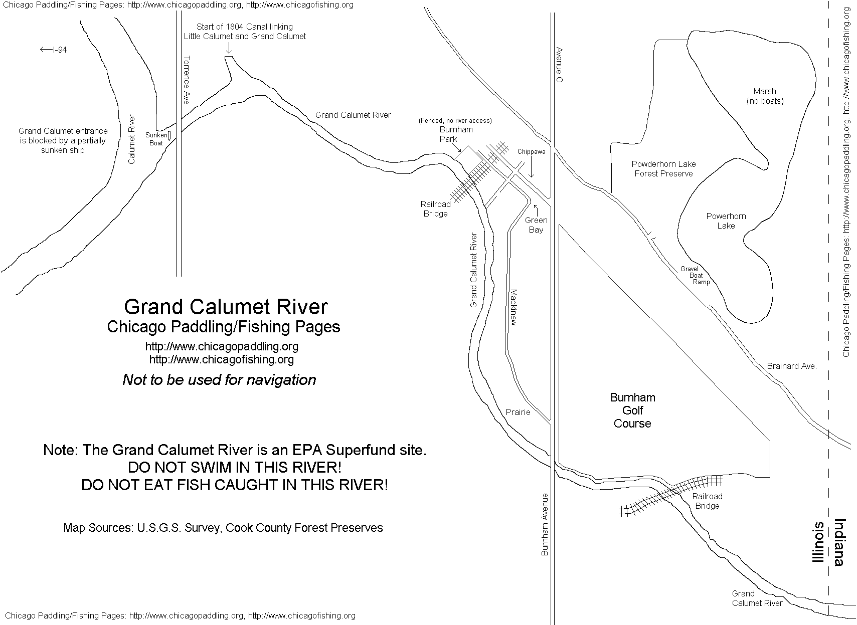
The Grand Calumet River is a U.S. EPA superfund site.
Its waters are badly polluted. You should not eat fish caught in that river.
You should not swim in this River. The river connects to several harbors in
Indiana and can at certain places have barge or large boat traffic. The water
flows from the Grand Calumet River into the Calumet River and into the Cal-Sag Channel.
I've searched a bit for access points and have not really found any clean, public
points to access this river from. There is a boat sunk across its mouth at the
Calumet River. Burnham Park is completely fenced in and the area near the rail bridge
has a gradual, wade thru the mud and muck sloping shore to the water.
An easy river to paddle both with and against the current, the
Little Calumet is a nice place to spend the afternoon. There is a lot of rail traffic
in the area (and near one bridge, you'll see two layers of train bridges, plus
an interstate highway high above them all. There are several very shallow
areas after heading west under the Ashland bridge (including one area that
is less than a half paddle blade deep... 4 - 8 inches at best...). Past the
heavy rail area, there is a strong odor in the air, but it's not from the
water, and if you paddle hard, you'll be past it in a few minutes. Under the
Halsted bridge, the water is shallow and you may have to carry your boat around
it.
Personally, this is one of my favorite rivers in Chicagoland to travel.
Give plenty of space between you and barge tows. Powerboats sometimes have a tendency
to travel thru the channel pretty quickly, so you'll if paddling, you'll want to stay
near the edges, but not so close that a wake will bounce you into the rip-rap. Due
to the water warnings regarding the Grand Calumet, I'm not certain that I'd fish here.
There are plenty of other places to fish in the area (Palos preserves).
There are two boat ramps that can accommodate trailered power boats:
- Calumet Boating Center (at Ashland and the river).
- Beaubian Boating Center (next to Altgeld Gardens Public housing).
Canoe/kayak access at: (carry-in dirt access)
- Calumet Woods
- Dixmoor Playfield
- Kickapoo Meadows
- Whistler Preserve
(On the barge channel, a bit dangerous, for the more adventurous boater)
Dams (Note: the Army will not let canoes/kayaks
in the lock, you'll have to portage)
![[grandcalumetsign]](grandcalumetsign.jpg)
Warning sign on the Grand Calumet
![[Grandcalumet]](grandcalumet200.jpg)
The Grand Calumet
![[A sundog]](sundog200.jpg)
A possible Sundog in the tree (Picture taken on the Cal-Sag Channel)
![[cal600a.jpg]](cal600a.jpg)
The Little Calumet from under the I-57 bridge, looking toward the Ashland Ave bridge
![[cal300.gif]](cal300.gif)
My son and a friend exploring a sunken ship on the Little Calumet River)
![[midlo150.jpg]](midlo150.jpg)
(Midlothian Creek meeting the Little Calumet River)
![[sign150.gif]](sign150.gif)
A humorous warning sign at the Calumet Boating Center
![[fireboat.jpg]](fireboat.jpg)
A old fireboat beached on the Cal-Sag.
![[calrail2.jpg]](calrail2.jpg)
A train resting on a rail bridge on the Little Calumet.
Calumet River and Cal-Sag Channel Charts may be accessed via
the U.S. Army Corps of Engineers Navigation Information Connection (NIC).
The Calumet Division of the Cook County Forest Preserve District has several facilities in the area.
[Caution: the Calumet Division map in the link above is none too accurate in showing the water features.
Not to be used for navigation!]
More River Access Maps will be online shortly
Grand Calumet River
Boating information:
- Private power boats, canoes, rowboats allowed.
- Outboard motors permitted.
- Boat ramps are concrete (both above and below waterline).
- Dams
Fish in the Rivers/Channel include:
Every year we take a family trip down the Des Plaines River for Labor Day.
This year, since there is a new rental company on the Des Plaines, we thought
we'd avoid crowds and try a river that we've been on before, but only in
certain areas. To say the least, the Little Calumet River/Cal-Sag is a bit
different than the Des Plaines. On the Des Plaines, you never really feel
like there is much around you that can take your life instantly. On the Little
Calumet, that safe feeling isn't there. You travel through peoples back
yards (people who aren't always happy to see you), through public parks,
with barges, speed boats and worse of all,
in a section that was only a foot deep, we traveled past a pack of wild
dogs (I did call the County today to report the dogs). Before starting the
trip, I knew that the Little Calumet was one of the worst rivers in the
state as far as pollution. I knew it before, and I still do.
The Little Calumet is a river of many sewer pipes. They run into the river
everywhere. The section of the river south of 130th street is to shallow
for powerboats and can only be explored by canoe or kayak. The section
north of 130th street, and east of Ashland is open to any boat and any size
engine. Once you pass into the Cal-Sag portion of the river, you also have
large barges to contend with. The Calumet waste treatment plant (which handles
all Chicago wastewater south of 87th street... a lot of water) is located at the
river bend.
Amazingly enough, there was a person waterskiing near the massive pipes that
dump the plants effluence into the river. (I didn't stay to watch, but I
hope he was really good and never fell in)
Some of the sewer pipes are not so bad and can provide great cool breezes,
(I would say that one we lingered by (it was 95+ degrees that day) was about 20 degrees
cooler than the air temperature) but others smell as if they are filled with...
well... nasty stuff. I called the county regarding the smell suggesting
that perhaps the dogs may be killing deer and dragging them near the tube,
hopefully they will investigate. The river water itself is an interesting
creamy/milky green color.
The Calumet and Cal-Sag have very little current, so little in fact that the
river was almost void of life due to no oxygen in the water. The government
stepped in and built aeration plants along the river, called SEPA facilities.
(Sidestream Elevated Pool Aeration) These plants
look great! They pump the water up and then drop it over a series of
waterfalls. This has provided much needed air into the water to support some
life in the water. At one time, even the Goby couldn't survive in the
Calumet, but now, the River/Canal that once barred the Goby from entering the
waterways of the interior of the nation is clean enough that the Goby can
survive. Now... where was I... Oh, so anyways, they take this really dirty
water and drop it down a waterfall, it looks really nice from all sides,
except the downwind side. The spray, the aroma, Oh My!
Our day was not without its good points. We helped a two men locate
their Remote Controlled Plane (named 'Yukon') that had crashed in the river.
Once the 'Yukon' was liberated, we continued our trip. In the non-navigable
section near Halsted and approximately 143rd street, we had to get out and
carry our boat across a shallow ford complete with cement blocks. I was
afraid to remove the blocks as I wasn't sure if it would end up draining the
east end of the river lower than it already was (we scraped bottom a lot).
While the river has a certain foreboding about it, I still like the Little
Calumet River. It has a certain personality to it. I'll travel it again.
![[Pre 1804 map]](cal1.gif)
![[Post 1804 map]](cal2.gif)
![[hullmap.gif]](hull.gif)
![[1893 Map]](cal1893.gif)
![[1897 Map]](calumetriver.gif)
![[Grandcalumet]](grandcalumet.jpg)
![[A sundog]](sundog.jpg)
![[cal600a.jpg]](cal600.jpg)
![[cal300.gif]](cal800.jpg)
![[midlo150.jpg]](midloath.jpg)
![[sign150.gif]](sign2.jpg)
![[calrail2.jpg]](calrail.jpg)