Illinois River
(State of Illinois, U.S.A.)
|
We are not responsible for errors or omissions.
When boating, regardless of water depth, wear a PFD!
|
It was spring, 1673, when Pierre Moreau, Jean Plattier, Jean Tiberge, Jacques
Largillier, and Louis Jolliet left Quebec City for the mission at St Ignace.
When they arrived at the mission, they met Father Dablon, the head of the
mission and presented him with a letter from Count Frontinac, the Governor.
The letter said the group was to explore the unknown country searching for
the great river the Indians referred to as Messip and to see if it offered a
route to Cathay, China. It was customary at the time to take a missionary
along on exploratory trips and so Father Dablon was asked to assign a missionary
to go with the group.
May 17th, 1673 they loaded 5 bags of corn meal,
2 strings of dried beef and a cache of trinkets to present as gifts to Indian
friends met along the way and left the mission at Michilimackinac (now simply referred to
as Mackinac). They arrived at St Francois-Xavier Mission on the shores of
Green Bay (referred to as "Baye de Puan" loosely translating to "that stinking place" due to its algae-rich green waters) on May 27th. They talked
with Father Allouez about what he had heard of the great river from the
Indians at 1657 at the great gathering on the shores of Lake Superior.
The Indians had told of a great river and warned the French not to go
there. They said great monsters that swallowed men and canoes whole lived in
it. They were also told that there was an alternative route to return to Lac
de Illinois (now called Lake Michigan).
Marquette joined the 5 men as well as a group of friendly Indians
(Mascoutens) who offered to show them the portage between the Fox (at the
base of Green Bay, Wisconsin) and the Wisconsin River to reach the great
river. After the portage had been made, the friendly Indians bid farewell
to the group and returned north, while the explorers made their way
downstream.
On June 17th, 1673 they met the great river and Marquette named it the
River of Immaculate Conception. As they traveled down the river both
Marquette and Jolliet kept journals. They encountered creatures they had
never seen before. Marquette tried to use his paddle to push away a log,
only to discover it was really a 10 foot long sturgeon fish that did not
take kindly to being prodded.
At one point they spotted a bluff with the face of a demon painted upon
it. Marquette wrote in disgust in his journal that such demon worship
existed here in the wilderness, but before Marquette could finish writing
his note the canoe encountered the swirling waters where the Missouri
met the Mississippi. The demon was simply a warning. This symbol remained
visible on the river until the 1850's, when the cliff was quarried for
gravel.
After they had reached the mouth of the Arkansas river they encountered
trade items of Spanish origins. As they were now already positive the river
was not a route to the far east, they decided to turn back. After days of
fighting the strong currents they met a group of Illinwek indians on the
west bank of the river who mentioned the other portage. On the trip downriver
the explorers had completely missed the mouth of the Illinois River. The
Illinwek gave the explorers a boy slave to show them the way, and so the
group continued upstream of the Mississippi until they reached the mouth
of the Illinois River. While paddling up the Illinois, they found the
village of Grand Kaskiaka. They spent several days in the large village
and Marquette promised to return as soon as possible.
They left with an escort of Illinwek indians to show them the Chicago
portage. After several days, Marquette wrote that the Illinwek women
had completed moving their gear across the portage and they were
ready to depart.
They paddled back to the mission, where Marquette and Jolliet made copies
of their journals.
Jolliet, Moreau, Plattier, Tiberge travel backed while Marquette remained
at the mission, however in running the LaChine rapids east of Detroit,
they swamped their canoe. Both Jolliet and Marquette's journals were both lost,
and one person drowned (it's debatable if it was Tiberge or a unnamed donne).
Jolliet gave Count Frontinac a verbal account of the journey as best he
could recall and drew maps (the original is in the Newberry Library in Chicago) based
on his recollection. He also informed Frontinac that the river appeared to
go to the Gulf of Mexico, and not the Pacific as hoped. Frontinac wrote
Father Dablon (then the head of the Jesuit missions in New France) demanding
the copies of the journal, which Dablon promised at the next spring.
Afterwards, times did not go well for either Marquette or Jolliet.
Marquette died before two winters passed, and Jolliet would be back
working at his fur trading post. At Quebec City in 1674, his sister-in-law
sued him seeking rent for her canoe he borrowed the year before.
More about Sieur de La Salle and Henri de Tonti can be found on the
Kankakee River page. Also check the Hennepin Canal page for part of their
parties misadventures.
Information sources for the above text:
- Discovery and Conquest of the Northwest, 1898, Rufus Blanchard
- Joliet, 1918, Carl Sandburg
- Early Chicagoland, 1928, Harley, Bradford, Mitchell
- The Illinois, 1940, James Gray
- The Heartland (Ohio, Indiana, Illinois), 1956, Walter Havigurst
- Marquette's Explorations, 1970 Raphael N Hamilton, S.J.
- Jacques Marquette, 1985, Joseph P. Donnelly, S.J.
Note: It's difficult to be certain about what happened because of
the canoe accident that Jolliet suffered. Historians agree that the text about
the trip is based on the Dablon Papers and not Marquette original journal (and
are especially suspicious of the dates because each is the 17th). I've
met one person who claims to have seen the monster warning painted on the
cliff, yet history tells us that the cliff was actually quarried away in the
1850's with quite a bit of fanfare and the image was still present at that
time but the entire cliff is gone now (similar to the problems of referencing
places in Will County when all the original references were made based on
Mt Jolliet, and now that it and 2 other similar sized hills have been
quarried, no one is quite sure where certain graves are).
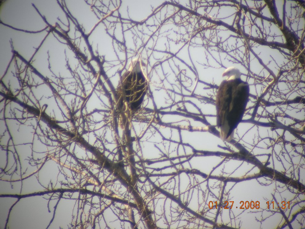
1/27/08 Bald Eagle Watch 2008; Went to view the Bald Eagles that
migrate to Starved Rock for about 4 weeks before returning north. There were
at least 10 Bald Eagles within view from the Illinois Waterway Visitors Center.
Check www.illinoisraptorcenter.org/eagle.html for more details.
A picture I took yesterday of two Bald Eagles (Nikon P5100 with external zoom)

The following text is from a Illinois Department of Conservation Booklet
The Illinois River and has been only slightly modified by us.
Despite man's continuing manipulation and pollution, the Illinois River
still provides a fine sport fishery. Recent surveys even indicate improvement
in sport fish populations is occurring. Sport species commonly occurring in
the river include largemouth bass, smallmouth bass, channel catfish, drum,
crappie species, bullhead species, bluegill and miscellaneous sunfish species.
With the large metropolitan areas of Chicago at its head and St Louis near
its mouth and by cutting more or less centrally through the northern half
of the state, the Illinois River is in an excellent position to provide
quality fishing to a great number of illinois citizens. Hopefully this guide
will help these fishermen make use of the abundant resource the river provides.
The Illinois River is formed at the junction of the Kankakee and Des Plaines rivers and runs 273 miles west southwest and south to enter the Mississippi 14 miles up stream of Alton. The river and adjoining backwaters provide an aquatic resource of some 87,000 surface acres. Besides the dam on the Mississippi at Alton in which pool the lower 80 miles of Illinois River is included, there are the LaGrange and Peoria dams on the lower 228 miles of sluggish river and the Starved Rock, Marseilles and Dresden Island dams on the upper 45 miles of faster flowing river. Diverse aquatic habitats are the basis for the diversity of sport fish present, as each species favors certain habitats over others.
Tailwater habitat, found below each navigation dam, is fast turbulent water caused by the passage of water through the dam. Tailwaters receive heavy fishing pressure because fish congregate in these rough waters. White bass are particularly fond of tailwaters, and channel catfish and drum are often caught there.
Lake and slough habitats have little or no current and may have aquatic vegetation. Lakes have greater average depths than sloughs. These areas are good for
bullheads and sunfish species.
Side channels are departures from the main channel and may be as wide and deep as the main channel or so shallow that they resemble sloughs. All side channels have current in them during normal water stages Channel and flathead catfish like side channels.
Main channel border habitat is the area between the edge of the navigation
channel and the closest land or shallow water over submerged land, This is the most predominant habitat along the Illinois and is so varied that most sport species can be found in some type of main channel border area.
Largemouth bass, crappie, and bluegill or green sunfish are so common in the Illinois that they are taken from all habitats.
Two crappie species occur -- the white crappie and the black crappie -- but, there is no apparent difference in their bait preference or methods used to catch them. Fish near stumps, brush piles or other such shelter. Small minnows are the most common bait and these should be hooked high in the back on a small hook with a bobber 2 to 3 feet above the hook.
Nightcrawlers can also be used effectively in early spring. When crappie start schooling before spawning (April and May) leadhead jigs and spinners become productive and may be used in combination with a lip-hooked minnow, Usually the best months are March, April and May; then fishing picks up again in the fall.
Sunfish occurring on the Illinois include bluegill, green sunfish, warmouth
and occasionally pumpkinseed or rock bass. Fish near cover such as brush piles,
stumps, or weed beds and drop your bait as close as possible to the cover. Use
as mall bobber to keep the bait off the bottom. The most popular bait is the
night crawler on a small hook, but crickets and grasshoppers work well during
summer. For ice fishing wax worms or corn borers are quite effective.
The white and yellow basses are the true basses native to Illinois.
Fishermen often call these fish "stripers", and this can cause confusion with
a larger salt water cousin (striped bass) which has adapted to fresh water
and has actually been taken from the Ohio River along Illinois. The white
bass is generally more abundant than the yellow bass on the Illinois River
except for localized areas in the Starved Rock pool. White bass grow larger
than yellow, making them more desirable sport fish, These fish like current
and turbulence as is shown by their abundance in tailwaters. They are taken
on jigs cast into the rough water below dams or obstructions in the main
channel border. Sometimes bass can be found in the quieter water along a sand
bar or bank in the main channel border. Spinners with minnows or artificial
lures resembling minnows are effective when a school of white bass are spotted
by the furious surface activity of minnows trying to elude them. Best fishing
seems to be in the morning or evening, but bass may be taken from deeper
water during the day by retrieving the artificial lure or minnow a short way
off the bottom. May and August have been the best months for bass.
Largemouth bass are taken most frequently in the main channel border and
lake habitats, They like the cover of weed beds, brush, stumps, willows and
fallen trees where they can hide from their prey. Since, largemouth are sight
feeders they are attracted by action and not by smell of the bait or lure.
They succumb to the temptations of a variety of lures, plugs, and jigs which
must each be retrieved in the manner best suited to the lure. Common lures are
Mepps spinners and plastic worms. Minnows hooked below spinners provide more
attraction than the lifeless form of a minnow alone, The best fishing is in
May, June and September; and once the weather warms to 75 degrees or better,
early morning or evenings are best.
Smallmouth bass populations are found in local areas above Peoria. Fish
weighing better than 2 1/2lbs have been collected by biologists sampling with
electrofishing gear. Although the smallmouth does not attain the size of
largemouth bass it is more of a scrapper and pound-for-pound provides more
heart-pounding action than any other stream species in Illinois. Artificial
lures such as plastic worms, jigs, spinners, and spoons are most effective,
but live frogs and crayfish are also successful. Fish in early morning or
late evening.
Walleye and sauger fishing on on the Illinois has improved considerably
the past few years. In the spring the tailwaters of Starved Rock Dam may be
crowded with boats of fishermen after their favorite sport and table fish.
Many of the fish taken are sauger, which may range in weight up to 5 pounds
(the state record sauger was 5 lbs. 12 1/2 oz. taken from the Mississippi).
The walleye are generally larger, and reports of 7-8 pounders come in each
year. A common lure is a jig-minnow combination with the minnow hooked
through the head and a weight attached via a three way swivel to fish the jig
a foot or so off the bottom. Lead head jigs or minnows by themselves are also
popular. The tailwaters can be fished through winter for walleye or sauger
because the rough water keeps them free of ice cover. Reportedly the largest
walleye are caught during winter and it takes the hardiest anglers to fish
for them.
Drum (sheepshead, white perch, silver perch) seem to prefer areas with good current such as tailwaters and the main channel border. Worms, shrimp, or minnows are fished on the bottom over bars, mud flats, or off a gradual bank in areas with moderate to strong current. Although partial to current many drum are taken fishing on the bottom of larger lakes. They can also be caught on trotlines using natural bait. Spring and fall are the best seasons for drum.
Catfish are the meat fish for many people who appreciate the occasional 10-15 pound channel or 20-30 pound flathead they catch along with the common 2-10 pounders. "Cats" like to hole up underneath old stumps, downstream of fallen trees, around log jams, and in washout holes along banks. Since these fish rely
primarily on their olfactory sense to detect food, prepared baits with a strong odor are most effective. These include blood baits, cheese baits, and various homemade concoctions of an odor so rank that the fisherman can hardly handle them. Worms, liver, shrimp and an almost end less variety of goodies are successful
at one time or another for catfish. The more solid prepared baits can be balled around a treble hook and fished on the bottom with a tight line weighted by a sliding sinker, Pieces of sponge rubber are dipped in baits having a thinner consistency and placed on or before a hook, Around trees and log jams a bobber may be necessary to prevent loss of gear. Many catfish are taken on trotlines baited with crayfish or fish, If you're seeking flatheads use large hooks and big bait such as 6" carp on your trotline, Fishing picks up for catfish when it is slacking off for many species during the hot months of summer (July through September), Since sight (hence light) is not necessary for feeding catfish, some of the best fishing may be throughout the night.
Black, yellow and occasionally brown bullheads are found in the sloughs. Nightcrawlers are the most common bait, fished beneath a bobber or on the bottom without a bobber. Shrimp, grasshoppers, grubs, liver and prepared baits are among things considered desirable by bullheads,
As with their larger cousins bullheads will feed all night, tempting many fishermen to stay out until the wee hours of morning during the warm summer months.
This discussion would not be complete without mentioning carp. Carp are not considered in the maps section, because they are so common that they can be caught almost anywhere. Their size and fighting strength are increasing the carps popularity every year. Next to the flathead catfish, carp are the largest
fish regularly taken by anglers on the Illinois. Properly prepared, carp are a
match for any fish in palatability. So it is no wonder that more and more
fishermen are actively seeking carp with worms, corn and doughballs among
other baits. Doughballs can be made from flour, water, and a flaky breakfast
cereal, which mixture is formed around a treble hook. Fish on the bottom or
near the bottom with a bobber in shallow areas from May through October.
In the maps section some of the access areas available to the public are
noted. Certain public areas and private areas open to the public are available only after paying a fee and such fees are usually posted. Unless an area is known to be public or is posted as a public area, it should be assumed that it is private and permission from the owner is necessary to use that area.
On the maps areas have been marked that are known to have good sport fish populations. Each area is marked showing the sport fish most likely to be taken there. It is realized that the areas marked represent only a portion of those occurring on the river, and as more fishing spots are discovered this guide will be updated. Access sites available to the public are labeled and list the basic facilities found at each site. NO attempt was made to list all access sites, but only those nearest fishing areas marked on the map.
Boat ramps that can accommodate trailered power boats:
- W.G. Stratton State Park
- Illini State Park
- Allen Park
- Starved Rock
- Peru
- Spring Valley
- DePue
- Hennepin
- Henry
- Lacon
- Chillicothe
- Woodford
- Detweiler Park
- Peoria Dam
- Bartonville
- Pekin
- Kingston Lodge
- Springlake
- Liverpool
- Havana/Spoon River
- Bath
- Anderson Lake
- Beardstown
- LaGrange Lock & Dam
- Meredosia Lake
- Meredosia
- Naples
- Florence
- Pearl
- Godar-Diamond
- Glades
- Hadly Lodge
- Long Lake
- Pere Marquette
- Swan Lake
- Polhman Slough
- Grafton
Boating information:
- Private power boats, canoes, rowboats allowed.
- Rentals available at Starved Rock
- Outboard motors permitted.
- Boat ramps are concrete (both above and below waterline).
- Locks and Dams
The Rock, or Le Rocher (As de la Salle and de Tonti referred to the area
we now call Starved Rock). Henri
de Tonti fought two battles against the Iroquis from this position. The
first, in 1682 was a failure and he was badly wounded, the second, in 1684
was a victory and is generally considered the beginning of the end of the
Iroquis raids.
| U.S. Army Corps of Engineers River Navigation Maps
|
New 1998 navigation maps are available at the U.S. Army Corps of Engineers
Navigation Information Connection web site at
http://www2.mvr.usace.army.mil/NIC2/ilwwcharts.cfm
| River Access and Fishing Maps
|
![[River Map]](il230270tn.gif)
Illinois River between Utica and Dresden Dam (River miles 230 thru 273)
![[River Map]](il190230tn.gif)
Illinois River between Lacon and Utica (River miles 190 thru 230)
![[River Map]](il150190tn.gif)
Illinois River between Pekin and Lacon (River miles 150 thru 190)
![[River Map]](il110150tn.gif)
Illinois River between Anderson Lake and Pekin (River miles 110 thru 150)
![[River Map]](il80110tn.gif)
Illinois River between LaGrange and Anderson Lake (River miles 80 thru 110)
![[River Map]](il4080tn.gif)
Illinois River between Pearl and LaGrange (River miles 40 thru 80)
![[River Map]](il0040tn.gif)
Illinois River between Grafton and Pearl (River miles 0 thru 40)
Fish in this river include:
Coming soon...
Sewage Discharge into the Illinois (Based on 7 year, 0 day low reports from Illinois EPA)
Upper Illinois Water Quality Information (Illinois EPA)
Middle Illinois Water Quality Information (Illinois EPA)
Lower Illinois Water Quality Information (Illinois EPA)
![[Starved Rock]](starvedrock.jpg)
![[River Map]](illinois230-270.gif)
![[River Map]](illinois190-230.gif)
![[River Map]](illinois150-190.gif)
![[River Map]](illinois110-150.gif)
![[River Map]](illinois80-110.gif)
![[River Map]](illinois40-80.gif)
![[River Map]](illinois0-40.gif)