
| Main Page | Diary | Leaves | Stats |

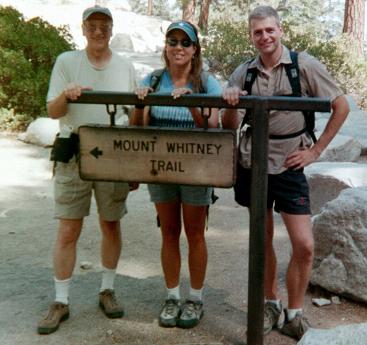
283. Mt. Whitney Trail (09/12/02)
Hikers (3): Cal, Janice, Steve
Distance: 22 miles
Rating: 6 difficulty, 10 beauty
Park info: Inyo National Forest near Lone Pine, CA
Write-up by Cal -- Pictures by Janice, Cal and Steve
This was the first (and maybe last) INCH hike to Mt. Whitney, the highest mountain in the contiguous United States standing (14, 496 ft). Normally, this 22-mile-round trip with 6,000 ft elevation gain is a two-day hike, but we could only get one-day permits. So a day hike it had to be. Due to the late time in the year (and nature of the hike), only Steve, Janice, and Cal had the time (and energy) to make the trip.
PreparationSeveral weeks before the hike, we all researched Mt. Whitney, and interviewed anyone we could find who had hiked it. Several things were clear: (1) we needed to start the hike early in the morning (before dawn), (2) altitude sickness could be a real problem, particularly for a day hike (3) the park was very picky that permits be arranged ahead of time, and (4) 22 miles of hiking at 8,000 - 14,500 feet would not be a piece of cake. We all got Dimox prescriptions to prevent altitude sickness, although we continued to debate if it was needed and what the proper dosage was (Steve took half doses). We prepared lists of what we would bring in order to prevent duplication: tents, sleeping bags, tarps, a stove, food, extra cloths, head lamps/flashlights, two water purification units, and our standard hiking gear. We were ready to go.
Leaving for Whitney (September 10th)
I picked up Janice and Steve about 5pm on Tuesday night and we headed off. Stopped at the famous 'House of Beef' in Oakdale but it was closed. We vowed to return! Found a restaurant down the street and fed our faces. Continued the drive through Yosemite (including gas at $2.70/gal) and continued over Tioga Pass. Steve was disappointed that they did not request an entry fee at night when we went through since he had his National Park Pass. By this time Janice, who was in the back seat, had hit the hay; occasionally waking up long enough to mumble a few words like "are we there yet" to which we would reply "almost".
We rolled into the campgrounds at about 1:00a. The site was great (even in the dark) and was capable of handling 6 tents or more. So we all got choice spaces within earshot of the "babbling" brook along side our campsite, while taking advantage of the space to separate from each other lest anyone start snoring loudly. The setup of the tents went well and we were all in bed about 1:30a.
The Acclimation Day (September 11th)
The plan was to spend one day at altitude before the hike to allow our blood to adjust and help with the altitude sickness potential. We headed toward the Whitney Portal store via a trail from our campsite. We were warned on the path up the trail that the store was closed, and when we got it was--in remembrance of September 11th. This had two consequences: (1) no breakfast and (2) no showers. So the next thing to do was go down to Lone Pine for our day-hiking permits (which we had dutifully reserved the week before). We signed papers about crapping on the trail, got breakfast, and headed off to check out the local stores. We noticed a local barber shop also doubled as a public shower and decided that before the day ended we would have to return and use them since the campsite didn't have any.
We headed back to our campsite and got ready for a practice hike. Since we would be starting the hike at night, we wanted to find the trailhead and travel the trail to get a sense of its composition. We hiked for about 1 hour and realized that if we wanted a shower, we better get back to the barbershop, and did just that.
Well "Kirk's Public Showers" were something to behold. We had to get the key from the hardware store a few stores down because our good friend Kirk was out to the doctor's office. We entered the "public shower" door in the back of the building and were greeted with a small area crammed with 3 not-so-clean-looking showers (luckily one was segregated by a door for Janice). How low can you go!? But they supplied clean towels and the water was hot. Feeling good after the shower, we headed to a pizza place for dinner (where, as it happened, they actually mistook "Cal" for "Calzone", but that's another story). With our bellies full, we headed back to camp and into bed by 7:30p.
Time to do the Hike
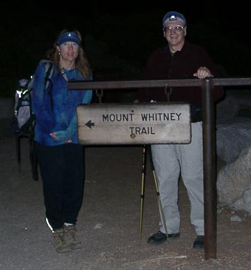
My alarm went off at 2am. Steve was also up about the same time and Janice shortly after. We got our packs ready, handed out the walkie-talkies, and did the short drive to the trailhead where there was a reasonable amount of activity. We were not the only ones leaving at this time (about 2:30a). If fact, considering the time, it was downright crowded.
Janice and I had headlamps and Steve had a crappy little flashlight, which resulted in him being captured between Janice and myself in order to see the trail. Up the trail we went, through the first set of switchbacks, over a stream via logs (where I lost my balance and almost fell in). Onward past Mirror Lake the trail started to change from dirt hiking to more of a rock makeup. We would go over large rock formations where it was difficult to follow the trail in the dark. As we hiked, we came upon other hiking groups trudging up the switchbacks. We would hike behind them because they were setting a good pace but in all cases, the group would stop and request we pass. Since we had showered the night before it must have been our pleasant personalities they didn't like. Strange phenomena.
Cal is not sure he can make it
After about 2 1/2 hours of hiking, we started up some serious rock trails. It may have been the pace (which wasn't very fast) or just the altitude but I felt like my legs were not going to make the hike. I said to Janice and Steve they should go ahead and I would continue at a slower pace. Since it was just getting light, Steve didn't really need his flashlight so was off like a flash. Janice, who had a bad headache, said she would stay with me and we would go at a slower pace. My legs eventually recovered.
It Was Cold
We continued to hike past trail camp and towards base camp. Over rocks, rocks, and more rocks, but kept a steady pace. I had taken everything except gloves--a big mistake. My hands were freezing, but Janice came to the rescue. She had an extra pair, which I readily accepted. My hands were so cold that my fingers wouldn't work to take the Walkie-talkies out of my pocket. Steve would keep posting us on his progress and was clearly hours ahead of us. We reached base camp where numerous tests were set up and the hikers were starting to rise. We talked to them about the trail to the summit and how long it would take. Janice pumped water because my hands were still so cold that I couldn't work the pump.
Up the Major Switchbacks
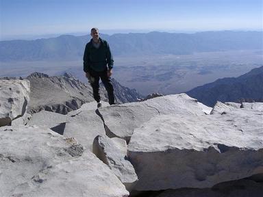
Leaving base camp (Trail Camp), you start the climb from 12,000 feet to 14,000 feet via a major set of switchbacks (approx 100). As we trudged up the switchbacks it started to get warmer because the sun was heating the trail--at last my hands could move. Janice kept feeding her headache with pills, gutting it out like a trooper. After several hours of hiking we reached the crest. Steve had already summitted by then, about 3 hours ahead of us. We continued on the trail, which goes on the back side of the mountain range. The valley on the other side is very pretty with various lakes - one shaped like a guitar aptly called "Guitar Lake". The trail is now a series of BIG rocks. You are no longer hiking but rock hopping.
The "Windows"
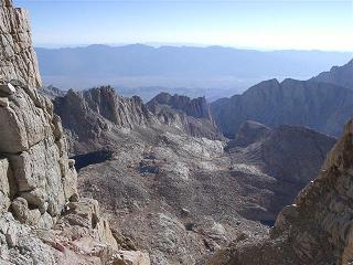
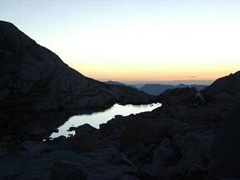
During the trip preparation and in discussions with the Rangers, the subject of the "windows" was mentioned. There are supposedly two areas of the trail that are extremely narrow with steep fall offs on both sides. One write-up talks about people crossing the windows on their rear end. As we approached the area where they existed, we asked a seasoned hiker† where they were and he said we had passed the first one already. The second one was a joke. So we had worried about the windows for nothing--they were at least six feet wide if not more. [† That "seasoned hiker" was me {Steve}, who passed these guys on my way back down the mountain. We had a long discussion right beyond the window, where I assured a disbelieving Cal that he most certainly had just passed the first window. Apparently diamox does not protect from all high altitude effects! The picture to the right is the view from the first window]
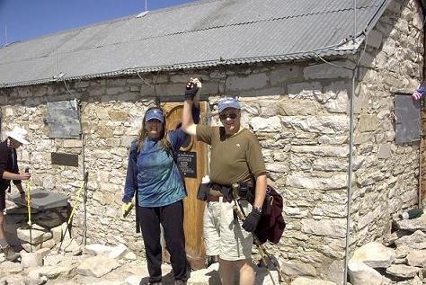
The Summit
After longer than I would had hoped, we reached the final trail to the summit. In the process, we passed Steve on his way down. The altitude made us go slowly but there was no gasping for air like we expected. We finally saw the Smithsonian rock house on the top and knew we reached our goal. Janice sat down against the house wall, gave a "V" for victory sign along with a big grin. We had made it by noon. After taking a number of pictures (including one of Eugene), we signed the register and started back down.
Heading back down
The only major issue on the way back down is the fact you have to climb 500 ft up along the way. This really affects your morale and was the toughest point for Janice. We reached the crest and it was all downhill, more downhill, and more downhill. The sun started to get low in the sky and we were hoping to make it back before dark. Steve was already back at the trailhead, showered, and trying to sleep in the car. I would call him ever so often so he wouldn't get too comfortable.
We emerged from the trail at about 6:45p (16 hours of hiking which, according to the Ranger, is the average for a one day assent; Steve took about 12.5 [Steve: According to my camera picture times, it took about 6h 45m to get from the trailhead to the USGS marker at the peak, 45 minutes of tooling around/geocaching, and about 5h to get back down]).
Camp, Food, and Bed
We were all tired so we fixed the quick camp food that you can just boil water, pour it in the pouch, stir, and eat. Janice and I would have loved a shower but everything was so close there was no way we were going anywhere but bed. Into our tents before 8pm and off to dreamland.
The day after
We were all up about 8am and packed up. I thought I would be stiff but we all felt good. We headed to Lone Pine for breakfast and off to Mammoth to visit Devils Postpile but that's yet another story. We started back to San Jose about 2-3p and arrived back about 9pm. On the way, we did make it to the "House of Beef" and had a great supper. We all said that one hike up Whitney is enough, but painful memories fade quickly and who knows. . .we may just do it again someday.
Many years later ... Peter and David made a (non-INCH) trip to Whitney. Here's the writeup.
Milestones:
Highest point in Inyo/Tulare county
![]()
![]()
Pages maintained by Steve Walstra,
Peter Saviz, and
Russell Gee.
©2026 Intrepid Northern California Hikers