
| Main Page | Diary | Leaves | Stats |

390. Humphreys Peak (05/01/04)
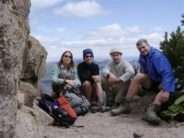
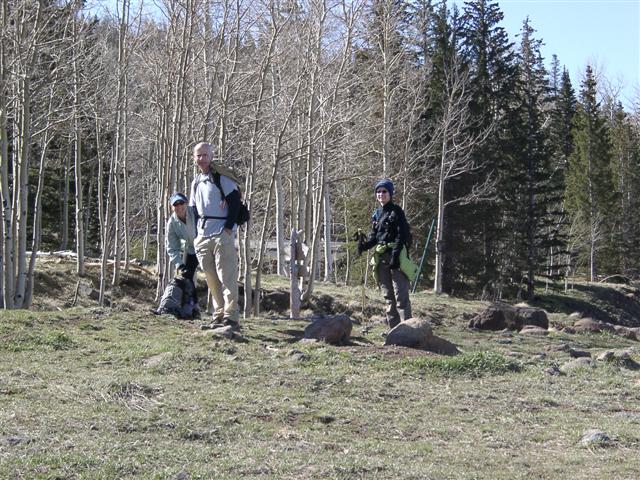
Hikers (4): Janice, Padraig, Steve, Tania
Distance: 9 miles
Rating: 5 difficulty, 10 beauty
Park info: Coconino National Forest in Arizona
Write-up by Steve and Tania -- Pictures by Steve
From Steve:
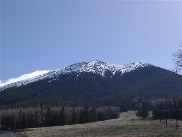
Humphreys Peak is highest peak of San Francisco Mountain, a huge volcano that blew its top a few thousand years ago. At 12,633 ft, Humphreys is also the tallest peak in Arizona, which is excuse enough to hike it. It's normally hiked in summer, but since I was going to be in Phoenix for a conference, May 1st seemed close enough.
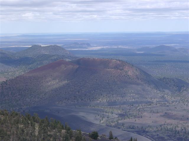
The day before the big hike, we visited Sunset Crater National Monument, where we hiked O'Leary Peak. O'Leary is the 20th highest peak in Arizona, and we had it all to ourselves. Perhaps Humphreys would be like that tomorrow?
From the top, we had a great view of Sunset Crater. There were half a dozen other cinder cones visible in the distance. O'Leary itself is a dormant volcano. The place is a happening hot spot.
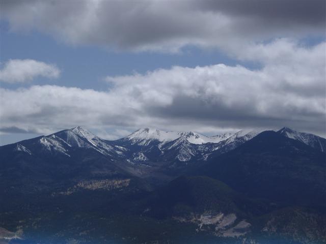
We could also see that more snow was likely falling on tomorrow's goal. . .
At 7 am the next morning, we were fighting the retirees for the fine continental breakfast at the hotel. After a nice drive up toward the skierless Arizona Snow Bowl, we got much closer to our goal--and it looked rather daunting. We were on the trail at 8:45 am.
1, 2, 3 . . . INCH!
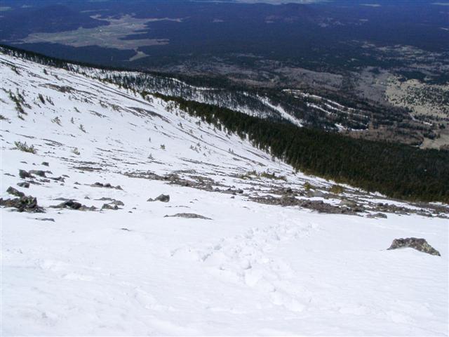
We knew there would be snow, and had heard it could be very windy at the top, so everyone was prepared. A guy we talked to at a gear store the day before suggested we could posthole up to our knees in places. This turned out to be true--gaiters finally paid off.
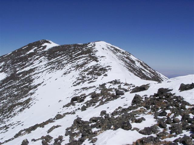
Three hours later, Padraig and I were at the saddle along the ridge line. This was no small feat, as there was no trail after about a mile and a half. From there, we just made our own trail up toward the saddle. Padraig left arrows every time we crossed paths with another half-ass trail. Once we were out of the tree line, the destination was clear. Between the ice, snow, and loose volcanic rock underneath the snow, the final charge to the ridge wasn't easy. Then again, it probably wasn't any harder than in the summer, when one would have to hike on loose rock the whole way up.
According to the radio, Janice and Tania were following along nicely. By the time we rested at the ridge, they were supposedly just getting out of the tree line below us. Padraig kept declaring that he could see them, but then recant. Since we'd be out of radio range over the first peak, he decided to wait a bit to see The Chief for sure.
I set off for the peak, which the GPS said it was about a half mile away. After going around the first false peak, the real peak was finally visible.
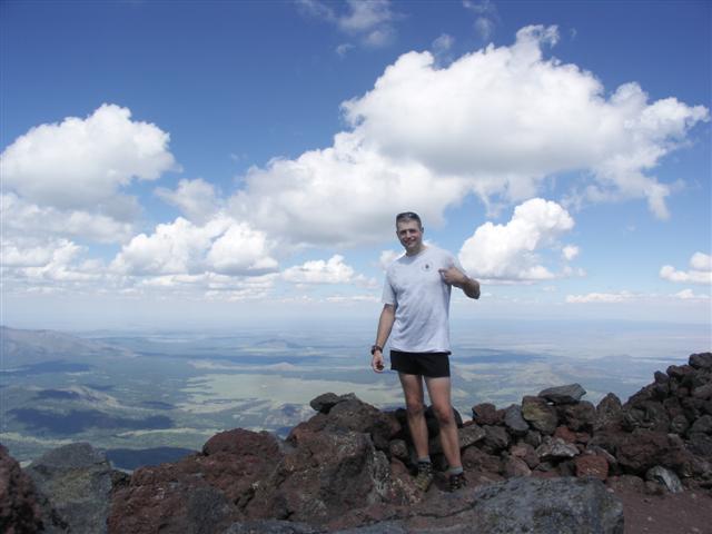
Arrived at the top at 12:15 pm, where I discovered the painful truth that the Humphreys sign was gone! This left me posing with the remaining post. . .

After waiting 45 minutes (and chatting with three other groups who made their way up at different times), it was clear something was wrong. After hiking back to the ridge, what do I find? Well, not Padraig or anyone else. The only logical conclusion was that someone was injured/sick, so they had all turned back. I high-tailed it down a steep route, making yet another new trail to confuse future hikers. This was actually the best way to go, as it was much easier to plunge-step straight down than try to follow a trail. After intersecting with the main trail, I reached the sign-in register we had logged near the beginning of the hike. Surprisingly, none of the other three had written a comment on the way out, leading me to believe that maybe I had passed them on the way down. When I reached the parking lot around 3:00 pm, it was confirmed: they weren't waiting impatiently for me--they were still on the mountain!
What could have happened to them? After finding the ski lodge closed, I was forced to leave them on the mountain in order to answer a different call of nature. This turned out to be torture, as I found myself driving behind Padraig's distant speed-limit-following cousin the entire way down the mountain. During that span, the fuel light reminded me that I'd also have to get gas in order to return to the trailhead. When a gas station was finally found, there was actually a line outside waiting for the restroom--the Gods were conspiring against me! Long story short, all the issues were resolved, but it was a full 50 minutes until I got back to the trailhead. . .and they still weren't there!
From Tania
The ambiguity of a snow-covered trail eventually led to a critical turning point for Janice's and my experience of the hike. Somewhere along the way, we ended up following another set of prints which we thought belonged to [Steve and Padraig]. Once breaking a few hundred feet of elevation, the trail had given way to patchy areas of snow and ice, which finally gave way to constant snow underfoot. This we expected. What we didn't expect, but found out later, was that the trail of the day was no trail at all after a certain point, and everyone on the mountain that day somehow made their own way up by breaking trail. We thought we had been following a one and only trail up to the summit; the footprints assumed made in part by the guys.
Janice and I continued along the icy trail, which cut into the side of the mountain and fell away to our right in a respectably steep slope. Hiking about ten feet in front of me, Janice suddenly slipped and fell, and somehow ended up prone on her stomach, her legs pointed down the slope. I asked her if she was alright, and she said "yes", but with every movement and attempt at righting herself, slid farther down the slope. I could see as I neared her position that sliding down was not a preferable option; the nearest tree that would break her fall was a good fifteen feet below. There were a few boulders that jutted from the trail, so I sat on the ice and braced my feet on them. I extended one of my hiking poles, held the handled end to her, and she grabbed it. Immediately, the pole extended almost to its full length, the sudden extension sliding her back another half foot down the slope and pulling me forward, which brought on some hasty grappling on my end of the pole in order to keep a firm grip. Everything now depended on the integrity of the pole; luckily, it ceased to extend past its maximum stopping point.
Both of us now fully on point, Janice took note of a boulder a few feet away from her left foot and managed to slide over to it, step onto it, and boost herself up to grab the next set of boulders that were a few feet below my position. With one hand on the pole, she grasped a boulder and quickly clambered up. Safely back on the trail, we rested a bit and managed to laugh nervously over what had happened. It was a solid couple of minutes before we gathered ourselves and carried on down the trail again.
Before long, to our right we caught our first glimpses of the mountain we thought was Humphreys, and came upon a wooden marker in the snow which read, "11,400 Feet" and something about a $500 fine for going off-trail. Seeing neither trail police (nor trail, for that matter), we surveyed the immediate area to glean guidance from the tracks that had lead us there. To the left of the marker, the mountain opened up to a steep incline which ended at a ridge edge. To our right was steeper downhill slope, and ahead was rather sketchy in terms of old footprints which had clearly been set days before, and nothing fresh but for the few tracks which led straight up the steep face to our left. Janice radioed in to Padraig that we had reached the marker, and she asked where he and Steve were. The reception was poor, but the two of them managed to communicate that the guys had never happened upon any such marker. We thought we might be off course at that point, but couldn't see how. We had been following absolute footprints the entire way. But if not the guys' footprints, whose?
From the marker, we spied two sets of prints which diverged briefly from one another but eventually met before diverging again about twenty feet up the left face. The set to our right appeared to be boot prints; the set to the left were made by an individual with crampons. Though both sets led up the steep face, we opted for the left prints since they seemed to hug a sparse tree line of Bristlecone. Steve had told me that the conditions of Humphreys were comparable to those of the Adirondacks in that the tall, stately pines give way eventually to the more durable, squat Bristlecone that dot the steeps and withstand forceful gales. We shoved off, believing that at least, we would be paralleling the guys' tracks.
Maybe twenty feet into stabbing our way up the face, we suddenly realized that indeed, this was rather steep and turning back didn't seem a grand idea. We were still wondering where on the trail we were supposed to be post-holing up to our knees; the snow here was maybe a foot or so deep, but slicked over with a layer of ice. All just superficial frosting for what really lay beneath.
It was clear after a few more yards that we could save energy by tag teaming up the face. One of us would go ahead and make steps, and the other would follow, then we’d switch. We made goals for ourselves; get to that tree up on the left, get to that patch of rock on the right, etc. I started out by leashing my poles and clawing the ice with my non-waterproof gloves while kicking small foot holes with my non-cramponed trail running shoes (did I mention we were unprepared for these technicalities?). Janice had small, four-prong crampons but they kept sliding up and around her instep and didn't lend much to giving her purchase on something requiring toeholds. So we were basically doing a crawling freeclimb up the face, trying very hard not to look behind us at the mountain falling away at a dizzying angle. One false move and we'd be skidding down the ice and heading for the unforgiving trees.
Making our goals of the first two trees, the altitude was beginning to dig its heels in and start a headache going for Janice. I was okay in that regard, but could feel the heightened intensity of what should've been the equivalent of a leisurely indoor rock climb. I was dragging. We decided to make our next goal a snow-free patch of lava rocks. We climbed on.
I immediately learned a swift and powerful lesson about lava rocks. The second Janice and I would think we'd have a grip, we’d slide back about half a foot. Up a foot, back a half. With each push feeling our hearts in our throats and trying desperately to get any kind of hand or foothold. Janice noticed some scraggly, dormant rosebushes growing intermittently in patches amongst the rocks and yelled over to me to aim for those to grab onto. I thought, "is she crazy!?" Knowing what I was thinking, she added, "They'll have strong roots. They have to, in order to grow up here! Grab onto them!" She was absolutely right. Crawling through these low-growing scraggly buggers wasn't pleasant, but they held. In some cases, a bit too well, as the barbs managed to bite through my fleece gloves and cling onto my skin. Ow!
We continued this crawl up/slide back dance up the face, eventually making our way to more Bristlecone clusters, which we utilized to hoist ourselves up for much-needed rest breaks. Knowing we were atop a precariously sloped lava scree field, covered with by an indeterminate depth of snow kissed by a glazing of sheet ice didn't encourage many confident thoughts. Each stab with our feet and punch with our fists would send snowballs in jellyroll formation flying down the slope. I wondered about the layers of snow and ice beneath us, and how many snowfalls and thaws and rains and more snowfalls were involved. Thoughts of shear strength entered my mind. Since Janice had never snow-hiked before, I figured she might not know what those things meant; I decided to keep that bit of info to myself for the time being.
Finally, the ever-present ridgeline suddenly seemed attainable. We pushed the last dozen or so meters up and finally came upon the saddle, and for the first time since we began our ascent, stood upright. The wooden post indicated some trail to our right, and something else to our left, but we weren't in the business of paying much attention other than that we had 'made it'. Though not at the peak, we were sure we were at the saddle on which the guys were waiting for us. Or so we thought.
Janice radioed Padraig again, and our spirits fell when he radioed back that we were not in his sights. He was on the saddle but so were we? Janice began to describe our vantage point; the mountain to our immediate right with a ski lift on it, the sign for a trail leading to it, an outcropping of huge boulders to our left. . .
And that was the key. Padraig was on the saddle all right, but on the other side of the rock outcropping. Neither party could see the other, but he urgently insisted that we must climb or traverse around the outcropping to get to the Humphreys saddle on which he stood. No one stopped to consider where or how we ended up where we were, and we re-shouldered our packs and started picking our way around the outcrop.
About halfway through picking around and climbing and post holing and sliding, I lost it. We were mid-traverse around the outcrop, and I somehow couldn't seem to advance. At that point, Janice radioed Padraig and he came down to get us. We rested there for a bit, and Janice took the opportunity to wring out her soaked socks as we warmed up a bit in the sun. Padraig reassured us that we'd make it down the mountain just fine, but we just needed to make the extra push to get up onto the correct saddle. After a few more minutes of resting, we set off. Padraig and Janice both helped me get my mind off the mountain falling away to my left, and we finally parked on the saddle.
It was there that we learned that Steve had made the push for the summit on his own. Janice's headache was getting increasingly worse, and our nerves were shot, so we decided without any hesitation that we were done. The summit could welcome us back some other day. Padraig formulated a game plan at that point; Janice and I would stay put at the saddle (thank goodness we were blessed with perfect, sunny weather; barely breezy and not too cold at all) while he hiked to the summit to collect Steve. He figured Steve wouldn't leave the summit without us, and at best, even if he started back, Padraig would run into him on the trail back to the saddle. So Padraig set off.
For the next hour, Janice and I sat on the edge of the saddle and had a bird's eye view of the face that the guys had come up. Many other people were coming up (and down) that route, and though still quite steep, it was more palatable than the scree field of death we had just endured. We chatted with everyone who passed by, and learned that there was no actual trail up to the saddle, and everyone just sort of broke trail at some point and came straight up. The route before us was definitely the more traveled; we came up a doable face, but knew it could've been far less terrifying had we the correct gear for it.
Before long, we received a signal from Padraig. Janice went on the radio, and Padraig's voice over the airwaves came back flat and heavy: "He's gone. I'm coming back."
We didn't know what to make of it. Was there another way off the mountain? A better way that Steve had discovered from the summit? We hadn't seen him on the way to the saddle where we sat, and so could only assume one of two things: that he had found a way from the summit, or he had long since descended before we even got to the saddle. The problem was that Steve didn't have a radio, and so we had no way of finding answers. I decided to call him on my cell phone. His phone was off, but I still left a message. Padraig was in sight, so I indicated that we were shortly about to make our way down the mountain.
A few steps into our descent, it was clear that my usual fear of downhill hiking, as real as it is irrational, was monumentally worse due to the previous events of the morning having taken their toll on my nerves. I was reduced to a quivering mass of useless flesh that required literal handholding and step making on Padraig's part. Janice was behind me, and she tried to ease my mind off the steeps by talking about wood burning art and peanut butter pretzels (aptly renamed "penis scrabble" by Padraig; must be an Irish thing). Padraig continued to lead our ragged expedition down the mountain, patiently reassuring me while watching out for both of us and choosing more forgiving gradients to blaze trail through. Janice's headache worsened in intensity, but she kept me together with as much conviction and compassion as did Padraig.
After quite a bit of stepping, falling, sliding, tripping, more stepping, resting, etc., I felt confident enough to just follow Padraig's tracks and utilize my hiking poles for balance. That worked out pretty well, but by then, Janice's headache had taken over and managed to combine with her own frayed nerves from earlier. Padraig eventually had Janice and I switch places, and I gave her one of my poles. We continued to post hole, slide and trip our way down. Padraig's plan was to just get down off the mountain; at some point we would hit the trail, which switched back and forth across the mountain through the trees. Without maps or GPS, his plan to just head straight down was sound.
Janice and I were quite frayed mentally, and at least once challenged the route we were taking. At one point, Janice spotted a descending hiker a couple hundred yards down and right of us; we had observed him earlier in the day coming up the Humphreys saddle. She yelled down to him, "Are you on trail!?" but he didn't hear. Padraig turned around and said, "Chief, no one's on trail. There IS no trail. If you want to follow that guy, go right ahead!" Our disposition was pretty raw, but Padraig's commanding volume left no room for questions. We pushed on.
A little while later, Janice spotted some cut logs ahead of us and indicated there wouldn’t be cut logs unless there was a trail nearby. She was right. No more than five feet from the cut logs, our feet hit solid, snow-free ground. It wouldn't last, however, as there were still intermittent patches of snow and ice to be had, as we were still pretty far up the mountain but at least we had a discernible trail underfoot. About half an hour into trudging along and skidding a bit here and there on icy patches, I stopped dead in my tracks, absolutely convinced we were going the wrong way. I voiced my concern, and Padraig turned around, wide-eyed but calm. "Tania. We've been going downhill the entire time since we hit the trail. Think about it." I was convinced somehow that we had been on this very same stretch when we started out early in the morning, and going in the same direction as we were at that time. I decided to suspend my delirium and just trust Padraig; we had come this far already. What he was saying didn't sink in until later, and I had an epiphany of sorts as we continued down the trail: "Oh yeah! You're right! We have been going downhill!" Amazing, how stress can distort one's common sense and logic.
After what seemed an eternity, we ran into our first sign of civilization: an older couple and their son out for a walk with their small dog. Of course we stopped and chatted with them, and I couldn’t help but notice that the little dog they had looked exactly like my dog from years past. I won't get into the blubbery stuff that transpired at that point and whatnot; just chalk that off to more stress.
We eventually came upon the sign-in post, and saw that Steve had indeed signed out. He didn't write in a time, so we didn't know how long he'd been waiting. It was still an appreciable distance to the parking lot, but we managed the home stretch with ease. Of course, upon getting back to the cars, the floodgates of mountain psychosis burst and the stress of the day unleashed itself with renewed vigor. I couldn't help but think, crap, this isn't anything near what Joe Simpson went through, but for us, it was bad enough.
In retrospect, one can analyze how things went the way they did for Janice and me that day. For me, personally, gear is an important issue. We could've used full-scale crampons and had a backup safety rope in our possession. We should've all been equipped with radios, no doubt about it. Accidents can happen anytime to anyone, but there are easy measures of precaution that can be employed to improve everyone's chances of meeting their objective—first and foremost, having a safe, fun time. Padraig's notable leadership abilities reminded me that we could all use a bit of emergency training. And in the end, without a doubt, we could all use a bit of penis scrabble. :)
Milestones:
Highest point in Coconino, AZ county
![]()
![]()
Pages maintained by Steve Walstra,
Peter Saviz, and
Russell Gee.
©2026 Intrepid Northern California Hikers