
| Main Page | Diary | Leaves | Stats |

449. Mt. Tamalpais (06/11/05)
Hikers (22): Bruce, Carissa, Davey, David, Dinesh, Edita, Eugene, George, Gwynneth, JP, Oliver, Ondine, Paul, Ramesh, Randy, Rich, Rick, Steve, Steve Wi, Walter, Wennie, Yipeng
Distance: 10 miles
Rating: 3 difficulty, 10 beauty
Park info: Marin Municipal Water District near Mill Valley
Write-up by Steve -- Pictures by Steve and George
I had been reading about 58 California County highpoints, which put the idea of revisiting Marin County's highpoint (Mt. Tam) in my head. The normal approaches all looked too easy, so I stitched together an appropriately painful-looking route that started at the Dipsea trailhead in Mill Valley and ended up at the East Peak summit, with the benefit of taking a different set of trails each way (essentially two loops). Looked good!
The car pool was arranged to be early so we'd have plenty of time to get to Mill Valley. We already had nine people by the allotted 8:30am leaving time, but were waiting for "Rick + 1" and "Jaya + 1". Rick showed up, but his "+1" (Davey) was running late--this didn't bode well considering these two guys already had a record of showing up late. Walter and Wennie had already called to say they were stuck in traffic and would just meet us at the trailhead, so was imagining Davey in the same bind. However, he eventually showed up, and we were off in three cars. ("Jaya + 1" never showed, prompting the consideration of a new rule to boot zero-hike no-shows)
Mill Valley isn't really that far away, so we still had about 20 minutes before the hike started after suiting up. Decided to warm up by walking into town for a coffee. The line was long, which resulted in me barely making it back to the trailhead in time (good thing I hadn't handed out the maps). A couple of new hikers (Jean Paul and Steve Wi) were taking their sweet time getting ready, so I had a few minutes to enjoy a few sips of chocolatey mocha goodness before. . .
1, 2, 3 . . . INCH
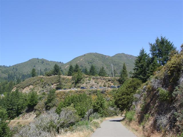
Up, up, up we went along the Dipsea trail. Paul Co was flying up the stairs, as this area was his old stomping grounds. Upon reaching the Panoramic Highway, I was finally able finish my coffee--nothing hits the spot after a long flight of stairs like a hot mocha. OK, it was actually a miserable mix, but I wasn't going to throw it away after waiting so long (and carrying it so far). Not much later, we reached the Sun Trail, which we have passed many times while doing the normal double Dipsea hike. This time we took the "new" trail, and just as Paul Co had already informed us, it was quite gentle. Along the way, we passed the Tourist Club, a locally famous Bavarian-style lodge. I learned later it has a biergarten with a full range of German beers on tap, and a large deck for picnic lunches. Next time we are in this area, this will be part of the hike for sure.
I wasn't sure if the hike would be a level four, but had read an account of the Temelpa Trail--our main route to the peak--being quite direct (i.e. steep). High-balling the hike difficulty didn't seem to scare anyone, considering 22 people showed up. When I handed out the maps, I drew the route taking Gravity Car Road to Temelpa, but on the other side of the paper, I printed the more detailed map from Marin Municipal Water District which showed additional trails. I suggested everyone look at that better map because (1) we'd need it when we were helplessly lost out there {the trails were reputed to be poorly marked} and (2) I planned to take one of the trails on that map (Vic Haun), which wasn't on the first map. Would anyone listen to this advice (or even look at the map)? Read on.
The front-runners were kindly waiting near the section of Redwood Trail that runs under The Mountain Home Inn. This is a significant detail because the people who didn't follow the (first) map closely skipped this short section of trail and hiked along the road over our heads. The result was several of us waiting a very long time, wondering where everyone else was. Actually, only Walter, Edita, Randy, and I waited--the rest got impatient much sooner. Eventually, we gave up too.
Much later, we caught David and George. As we surmised, they had unwittingly sneaked by overhead. As we discussed this, George pointed out an unmarked trail heading out of the fire-road junction where we were standing. We discussed the routes for a little bit (while Edita took off down the fireroad) and realized that this was the Vic Haun trail we wanted. Excellent! Randy said, "Aren't we going to go get Edita?", but she was already long gone. Sometimes it pays to stop. Not often, but sometimes.
So up the trail we went. I was trying to hike fast to catch up with the middle of the pack. The only person I caught was Bruce, who had also taken the Vic Haun trail, leading me to believe everyone (except Edita) had wisely taken the correct route.
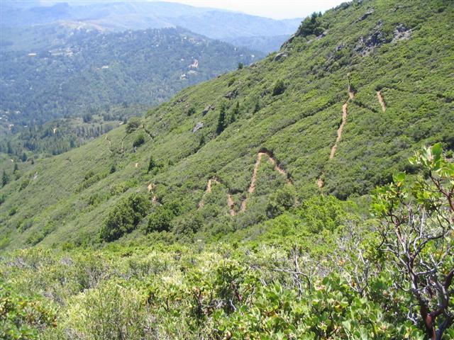
The famous Temelpa trail was not nearly as steep as advertised. The reason became clear after a while--every once in a while, near a turn in the switchbacks on the far-right sections, there would be a few stone steps, and then the trail would switch back the other way. Looking closely, you could see that the stairs used to go straight up the side of the mountain, but they added tons of switchbacks in between. Well, that was a welcome relief, but it made the hike easier than it would have been otherwise.
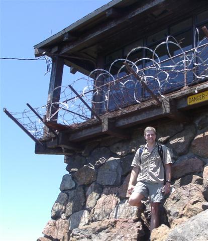
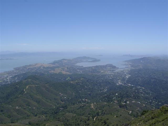
Near the summit, I followed the path I had drawn on the map by going right on the paved trail that circles East Peak. This was a mistake of sorts, as it goes 3/4 of the way around before one can access the trail to the summit (although the views were quite nice). On top is a short (and heavily barb-wired) watch tower. People were laying all over the rocks, as well as in the shade of the tower. However, I couldn't find anyone from the INCH crowd. I looked around for a while, and a few minutes later, people started trickling in. As it turned out, besides our tail group and Bruce, everyone else had taken the Hoo-Koo-E-Koo Road to Temelpa, adding half a mile to their route. Another mystery solved.
While we all ate our lunches and kicked back, I floated the idea of downgrading the hike to a 3. Everyone agreed it was pretty easy, so there was surprisingly little dissension (a first!). Switchbacks made all the difference.
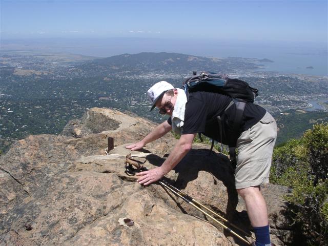
The last ones to the top were Jean Paul and Steve Wi. By that time, Gwynneth and Yipeng had already started back, and several other people were in a big rush to go. These are the situations when some of that Sierra-Club rigidity would be nice, but what can you do? I bid adieu to Jean Paul and Steve Wi and we headed on down (stopping to touch the marker and take pictures). By the time the last of us was down, 3/4 of the people had already set off. Chaos!
Caught up to Gwynneth on the way down Hogback Road, who said Yipeng (key holder of my carpool) was long gone. Hogback ends outside the Mountain Home Inn, where Bruce and Ondine were waiting. Bruce was meeting someone there later, so we all went in for drinks. Gwynneth came in a couple minutes later, as did Wennie, Rick, Oliver, and Davey. Some of us had a beer (thanks Bruce!), and then we were off again--all hikes should have a "beer check" like this, reminiscent of INCH's ancient hashing roots.
The hike down through Muir Woods (Ocean View Trail) was great--shady and beautiful. It was also full of people, much like the rest of the Mt. Tam area. We lost a bit of altitude going through Muir Woods, so there was a little bonus uphill hiking to get back up to the Panoramic Highway ridge. During this section, I learned interesting tidbits about the World Health Organization from Ondine. Hiking is educational!
It was great to reach the bottom of the stairs. Many people were already there, and it sounded like everyone took the right trail through Muir Woods. We waited around for a while until most of the carpools were reunited. People were spread out unusually far on this hike (heck, we stopped for a drink and still had some people behind us). David was the last one back, and reported that he ran into Jean Paul and Steve Wi, so everyone was accounted for. David added an extra three miles getting lost on the way back from Muir Woods. D'oh!
Another successful new INCH hike is in the books, officially removing Marin County from the list of California County Highpoints.
Milestones:
Highest point in Marin county
Gwynneth's 50th leaf
JP's 1st leaf
Ramesh's 10th leaf
Randy's 1st leaf
Steve Wi's 1st leaf
![]()
![]()
Pages maintained by Steve Walstra,
Peter Saviz, and
Russell Gee.
©2026 Intrepid Northern California Hikers