
| Main Page | Diary | Leaves | Stats |

630. Pogonip Route (08/09/08)
Hikers (14): David, Diane, Don M, George, Harvey, Janice, Kim M, Nani, Paul, Peter M, Ross, Sarah, Steve, Tracey
Distance: 25 miles
Rating: 4 difficulty, 7 beauty
Park info: Henry Cowell State Park near Felton
Write-up by Steve and Diane M -- Pictures by Steve and Harvey
Many moons ago, George pointed out that one could hike from Henry Cowell to Wilder Ranch and back. At the time, the idea seemed too linear. While looking for new hikes recently, this general area showed up as long neglected, so I looked back into it. We had never been to Henry Cowell (except the northern Fall Creek unit) because, well, it's pretty small. We also hadn't been back to Wilder Ranch State Park since our first visit almost five years ago because it's not tough enough for the long drive. But together, they looked to make a respectable hike. And so a new hike was planned. . .
1-2-3 INCH!
We had a new hiker show up--Tracey--who turned out to be a docent for Henry Cowell. What could be more embarrassing than a docent-led hike? Not too far after the redwood grove, I turned off to do a geocache. When I got down to the Diversion Dam area, which I had lovingly highlighted on the map, only Tracey and Don M were there. "Is everyone else across already?" Nope, turns out that only the three of us had gone the correct way. The other mooks had ignored the signs and took the Big Hole trail all the way to the river.
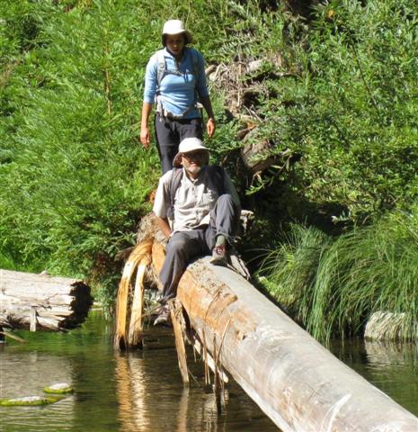
Ah, the river. I had a promised a river crossing, and had come prepared. Don M was already crossing when I got there, and despite being quite tall, he declared it too deep when the water reached his waist (and looked to get deeper). He came back to shore. Seeing that, I suggested we go over to a rocky area, and he and I crossed over there, while Tracey crossed the river proper. When I got to the other side, Don M was putting his boots back on. I climbed over a pile of logs and some rocks to get the other side (since I was wearing water shoes) and was surprised to discover a big pool of water still left to go through--glad I hadn't changed into boots.
Changed back into boots and waited until Tracey came up from the sandy beach. I yelled for Don a few times (I had seen him less than 30 yards away), but he didn't respond, so guessed he must have either (1) headed up ahead of us already or (2) passed out at the small pool (which seemed rather unlikely). That was the last time I'd see Don. . .
There was a steep trail going up from the beach, so I asked Tracey if it was the right one. "Sure!" As we went straight up, I said, "This can't be right--it's just going to go up to the railroad tracks." And so it did. But that wasn't so bad, because there is a nice trail along the railroad tracks. Although unmarked, two joggers passed us at different times--seems to be a popular trail.
As we were approaching the point where Rincon Fire Road crosses the railroad tracks, I could see many INCHers crossing the tracks ahead. I sped up to catch them--that was the last time I saw Tracey during the hike. . .
While passing, I couldn't resist pointing out that everyone had taken the wrong trail. Of course, I also hadn't taken the correct trail, but at least crossed at the right location! Was wondering why they were not farther ahead, but apparently there was a long wait for Nani to cross a log.
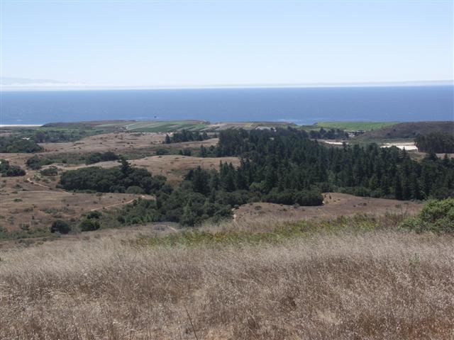
The trip through Pogonip and UCSC was not particularly exciting, and soon we were in Wilder Ranch State Park. Around this time, George took off. He had a reunion of some sort to attend, so was in a rush. That was the last time we'd see George. . .
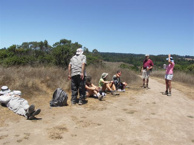
While wending through the poorly signed Wilder, one big group formed consisting of Harvey, Janice, Kim M, Nani, Paul, Ross, Sarah and me. We did the hike as "drawn", with a little detour selected by Janice and an even shorter detour selected by me. In general, the signs are either missing or misleading, although with a map and some concentration, one can piece it all together. So it wasn't too long until we made it to the official lunch spot at the Overlook point on the map.
We waited at the overlook for a long time, speculating on the whereabouts of missing parties. . .Peter M showed up, letting us know that Tracey was right behind him, and had probably missed the short detour up to the Overlook point. So that accounted for everyone except the three D's--acceptable losses.
The way back was pretty uneventful, although there were some interesting ruins along the Engelsmans Loop. Some of us took a little different route back through UCSC, and no one took the detour to visit the scary club house (link gone) in Pogonip. Maybe next time.
Much later, I ran into Ross near the river in Henry Cowell (shortly after a fire engine passed on Rincon--guess that's why it is a fire road), who was coming back from an unsuccessful search for his morning wood (i.e. the log). So we decided to take Rincon Fire Road across the river. When we got to the crossing, we were greeted (indirectly) by a topless woman and her boyfriend in the river. We couldn't see any trail on the other side, so weren't sure this was the right spot. I was willing to go anyway, but Ross convinced me that if there was no trail on the other side, it would be a lot of bushwhacking to find it. So we turned around and headed for the Diversion Dam Trail (which I had mostly bypassed in the morning). We ran into Paul, who continued down to the river to check out the views.
The Diversion Dam Trail worked just fine, and I already knew where to cross, so it went quickly. We waited for Paul, who did not see us take a right after crossing the river, and so headed off in the wrong direction after crossing (but he figured it out eventually). From there, it was straightforward going back. . .except for the fact that the trail(s) back to HQ are often marked simply as "No Bikes" (the trails aren't named, but they are marked). Again, careful reading of the map works, but generally the signs suck in both the state parks (signs in Pogonip and USCS were fine). Back at the cars, Harvey, Sarah, and Kim were already back, having found the famed log crossing.
We enjoyed some beer while people slowly made it back. Tracey mysteriously appeared later, coming from the vicinity of Roaring Camp. When I had to leave, the same three people were still not back: David, Diane M, and Don M. However, several people had run into Don M coming down Engelsmans Loop (when we were going up), and declared that he had turned around. That was good to hear. So, what happened to David and Diane? Read on:
David and I mistakenly took the far side of Wilder loop, which led us far astray into the wilds of greater Santa Cruz. This side of Wilder trail was very narrow, pleasant and bucolic, and David much preferred it to what he later imagined would have been the correct trail. I was enjoying it quite a bit myself until we came a little too close to a horse farm, where wind conditions were ideal to nearly overcome us with the stench of horse manure. This of course interrupted the deep soulful (?) conversation that had preoccupied us until then and jarred us into checking the map. Spying a nearby trail marker, we realized we had ended up near the ocean miles away from where we were meant to be. Being good, resourceful INCHers with a deathly fear of black leaves, we chose to hike parallel to the ocean and pick up the official route rather than calling it a day and going back home. In hindsight, we underestimated how far off-track we had gotten.
The trail parallel to the ocean continued to be pretty and pleasant, reminiscent of 'Christina's World,' but offered little shade for a lunch stop. The time was now approaching 1:15 p.m. While I had no concerns for myself with my superior genetic makeup particularly designed to withstand intense sunlight, heat and global warming in general, I was somewhat worried about David with his husky white Idahoan heritage. I kept pointing out the most shady, least poison-oak infested spots I could find, but David rejected them all, feeling they were not appropriate venues for his fine dining standards. Finally, however, he realized the options were not going to get any better and graciously acquiesced to my suggestion of eating under a small tree, even offering me some of the meager shade, so that I could enjoy my gigli pasta with baby arugula and sauteed mushrooms while he consumed Gu.
We did eventually reach Engel-something trail, which was the prescribed route back from the ocean, and plodded up the relentless incline underneath the blistering sun. Again, I had no concern for myself, but David was drinking inhuman amounts of water. Strangely, David enjoyed the uphills, far preferring them to downhills or even flat sections. Those Idahoans sure are some strange puppies. After what seemed like miles (and actually was miles), we came to the intersection with Long Meadow trail. David took this opportunity to hydrate yet again while I was silently, or perhaps loudly, grateful that the right turn onto Long Meadow appeared to be flat for a change. However, that was a cruel trick of nature, as a steep long uphill loomed ahead of us just around a curve. I got my first scary glimpse into David's sadistic side as he taunted me with how much he was going to love the nearly vertical climb. Finally, I just had to run up the hill in a desperate bid to make it to the top and get away from David's cruel jeers.
Thankfully, Long Meadow really did flatten out after that last seemingly endless uphill, and David reverted to his usual mild-mannered self that we all know and love. We crossed out of Wilder Park into Pogonip or UCSC park -- who can keep track? -- and headed down Chinquapin trail. As we entered the redwoods, David's energy began to fail so we sought a good resting spot for him to re-fuel with more Gu and Jolly Ranchers. He kindly shared a blue raspberry Jolly Rancher with me and I have to say, I don't see what all the fuss is about. Maybe they're an acquired taste. I too needed a quick break to heed the call of nature, having drank an entire 8 ounces of water over the preceding couple hours. Given David's and my preoccupations with, respectively, Gu-ing and peeing, we completely missed the left junction with Fuel Break Trail that would lead us to the U-Con connector, back to Rincon Road and civilization.
Continuing down Chinquapin, a few minutes later we found ourselves at a series of bldgs and a fire station that seemed recently and eerily deserted. Since we knew we had not passed these buildings before, we retraced our steps and David found the Fuel Break junction in the *wrong* direction, going towards Spring Trail (not shown on Steve's map) and away from what I sensed with my instinctive navigational abilities was the general direction of U-Con Trail. Given the hour, I realized the time for fun and games was over. I tapped into my inner alpha male and informed David that Spring Trail was the wrong direction (who says I can't RTFM?) and we were going back to the fire station to find someone and ask for directions (because women don't mind doing this). Still weak from hunger, David submitted to my will. While the fire station was still deserted -- maybe all the firefighters needed a rest after the conflagrations of the last several months -- there was a large, beautiful, detailed map on the door that convinced even David that Spring Trail was the wrong direction. (David, feel free to thank me any time that you like.)
Well, thanks to my superior navigational abilities (did I mention those already?), we did find the correct Fuel Break junction in the direction of U-Con Trail and headed back to Rincon Trail. I think David was getting delirious by this time as he kept asking if anything looked familiar, even though this portion of the route we had correctly come through in the morning. By the time we crossed Highway 9, David had all but left himself in my hands, barely pretending to look at my map when I indicated which way we needed to go. In the morning we had absent-mindedly followed others an incorrect way to an river crossing which practically required log-rolling skills. Since we didn't need any such adventures on the way back, I knew I had to take charge and RTFM; fortunately, I am very good at this when people's survival requires it. (David, feel free to thank me again.)
We reached Diversion Dam trail, where in a moment of weakness, David suggested we shortcut by remaining on Rincon Road. Knowing his deplorable mental state, we forgive him this transgression. Fortunately, I was strong for both of us and insisted we stick to the official route and also not chance untested shortcuts at this time, and brought us to a river with a strangely Blue Lagoon feel: there were a number of shirtless healthy-looking youths in the prime of life frolicking in the water and chasing gigantic 8-inch crawdads w/3-inch pincers. Being a woman, I of course walked up to them and asked for directions, and we eventually learned both that there was a promising trail that picked up on the other side of the river and that we could walk upstream a bit and try to cross the river by jumping across a chain of rocks. I was very relieved about the latter news in particular, as I neither wanted to repeat the log-balancing trick from the morning, nor wanted to wade through waters infested with vicious man-eating gigantic-pincered monstrous crawdads.
On the other side of the river, David informed me that it was now 6 p.m., later than I expected and getting a bit dark with all that redwood cover. Unbelievably, I had a flashlight with me! David was astounded (and relieved)! I was astounded (even though I had put it there myself the previous evening)! What have I become that I now instinctively throw a flashlight in my backpack before a long hike without anyone instructing me to do so? Much like Scientology, INCH is a very insidious organization for the unwary innocent such as me ... I guess this means I can no longer feel smug towards Katie Holmes. As we headed uphill along the unmarked redwood-darkened trail from the river, I got a second glimpse into David's deep dark sadistic side as he tried to scare me with eerie vampire noises. Fortunately I have never seen 'Lost Boys' so he had minimal impact on my fear level. I was however nervous that we may not have caught the right path as we hadn't seen any trail markers and the Blue Lagoon kids had no idea where the path actually went.
Much to my relief, after less than a mile, we came across signs pointing towards Rock Hole Trail. We were going to live! I was completely energized by this discovery and ready to skip all the way back the car, but David was being quieter than usual. His feet were hurting and he hadn't really perked up at all since the last Gu break some time ago. While I offered to hoist him on my shoulders and carry him back if he conked out -- but only if he was still breathing, we agreed that dead carcasses were not worth saving -- I figured I needed a better plan because, let's face it, David's a big guy and I'm not so strong. Fortunately, David unknowingly gave me the solution by bringing up disco-era hits ('I will survive,' 'We are family,' etc.) in response to my enthusiasm about finding Rock Hole Trail. That was it - David and I could pass the time by boogie-ing back to the parking lot! Truth be told, David did none of the singing or dancing during that last hour, but he was a fabulous audience for my song-and-dance rendition of 'Staying Alive' and other great hits from the '70's. I sing terribly off-key but I think David's feet were in such pain that he was grateful for any distraction. I was almost sad when it had to end. (David - I hope you know what good friends we are that I sang for you. Most people, I would just let die on the trail rather than sing them back to the parking lot.)
Of course, the real hero in all of this is poor Kim, who had patiently and uncomplainingly awaited my return back at the parking lot at 7 p.m. I fear she will never carpool with me again.
Milestones:
Diane's 70th leaf
Harvey's 80th leaf
Steve's 490th leaf
Tracey's 1st leaf
![]()
![]()
Pages maintained by Steve Walstra,
Peter Saviz, and
Russell Gee.
©2026 Intrepid Northern California Hikers