
| Main Page | Diary | Leaves | Stats |

687. Rock Springs Peak Loop (08/15/09)
Hikers (10): Chris R, David, Diane, George, Karl, Kirk, Linda L, Paul, Ross, Steve
Distance: 20 miles
Rating: 5 difficulty, 8 beauty
Park info: Henry Coe State Park near Morgan Hill
Write-up by Steve -- Pictures by Karl
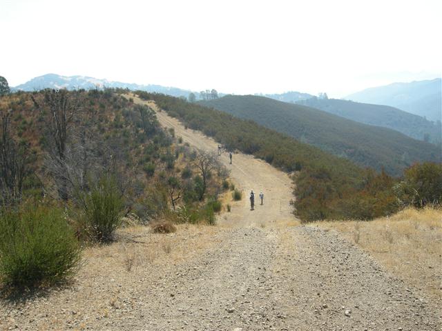
Ten people showed up for a new hike out of the Hunting Hollow entrance at Henry Coe. The original plan was to start in Dowdy Ranch, but it was closed for the season due to budget cuts. In the end, we had the entire south side of the park to ourselves, seeing only a few equestrians the entire day.
1-2-3 INCH!
Goal number one was to take the Jim Donnell Trail, a little used that connects back with our standard Steer Ridge route to Willson Peak. The sign for the trail was off to the side, but the map clearly indicated we had to take a left almost immediately after leaving Hunting Hollow. I headed up the hill, then looked back and watched as every passed right by the sign. Ross at least took a look at it, but he couldn't break himself from the train of people going straight. So I waited just a little longer before calling everyone back.
The trail was flagged (as in "had little planted flags") all the way up--apparently there was some trail work planned at one time. The front runners ran into the middle of the pack about halfway up. Those guys had missed all the nice switchbacks and went right up an unflagged (!) use trail. I waited for the stragglers, which took quite a while. To their credit, they took the correct trail. After that I set off to try to catch the front runners. . .and do a little geocaching.
It was a nice hike along Center Flats Road--first time INCH had ever crossed Center Flats. Later on, David caught up to me at the crucial Dormida Trail junction. I had gone down the trail a little to make sure it worked, and came back to make a big arrow, complete with shiny white-rock head. The elaborate arrow was because the Dormida Trail was (surprise) unmarked and mostly out of use, despite being labeled on the map and reasonably close to Dowdy Ranch. I had mentioned at the beginning of the hike that it might be hard to find, and suggested people wait if it wasn't clear. I was pretty sure the front group had missed it and was scratching their heads down at Dowdy Ranch, so David and I headed on down the trail thinking we were the front runners.
The trail petered out the bottom, but its intersection with Vasquez Trail was obvious, and I had a waypoint to back it up. From there, we headed up Vasquez trail to Rock Springs. Rock Springs Peak was another goal of this big loop. We had never successfully visited the "real" peak. [See the thrillingly controversial story on Rock Springs Peak below]
David showed up as I came back from the peak, and he headed up after me. Since no one else had waited, I was certain everyone else would all miss it. I put a helpful arrow pointing to the peak.
Long story short, the front running group did find Dormida trail on the first try and missed Rock Springs Peak--so they were all in the parking lot when I got there. George convinced some people the peak was at the same place as our last visit, despite the fact that it was circled on the map as being on the other side of the trail. What more can I do? The trailing party (Linda L and Paul) saw my arrow at Dormida and made the whole hike. They also saw the arrow at Rock Springs Peak and still didn't go to the peak. I would black leaf them, except that I'd have to black leaf everyone but David in that case, and that would be too much considering everyone hiked 20 miles on a fairly warm day!
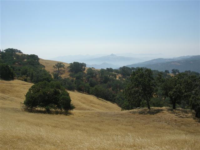
All said, it was a great loop--definitely worthy of a repeat some day. Center Flats was, predictably, not flat at all. It was a rolling ridge line with great views and a nice remote feeling.
Many years ago, I decided to extend our Vasquez Peak hike out to Rock Springs Peak. By then, I had Topo software and the great free "line maps" from Bill Levey. Based on that map, Rock Springs Peak was on the left hand side of Vasquez Road coming from Willson Camp. I used this position on my GPS to declare the peak "bagged" at the time.
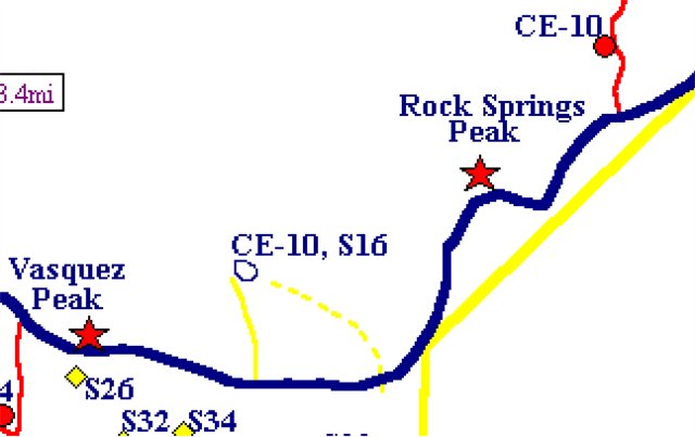
This location is similar to the what the USGS topographical map shows, although the topo map is vague on the location of the peak. It appears to call the whole area Rock Springs Peak.
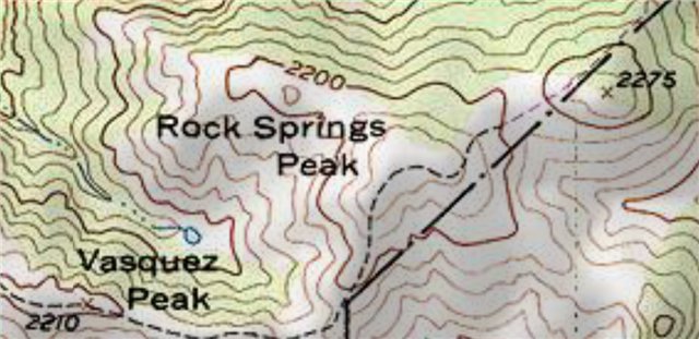
The latest Henry Coe map, however, designates the 2275 ft point from the topo map as Rock Springs Peak. This puts the peak slightly outside the park boundary. It is a great summit, surrounded by dense oak trees with a real summit block. It is a much better choice as a peak, and is is consistent with Vasquez Peak as far as having a surveyed "x" on the topo map.
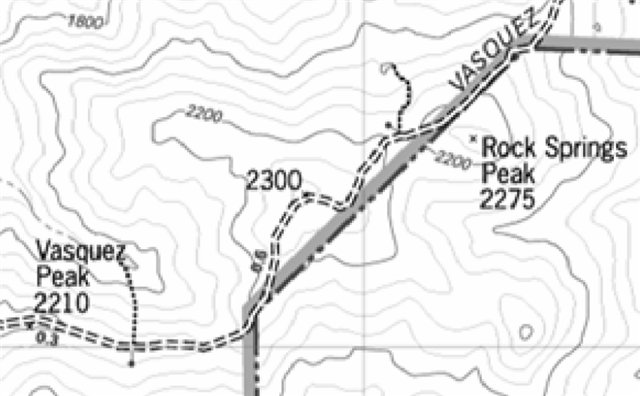
The actual Rock Springs, after which the peak is named, is between the two points (and can be seen on the first and third maps). Thus, it doesn't help determine which peak is The Peak. So which is it? I'm going with the new Coe map, with the argument that if you are going to call something a "peak", it should be peaked. This is consistent with the naming used for Bear Mountain and the separate Bear Mountain Peak in the NE part of Henry Coe. When in doubt, visit them both.
![]()
![]()
Pages maintained by Steve Walstra,
Peter Saviz, and
Russell Gee.
©2026 Intrepid Northern California Hikers