
| Main Page | Diary | Leaves | Stats |

78. Ridgeline Trail (07/19/98)
Hikers (7): Eugene, Jamie, Mary, Peter, Pistol Pete, Russ, Steve
Distance: 7 miles
Rating: 3 difficulty, 8 beauty
Park info: Pleasanton Ridge Regional Park west of Pleasanton
Write-up by Peter
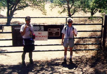
A week after the butt-kickers at Yosemite, we decided to do something a little more down to earth and closer to home. The hiking bible recommended the Ridgeline Trail in Pleasanton Ridge Regional Park for a quick, moderately-difficult hike. Sounded like just what the doctor ordered.
1, 2, 3, ... INCH!
The trail looked straightforward - up some switchbacks to the top of the ridge, followed by a 3-mile stroll along the ridge to the peak at 1600 feet, then return along a parallel trail and back down to the car. Piece of cake - the only thing that was going to make it somewhat of a challenge was going to be the heat.
It was already pretty warm as we started out and began heading up the Woodland Trail. It did not take very long before we started huffing and puffing. At least this part of the trail was shaded. I made the mistake of walking behind Eugene, who was kicking up a ton of dust, as usual. I tried to speed up and pass the little bastard, but he was just too fast for me. I have to say that he is definitely the most improved hiker this year.
Before too long, we were at the top of the ridge. The good news was that we had stopped climbing, but the bad news was that we were now out from under the shade and out in the open. It looked like we were destined to spend the majority of this hike walking under the midday July sun. Not a pleasant thought!
We trekked along the Ridgeline Trail. In addition to the heat, the bugs were also out in force and were adding to our misery. Esteban and Pistol Pete had separated from the pack and blazing trail up ahead. The rest of us trudged along, with Eugene leading the way. To say that we lacked motivation (especially Rusty and myself) was somewhat of an understatement.
Every once in a while, I would look down from the top of the ridge and see the cars traveling along Hwy 680. From up here, they looked like little toy cars, but I was thinking it would be great to sitting in one of them right now with the AC blasting away. Oh, man! I couldn't wait to get this damn hike over with.
We found ourselves coming to a gate, and then the trail began to head steeply downwards. It looked like we were heading straight down into a golf course. This didn't seem right, but none of us had seen any turnoffs or forks in the road, so we figured we must be on the trail and kept going.
About a half-mile later, we saw a marker indicating we had crossed over into Bernal Park. A quick check of the map showed that we were on trail, so we kept going. Thankfully, this part of the trail was pretty shady, so it was quite pleasant to walk along. We didn't mind this at all.
As expected, the shade did not last very long and we found ourselves out in the open once more. To make it even worse, we had to climb back up to the top of the ridge again. So much for an easy hike!
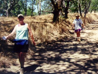
With about a mile to go to the peak, the pack began to separate, with Rusty, Eugene, and myself up front, and Jamie and Mary bringing up the rear. Let's get this thing over with!
We picked up the pace, and before too long found ourselves at the big water tank at the top. No sign of Esty and Pete. I figured they must have just kept going (the water tank is at about the midway point of the ridge and it's possible to keep walking for another 3 or 4 miles to the end of the ridge). Well, they both had maps and there was no real way to get lost in this park, so we unanimously decided to let them fend for themselves (I think the actual wording was more like, "Aaah - screw `em!").
We walked once around the big tank and then began to head back. A couple of
hundred yards down the road, we met up with the girls and sat down to rest
and take a couple of pictures while they headed up to the tank.
By the time they came back, Esteban had also showed up (he had gone about
a half-mile further up and then turned back). Still no sign of Pete.
We headed back on the Thermalito Trail. I'm not quite sure what "Thermalito" means, but it sounds like it has something to do with heat, and under the broiling noon sun, the name was certainly appropriate. The trail was not difficult, but just seemed to go on and on endlessly, with nary a tree or bush in sight. Thank God for sunscreen and water!
Mercifully, the trail finally ended and we switched over to the Olive Trail. From there, it was a quick stroll over to the Oak Tree Trail, and then finally back down the cars. Whew! The torture was finally over!
A few minutes later Pistol Pete also showed up (he'd also gone further up and then taken the Ridgeline Trail back in), and we hit the road. Time for a nice cold beer -- we had certainly earned it!
![]()
![]()
Pages maintained by Steve Walstra,
Peter Saviz, and
Russell Gee.
©2026 Intrepid Northern California Hikers