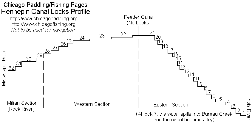
Hennepin Canal
(State of Illinois, U.S.A.)
|
We are not responsible for errors or omissions.
When boating, regardless of water depth, wear a PFD!
|
Father Hennepin was a Recollect missionary who traveled to Illinois with
Sieur de la Salle in 1681. de la Salle brought three missionaries with him on his journey and quickly
tired of Hennepin's constant requests to go exploring. As Sieur de la Salle prepared to go back
toward the Niagara area to search for his missing ship the Grifton, he decided to give Hennepin what
he asked for and told him to go find the source of the Mississippi. Hennepin set out with two assistants
(DuGay and Accau) and paddled down the Illinois River to the Mississippi. They then turned around and began paddling upstream.
After a few days, when they stopped to rest on the west bank, they were taken prisoner by
Sioux Indians. Hennepin was mercilessly tormented by one of the Indians (who was later admonished for
his actions by a Sioux Chief) for the winter. Hennepin and his companions were marched on a hunting expedition
and thus became the first Europeans to see the Falls of St. Anthony on the Mississippi near Minneapolis.
(Dams have now eliminated these falls.) Because Indians were
required to feed their prisoners, and Father Hennepin was a less than desired prisoner, he was almost
left behind at this point in the wilderness...as the group left in canoes, and even Accau and DuGay refused
to let him in their canoe. One of the last Indians to leave relented and let Hennepin ride in his canoe. Later
on the hunting trip, Hennepin, Accau, and DuGay decided to take one of the Indian canoes and escape. They
were afraid the Indians would pursue them, but they did not. Later when they encountered the Indians
again on the river they feared they would be taken prisoner again, but the Indians didn't want them as
prisoners and after expressing their displeasure that Hennepin lied to them, the Indians left and the three
men returned to the St. Ignace Mission.
Hennepin went on to write a book of his travels that was widely read. A few years later,however, he did something that would make him look foolish forever. After the deaths of Sieur de la Salle
and Father Marquette, Hennepin wrote a new book, one in which he claimed to have discovered the
Mississippi, its source, its mouth, the things that are still to this day credited to de la Salle and
Father Marquette. Henri de Tonti, Sieur de la Salle's Lt. Commander, who was still living in New Orleans,
wrote his brother "don't believe the rantings of the foolish priest". Some argue that his captivity caused him to lose his mind, others thought he was
politically motivated (he now lived in the Netherlands and Britain was seeking ways to renounce French
claims to the new world). Either way, it would damage his reputation forever...or at least for nearly
300 years.
The canal that now bears Father Hennepin's name started out as the Illinois and Mississippi canal.
It became the second I&M canal in the state of Illinois, but unfortunately, the era of canals had really passed even before it was built.
When the original I&M (Illinois and Michigan) Canal opened, commerce was able to travel past Chicago into the nation's interior, but
the I&M only went to LaSalle/Peru Illinois, and the Illinois River was not always navigable beyond. In 1894 work began
on the Illinois and Mississippi Canal, and it opened in 1907. But by then the I&M's heyday had already passed.
Chicago's Ship and Sanitary Canal opened in 1900, and with its 25 foot depth it could handle much bigger barges
than the I&M ever could. Also, Chicago's Sanitary District built locks on the Illinois at Henry and Coopers Creek to
help make the Illinois River navigable more of the time. Both I&M Canals (Illinois and Michigan and Illinois and
Mississippi) saw a brief resurgence in the early 1920's when Morton Salt decided to use the old canals and a few
older barges to transport its materials. Morton argued that we didn't need a deepwater channel to the interior and
that the smaller barges were fine. In the end, the deepwater channel ended in Lockport, the Army Corps of Engineers
took over the Illinois Waterway project when the state ran out of money, and there is now a 9 foot channel in the Illinois River from Lockport to the Mississippi. Not very deep, but deep enough to make the Illinois and
Mississippi Canal a footnote.
The Illinois and Mississippi Canal's locks closed to traffic in the 1950's forever.
In the late 1960's, it was decided to open the canal to recreation, and for whatever reason, it was also decided
to rename the canal in honor of Father Hennepin. Perhaps time had rehabilitated his shaky reputation.
The Hennepin Canal State Parkway opened in 1970. Although the parkway is not very wide -- only 100 feet on either side of the canal in most places -- it's fairly long -- over 100 miles.
05/15/99 Camped in Tiskawla. The aqueduct bridge replacement is
assembled and ready to be installed as soon is it's dry enough.
04/98 The aqueduct bridge was destroyed by spring floods between
Locks 11 and 12. Check with the rangers before planning on biking from
Sheffield to Tiskawla.
Opened as a recreation area in the 1970's, the Hennepin Canal State Parkway offers over 100 miles of bike, hiking,
horse and canoe trails. The water is maintained at a depth of 5 feet. (At some places along the canal you'll see a small
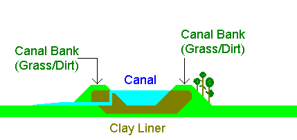
concrete box and hear the sound of water rushing...it's going over that box to a creek below). The canal is mainly a
perched or diked canal, with embankments on each side and a clay liner to hold the water in. Most areas are not dug and
you'll need to use care to not walk off the edge of the embankment on the side away from the canal (this area is often
hidden with trees and brush so that you don't notice that it's a 10 foot drop).
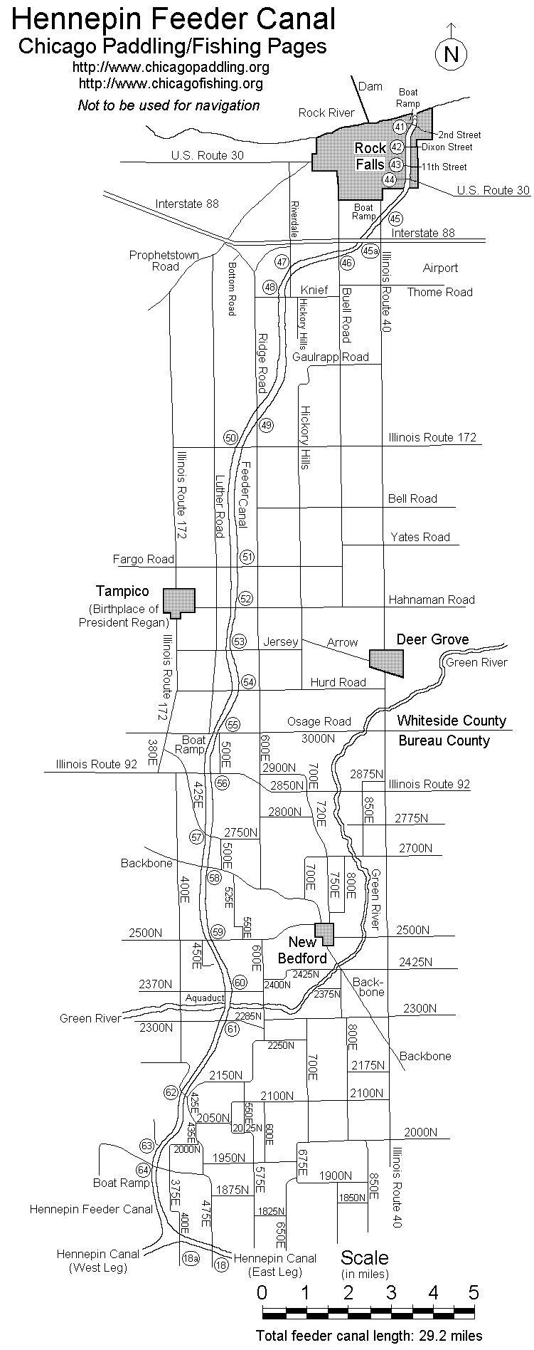
Boat ramps that can accommodate trailered power boats:
See maps online shortly
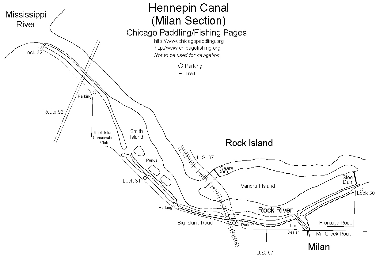
- Bridge 45, (Near Route 40, Rock Falls) Concrete Ramp
- Bridge 56, (Route 92) Concrete Ramp
- Bridge 64, Concrete Ramp
- Bridge 39, (Geneseo) Gravel Ramp
- Lock 24, Concrete Ramp
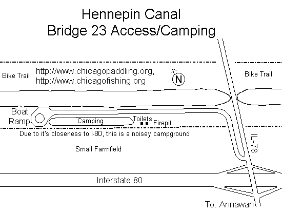
- Bridge 23, (Route 78, Annawan) Concrete Ramp
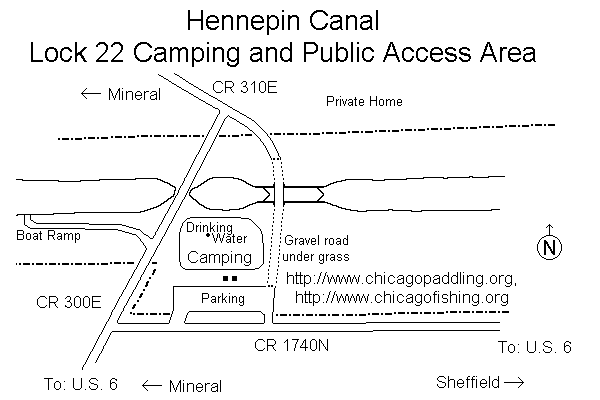
- Lock 22, (off Route 6, Mineral) Concrete Ramp
- Visitors Complex, (east of Route 40, Sheffield) Concrete Ramp
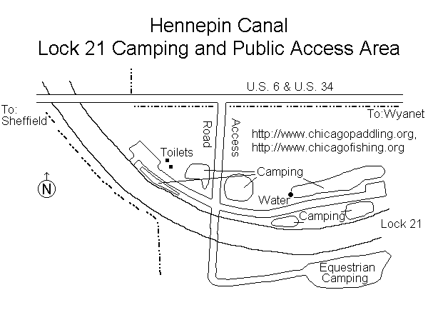
- Lock 21, (Near Route 6 and 34, Wyanet) Concrete Ramp
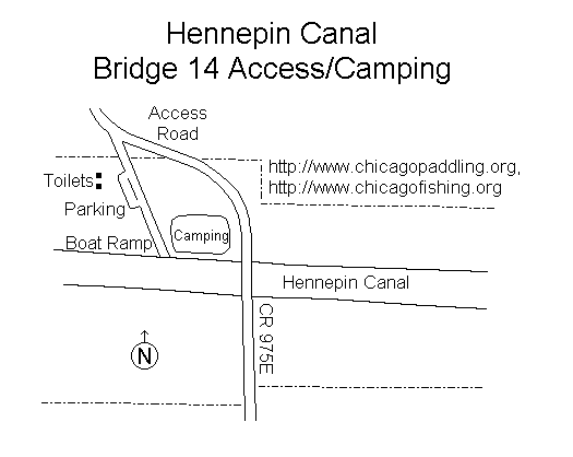
- Bridge 14, Concrete Ramp
Canoe/kayak access at: (carry-in dirt access)
See maps online shortly
![[Pic]](hen1200.jpg)
Going thru the tube near Sheffield
![[Pic]](hen3200.jpg)
The drawbridge at Lock 22
![[Pic]](hen5200.jpg)
My tent, sinking in the canal after the wind picked it up near Anawan
(We rescued it)
![[Pic]](henn2.jpg)
The canal at sunset in early spring
![[Pic]](henn3.jpg)
Lock 8
![[Pic]](hennlock.jpg)
Lock 8
| Canal Access and Fishing Maps
|
- Private power boats, canoes, rowboats allowed.
- Outboard motors permitted. (10hp max)
- Boat ramps are gravel (both above and below waterline).
- Locks/Dams
- Rentals are available from Canal Area Tackle (Wyanet), (815) 878-6822
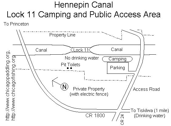
- Lock 11, Tisklawa
- Bridge 14, (between Sheffield and Wyanet)
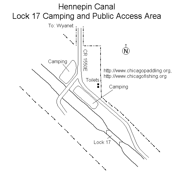
- Lock 17, Wyanet
- Lock 21, (Near Route 6 and 34, Wyanet)
- Lock 22, (off Route 6, Mineral)
- Bridge 23, (Route 78, Annawan)
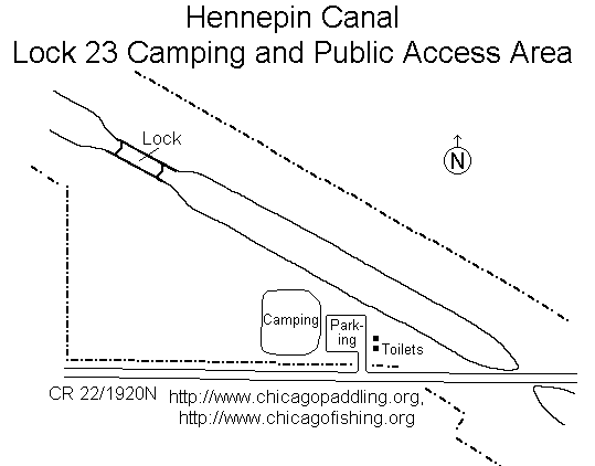
- Lock 23, Atkinson
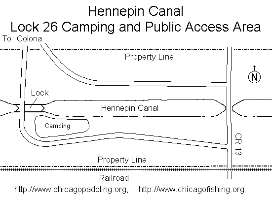
- Lock 26, Colona
Fish in this canal include:
They have netted off the lagoon at the visitors center in Sheffield,
IL and have stocked it with Trout. Trout Season opens at 5am, October 21st. 07
The visitors center is located just south of Interstate 80, and just east
of Illinois Route 40 (I-80 exit number 45)
No, it's not a fast-moving river, it's not even a natural stream,
but the Hennepin Canal offers something that most waterways in
Illinois can't, quiet. This canal runs across Illinois from
Bureau, IL (where the Illinois River turns south) to the Rock
River (near Moline,IL). There is also a feeder canal that offers
30+ miles of no portage travel between Rock Falls,IL and the
Hennepin Visitors center.
The Hennepin canal is slow moving brown
water. The sections near the locks have a little bit of current,
farther away from the locks there is not really any current at
all. The water is covered with swirls of algae. Birds are
everywhere. Great Blue Herons are quite common. There are so
many waterbugs on the water, that it almost looks like rain as
they dance from spot to spot, searching for food on the water.
I started at Lock 22 and headed westward. I only met one boat, a
fisherman in a row boat with a small trolling motor near Annawan,
IL. Portage at the locks is a bit tricky as they don't have sand
or dirt beaches and you have to guess where the tall grass ends
and the water begins, but you know real quick if you made a
mistake.
The state maintains the canal at about 5 feet deep. Every once
in a while you'll see a small concrete structure near the edge
of the canal. These are siphons that drain off the water from
the canal to keep it from overflowing. Many creeks are in the
area, and the water is siphoned off into them to help keep the
canal within its banks. Completed too late to become a major
canal, the canal was too shallow and too narrow for the larger
barges that now travel the Illinois River thanks to Chicago's
Ship and Sanitary Canal. Unlike the I&M Canal, this was never
a sanitary canal!
Some sections of the canal are excavated, but most have levies
on each side. The ground is sometimes overgrown on the edges
so that the edges are hard to see (when biking with my scout
group earlier this year, my son rode off the edge, when the
scout behind him saw him disappear, he tried to stop, but
ended up in a thorn bush at the bottom of the 6-8 foot drop,
my son managed to stay on his bike and rode back up the hill
about 30 feet away).
If your looking for a change of pace, the Hennepin is about a
2 hour drive from Chicago via I-80.
Hennepin Canal Water (Bureau Creek/East Section) Quality Information (Illinois EPA)
Hennepin Canal Water (Green River/Middle Section) Quality Information (Illinois EPA)
Hennepin Canal Water (Rock River/West Section) Quality Information (Illinois EPA)
![[Pic]](hen1.jpg)
![[Pic]](hen3.jpg)
![[Pic]](hen5.jpg)