
| Main Page | Diary | Leaves | Stats |

615. Skyline National Recreation Trail (04/26/08)
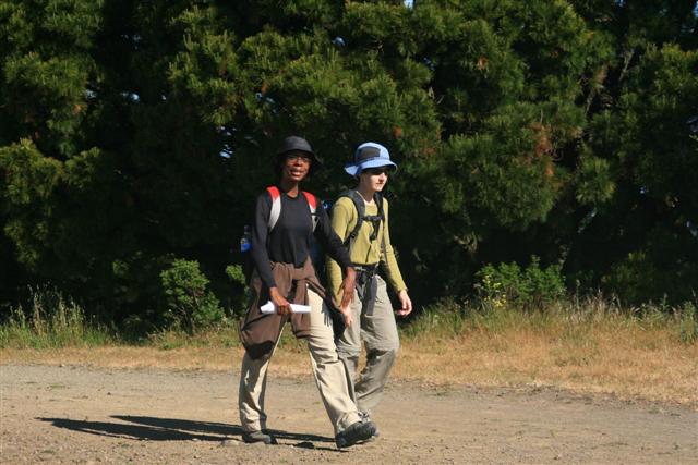
Hikers (17): Cecilia, David, Diane, Eric F, Eugene M, George, Gladys, Harvey, Helen, Iyad, Linda L, Nani, Ross, Sabine, Sarah, Silviu, Steve
Distance: 32 miles
Rating: 6 difficulty, 8 beauty
Park info: East Bay Regional Parks near Oakland
Write-up by Steve -- Pictures by Silviu
Big thanks to Russ, Clive, Rudi, and Kirk for getting up extremely early and shuttling us from Castro Valley to Richmond. Hopefully they went home, slept some more, rolled out of bed around noon, and laughed knowing we were still out hiking. . .
We got a bit of a late start because long-time East Bay resident Linda couldn't find the meeting location. The grumpy people who can read maps were anxious to start the hike, so demanded a vote on if we should wait any longer (after suffering a 20-minute delay). The vote wasn't close.
Luckily, one shuttle made a pit stop so that the second-latest person (Helen) could get coffee, during which time Linda was spotted. Russ jumped into her car and helped navigate to the start of the hike. . .so much excitement, and we haven't even gotten to the hike.
1, 2, 3 INCH
The later 6:57am start time was still plenty early. The initial hike up Belgum Trail, which I realized for the first time after five visits is not Belgium Trail, is one of the few steep hikes along the route. That spread people out a little, but not too much, as everyone was full of energy. Wildcat Canyon and adjacent Tilden had lots of great views of San Fran and The Bay from the ridgeline. The hike featured three "extra credit" peaks along the route. The first was Wildcat Peak, the peak with the best view (and a fancy circular stone structure). On the way down, was happy to see all the INCHers coming up.
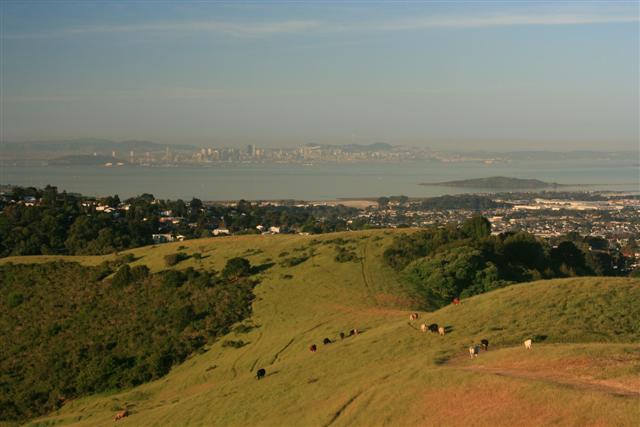
Tilden came and went, and soon I was going down Arroyo Trail to pick up Vollmer Peak Trail and the spur to the peak. The trail is nice and steep, and the peak is surprisingly flat with plenty of towers. You can still see the Bay from here, but it's not as nice as Wildcat (although there is something to be said for the shade). On the way back down, I only saw George and Eugene.
The first time we hiked this trail, it was hard to find the trail across the EBMUD land which connects Tilden Park to Sibley Park. However, just like two years ago, it is well marked now. Just look for those "East Bay Skyline" markers and don't enter any trails that say "Permit Required". Too easy. The coolest part about this section is that it passes over the Caldecott Tunnel.
Sibley has all sort of cool volcanic stuff, but its highlight on this long trail is dependable water. It also contained our third optional peak: Round Top, part of a 10-million-year-old volcanic complex. I carefully followed the map to avoid hiking to the water tank as I had last time. Because I didn't want to miss 0.03 miles of the official trail, I dutifully took a tiny connector trail that essentially loops back to the road leading to Round Top peak. Unfortunately, I went the wrong way off this unsigned route and strolled along the Volcanic Loop Trail. I was enjoying the hike thinking, "Man, this is so much easier than I remember. . .but isn't the road paved?" This kept going through my mind, because I knew there were towers on top, so surely this rocky road couldn't be right. About a quarter mile into it (with no elevation gain) I realized I must be on a different trail, and turned back. . .Took a picture with my cell phone atop Round Top to document the "trifecta" and headed back down. Curiously, didn't pass anyone in either direction, despite the detour. Did people end up on HWY 24 again?
The next park on the route is Huckleberry Botanic Regional Preserve, which was widely regarded in post-hike discussion as the best park. Not much to say except that it is full of scenic streams and lots of ferns. Very Jurassic.
Next is Redwood Regional Park, the last stop for water along the trail (and 16 miles short of the end of the hike). Had to keep pushing a dog away from the water as I was filling up my Camelback. The owner told me her dog only drinks water out of the tap (i.e. not from a bowl). That's wise, since the dog kept putting its paws in the water dish under the tap. . .wouldn't have minded cooling my paws, too.
The Redwood map has the annoying feature of displaying the East Bay Skyline (EBS) Trail and the Bay Area Ridge (BAR) Trail with the same triangular icon. The trails diverge at one point, where the EBS trail takes the French Trail and the BAR trail continues along the West Ridge Trail. Every time we come here, I have to explain why we should take the French Trail instead of the seemingly easier West Ridge. The truth is, there is only one EBS route. Anyway, the French Trail is much more interesting, is shaded, and goes though the namesake redwoods of Redwood park. Some careful map reading is necessary in there, though. All the trail junctions are on the map, but they aren't always so clearly marked on the trails as they look on the maps. There is also an odd discontinuity where you are on the French Trail and find a sign that says "To French Trail", apparently because that tiny section is part of "Tres Sendas" trail. Anyway, it all works out, and you get to see a lot of nice flora along the way. As I was heading down the Golden Spike Trail at the edge of Redwood, Ross appeared--the first INCHer in 14 miles.
Chabot is the last park. It's also the longest park, so even though it seems like the final stretch, over 25% of the hike remains. We started up the McDonald Trail which, in addition to being one of steeper sections along the route, was also unshaded from the midday sun. Needless to say, Ross left me toiling up the hill. When it finally leveled out, though, things went better. Ran into Ross again at Grass Valley, where he'd followed the connector road up to the parking lot instead of going through the (clearly marked) gate. Grass Valley was nice--lots of cool breezes. . .and grass.
The rest of the route--mostly Brandon Trail--is essentially a flat, hard-packed dirt road. My dogs were barking something fierce, and the miles didn't seem to be ticking off fast enough despite maintaining a good pace. I finally reached the Day Use Parking lot (where the trail crosses Marciel the road), and knew there were only a couple miles and one steep uphill between me and the cold beer in the car. . .and I was wrong about the uphill, because it was all downhill from there. Soon I was walking through a field of errant golf balls. Back at the parking lot, Ross was already lounging in a chair with a beer, right behind the sign that said "No alcoholic beverages". If I hadn't been so tired, I would have taken a picture.
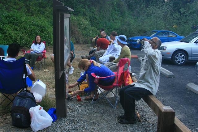
People were soon rolling in. The times were quite similar to our previous visit, with David filling in Peter's role this year. The big surprise was that 70% did the bonus three peaks. Everyone happily ate whatever food was within reach of their weary limbs. Sabine cooked up her traditional (for this hike) chili, which hit the spot as always. Speaking of tradition, the discussion broke out about whether it was a 5 or a 6. Last year I was pretty neutral, but this time it was easier to make it a six--it was hotter.
Side story: As we were unloading outside the still-closed Wildcat parking area in the morning, a yellow car pulled up and dropped off one lone hiker. We later passed him, figuring he was going to Inspiration Point, or somewhere similarly lame. At the end of the hike, several people recognized the same yellow car in the Proctor parking lot. That was a good observation, as the guy (and the woman who dropped him off) showed up a bit before David. He had taken the West Ridge instead of French, and his girlfriend had hiked up from Proctor to meet him in the opposite direction. Who knew the hike was so popular?
Hike started at 6:57am.
| Hikers | Finish(pm) | Hike Time |
|---|---|---|
| Ross* | 3:42 | 8:45 |
| Steve* | 3:53 | 8:56 |
| Diane M | 4:51 | 9:54 |
| George*, Linda L | 4:56 | 9:59 |
| Eugene M*, Helen* | 5:10 | 10:13 |
| Nani*, Sabine*, Sarah*, Silviu | 5:15 | 10:18 |
| Cecilia, Harvey* | 5:23 | 10:26 |
| Eric F*, Iyad*, Gladys | 6:01 | 11:04 |
| David* | 7:24 | 12:27 |
* Did the "extra credit" of visiting Wildcat, Vollmer, and Round Top peaks.
Milestones:
Cecilia's 1st leaf
Eugene M's 10th leaf
Gladys's 10th leaf
Linda L's 50th leaf
![]()
![]()
Pages maintained by Steve Walstra,
Peter Saviz, and
Russell Gee.
©2026 Intrepid Northern California Hikers