
| Main Page | Diary | Leaves | Stats |

565. Mustang Peak (05/20/07)
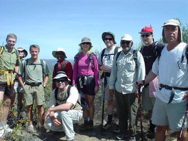
Hikers (22): Clive, David, Diane, George, Helen, Hima, Janice, Linda L, Nani, Paul, Peter, Peter M, Ramesh, Ross, Rudi, Russ, Sabine, Scott, Stacy, Steve, Walter, Wennie
Distance: 22 miles
Rating: 5 difficulty, 9 beauty
Park info: Henry Coe State Park near Hollister
Write-up by Steve -- Pictures by Stacy and Janice
It was a special day for hardcore hikers in the Bay Area: Henry Coe State Park was opening a new entrance (Dowdy Ranch) with much fanfare. Despite Coe's long distance from the Bay Area, this is INCH's most visited park thanks to its variety of epic hike opportunities. With a new entrance, we now have even more options! So we made haste to say "Howdy Dowdy", visiting on the second day it was open.
As it turned out, JP finished a multi-day hike ending at Dowdy the day before (Saturday), garnering some fame in the process. But one day later at 10am, you'd think the park had never opened, as INCH owned nearly all the cars in the lot. I had planned a loop to visit three peaks in the park, with remote Mustang Peak being the main goal. As we were getting ready, one of the rangers (Cameron) came out and asked for me by name. He made some small talk, and then mentioned that groups our size needed to have permits, available at the headquarters (many miles away). This was a surprise, but a few weeks prior someone had said a ranger at Castle Rock State Park had also mentioned something about a group permit. As I tried to backpedal/negotiate out of this, he said "JP told me to say that." Everyone got a good laugh.
He also told us that there was cell phone coverage on Burra Burra and Mustang Peaks if we needed to call for help. We assured him we'd do our best not to use their services. We also learned (from a previous discussion) that the hardest part of the proposed route was coming back up to the visitor center (yep, just like on the HQ-side of Coe). Of the many trails we were taking, the only one they didn't have any information on was Walsh Trail, meaning everything else looked good.
With all that fine information, we were ready to go: 1-2-3 INCH!
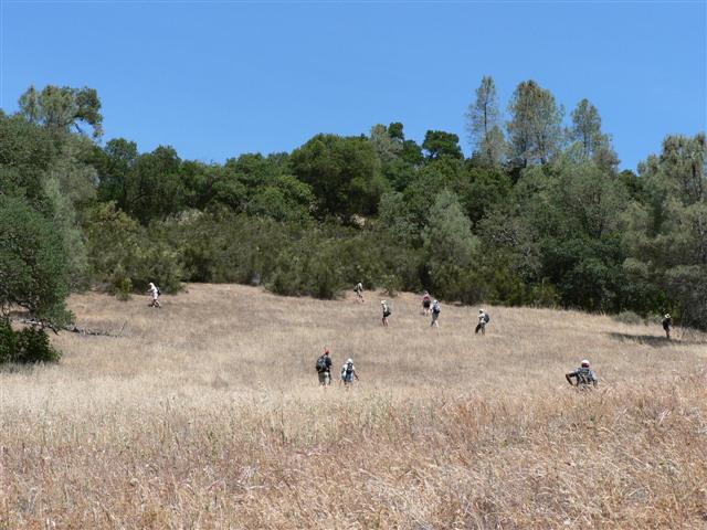
We looped behind the visitor center on an unnamed trail and hit the road for a tenth of a mile (where we passed the only two hikers we'd see all day) to pick up the Burra Burra Trail. The route was highlighted on copies of Bill Levey's old line maps that are still great many years later. I don't know the guy, but I owe him many beers for all times I've used those maps (now lovingly overlaid on Google Earth). This is the same map that had me lead two different INCH hikes down the long abandoned Drift Fence Trail, too. Ah, good times. . .this time, though, all the trails we took actually existed. Mostly.
We bagged Burra Burra peak in short order--not much room on top, so we sort of visited it in groups. From there, it was down Center Flats Road to Walsh Trail. Although the trail marker was clear, Walsh Trail appeared to be virtually unused. I decided to wait a few yards down the faint trail to flag everyone else in. Surprisingly, the front runners waited for a while as well (which lets you know how faint the trail really was). Eventually, though, as more people showed up, I heard a "Take a left when you get back here, Steve" as the group left.
I waited until Russ showed up, and he said he'd wait for Hima and Peter M, who weren't far behind. I headed back, ignored the left (and the nice arrow) and poked around a bit looking for a different route. Came to the same conclusion as everyone else and finally took the suggested left. This trail disappeared quickly, and as I went down a hill, I could see people fanned out on the next ridge. By the time I walked down into the valley and up to the top of the nearest ridge, everyone had found the trail (which was, luckily, the same ridge). I took the re-discovered trail in the opposite direction, which led to several fallen trees. These trees were blocking the nice, straight trail that we should have taken instead of "going left". I returned to the ridge and waited again for Russ and crew, because this would be a bad place to get lost. It wasn't too long until they showed up, and we were all on the trail--from here there was a clear jeep road for a long while. . .
. . .which ended in deep valley (Pacheco Creek) near a little metal hut. There was a trail up the side of the hill somewhat, but that petered out. Looking on the hillside, there were three groups searching unsuccessfully for the trail. Since they hadn't found it yet, I decided to do some reconnaissance farther down the creek. That didn't work too well, as the trail along the creek disappeared. Rather than turn around, however, I decided to just head up a gully. This resulted in a 40-minute serious bushwhack with lots of steep terrain and (often unsuccessful) elephanting through chaparral. The process was made worse by the fact that I had forgotten my hiking boots, which forced me to hang on brush for dear life as my tennis shoes weren't holding the ground very well.
When I finally approached the top of the ridge, the bushes disappeared for the last 5 yards and--surprise!--I was at the official junction of Walsh Trail with Pachecho Ridge Road. No one was visible in either direction--was I the only one to make it here, or had everyone long since found the trail and gone on? Guess I'd find out at Mustang Peak. Onward!
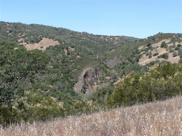
Pachecho Ridge was nice, with good views of the west side of the park, plus a bonus shot of the rock formations behind Pacheco Falls, which we had visited a few months prior. After a while, I caught sight of Hima, so realized that everyone had found the trail. In fact, it turned out that everyone came out of the correct Walsh exit, thus confirming that I had taken the dumbest possible route.
The front of the pack stopped at a five-way junction near the end of Turkey Pond Trail, where eventually (almost) all of us re-grouped. I dropped a big arrow here and headed up the hill a little early to snag a geocache two miles down the trail. As I was looking for it, Ross zoomed by. As I was logging it, Sabine and Helen zoomed by. By the time I got to the bottom of Mustang Peak, I had just caught Sabine and Helen, and Ross was up on top (no doubt for a while). Helen and Sabine took the steep use trail up.
I kept going down the fire road to see if there was another way up. On a gate post, someone had written "Mustang Peak" with an arrow pointing up along a fence line. I said, "That can't be the trail" and kept going around the corner, where I eventually found a jeep trail going up (along with an unexpected wooden sign proclaiming "Mustang Canyon"). Later, George told me that the "Mustang Peak" arrow was left by JP (and was indicating "around the corner", rather than "up here"). It clearly said "JP" and the date underneath, but never crossed my mind at the time that it was a message. Diane M was the only other person to head around the backside, but she missed the uphill trail and went off route for a while before figuring it out.
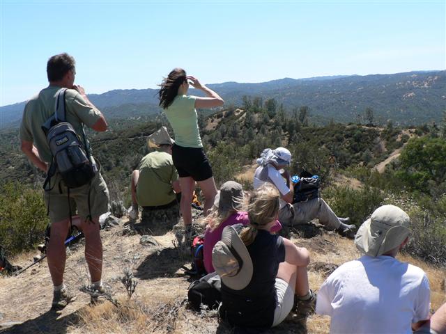
Eventually, everyone made it. Hooray--100% success--it's all downhill from here {except that little section near the end}. Most of us waited at the top for a while, but of course "most" exempts Sabine and Helen, who are always much too busy to wait--they took off early. But that day was a good day to wait and enjoy the nice breeze blowing. Eventually the party at the peak broke up and we were on our way. Some people took the longer-but-gentler backside route down, and others took the steeper way down.
A few long miles later it was time for a left down Dutch's Trail. There was a big blue container here, full of water (we assume). Several people considered snagging a little, but we didn't actually know for sure it was potable. Was it left by the Park Service or the Peoples Temple? A discussion later with a Coe volunteer said it was not from the park service, so must have been left by some other organization. Mysterious. . .it was the second one we'd seen that day.
The next three or four miles down to Tie Down Peak featured a couple of potential side trails on the map, but in practice there was only one route (the others were both difficult to see and unsigned). As I came around the corner along Tie Down, I ran into Rudi who was sitting down eating a sandwich. I said, "Hey, Rudi, did you know that's Tie Down Peak?" He claimed not to know, and we both decided not to do it since there didn't appear to be any obvious trails (and I was low on water). As I moved on, however, I saw Peter, Nani, and Stacy coming down. I said, "Did you make it to the top?" "No, too steep and rocky." Good enough for me!
Ross had also tried to find a path up, but ran into the same impasse as Peter et al.. George, however, made it up. So did (we would learn much later) Helen and Sabine. Most of the other people didn't try or didn't even know it was Tie Down Peak since it doesn't look as obvious (nor as rocky) from the side we approached compared to the view from Burra Burra.
The trail pretty much kept going down now. It should have been easy, but every time I took a draw of water, I was sure it would be the last one. I was looking eagerly for one of those fishy blue boxes. My water held out until the last couple miles, but psychologically, it had run out at Tie Down, so I'd been hiking cautiously.
When we got to the North Fork Trail, I knew the hike was almost over (in as much as 2.5 miles and 1000 ft is "almost over"). Several people had passed me on the way down, but because I had been anticipating this junction for miles, I zipped right by while Stacy and crew were checking out their maps. From there, it was mostly flat (and covered in orange flags) until the last uphill portion on the Max Corral Trail. The trail starts out steep, but once you finally get near the top (and can just see the edge of the picnic area), it enters a series of long, shallow switchbacks, delaying the much anticipated conclusion. Big Henry always finds new ways to demoralize visitors.
When I got to the top, only Ross was there. I didn't understand how this could be since Helen, Sabine, and George should have been there already for sure. Even worse, my carpool was far, far away and I hadn't gotten a key, so couldn't change. However, solace was to be found in the pristine bathrooms, which featured nice sinks in which to clean up.
As already mentioned, George, Sabine, and Helen were missing because they had made it up to Tie Down peak. Helen and Sabine (with a GPS, no less) got lost coming down from Tie Down, and ultimately went cross-country to pick up the very visible Kaiser Aetna Road. Whoops! But it made for a good adventure.
Eventually everyone else rolled in, and we started eating in earnest. Everything tasted fantastic after the long hike. The grill was hot and a round of sausages were getting started when a ranger informed us it was time to skedaddle. Several people attempted to negotiate, but ultimately we started cleaning things up and scarfed down the sausages in a timely manner--all in all, it worked out pretty well.
With Mustang Peak out of the way, what else can we visit from the new entrance? Stay tuned!
Milestones:
David's 1st forest
Hima's 1st forest
Linda L's 40th leaf
![]()
![]()
Pages maintained by Steve Walstra,
Peter Saviz, and
Russell Gee.
©2026 Intrepid Northern California Hikers