
| Main Page | Diary | Leaves | Stats |

319. Skyline-to-the-Sea Trail (05/24/03)
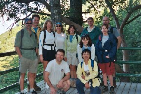
Hikers (12): Blinky, Cathy, Dave M, Janice, Julie M, Laurie, Mark M, Nancy, Padraig, Peter, Steve, Taylor
Distance: 32 miles
Rating: 5 difficulty, 9 beauty
Park info: Castle Rock State Park in the Santa Cruz Mountains
Write-up by Peter and Steve -- Pictures by Janice
This classic trail covers 31 miles starting from Castle Rock State Park on Skyline Blvd, heading southwest to Waddell Beach between Santa Cruz and Half Moon Bay on the Pacific Ocean (the Sea!). Each section of the trail is considered a Level 2 hike when done by itself, but because we planned to do it all in one day, we rated it a Level 5.
I had sent out email earlier in the week detailing some of the difficulties of this hike, but 11 other fools decided they wanted to go regardless! People were starting to take bets on how many would actually complete the trail ...
Pre-work: Beth, Cathy, Padraig, Taylor, and myself met at the unholy hour of 5:00 am to drive down to the beach and leave some cars there for post-hike ride back. Surprisingly, everyone was on time and in excellent spirits! We wasted no time and hit the road. I was driving the new (actually, old) INCH wagon and had my doubts as to whether it would actually be able to go that far, but it did not let me down. We drove through the morning mist down Hwy 17 and up Hwy 1 to the beach. It was windy and cold as we got to the beach and the waves were crashing against the shore - very refreshing! We dropped off the other cars and then piled into the INCH wagon and headed back up the hill to Castle Rock to meet the others.
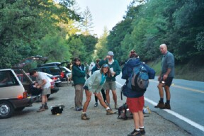
We got there a couple of minutes after 7 o'clock, and everyone was assembled and rarin' to go. Without further ado, we welcomed the newbies and hit the trail!
1, 2, 3, ... INCH!
1st Leg (~3 miles; 1 hour): From Castle Rock entrance, we headed to the Trail Camp on the western edge of the park. This was the same trail we had done a month earlier on
Rusty's sabbatical farewell hike.
We made a brief stop for a photo at the falls, and then continued on. As we went along, we admired the views of Big Basin from a distance (the parts that were not covered by morning fog).
2nd leg (~3 miles; 1 hour): From the Trail Camp, we took the Saratoga Gap Trail down the hill. This is where we had taken a wrong turn and walked an extra mile on
our last trip, and guess what -- we made the exact same mistake again!!!
Note to self: Next time, don't take the Saratoga Gap Trail ... take the
Frog Flat Trail down to the Frog Flat Camp ... repeat that 100 times so you don't forget it! After Frog Flat, the trail continued along a fire road, then through a gate and along a paved road with houses on both sides. By now, Steve had gotten separated from us and was off geocaching, so I could not confirm that this was the right trail. I didn't remember this part at all. We continued on, following the trail signs and ignoring all the barking dogs that we had woken up. Finally, after about a mile we saw a small hikers-only trail on the left marked “Saratoga Gap”. We took this trail and it in less than half a mile, it connected up with the Skyline-to-the-Sea Trail. One thing I have to say about this trail is that the first few miles are not well-marked, but after that it's smooth sailing.
3rd leg (~4 miles; 2 hours): The next section of the trail ran along Hwy 9, criss-crossing back and forth across the road a couple of times. About 1.5 miles down the road, we took a 10-minute break at Sempervirens Point (the meeting place for the exclusive
Myers Trail
hike), and enjoyed the view. From here, it was a quick 2.5 more miles to Waterman Gap – probably the easiest stretch of trail in the whole hike, which allowed us to make up for some lost time. We took a 20-minute break at Waterman Gap trail camp. We were close to being one-third of the way through the hike, and it was starting to take it's toll -- people were taking off their shoes and rubbing their feet. Laurie's feet had started to blister up pretty good. I didn't think she'd be able to make it all the way.
4th leg (~5 miles; 2 hours): The trail crossed over Hwy 9 and went along Hwy 236 towards Big Basin. We were now starting to get spread out. I was in the front group with Padraig, Janice, Nancy, and Taylor. Beth, Laurie, and the Meador clan (Cathy, Dave, Julie, and Mark) were bringing up the rear. I urged the group to hike faster, otherwise we would not make it to the beach before dark. There were rumblings of discontent, but the group picked up the pace. We continued on, making good time and not making any more stops. The trail eventually broke away from Hwy 236 and headed uphill to China Grade Road.
5th leg (~5 miles; 2 hours): We crossed China Grade Road and picked up the trail on the other side. We were now at the half-way point of the entire hike. The scenery changed quite dramatically at this point – no more giant redwoods to provide shade, but plenty of manzanita, open skies, and Yosemite-like exposed granite rocks. The rocky trail was not very forgiving on the feet, ankles, and knees, but we pressed on. Eventually, the trail led back down through the redwoods and along the creek to Big Basin Park Headquarters (where we encountered hundreds of loud tourists along the way!).
We arrived at Big Basin at exactly 3 o'clock and stopped to rest for half an hour. Janice had been hobbling pretty good for the last hour, and Padraig performed some minor surgery on her blistered toes as we watched and ate lunch. Great entertainment! Nancy was doing great -- I had been worried about her ability to do this hike, but she was proving me wrong. Good for her! No sign of either Steve or the second group of hikers.
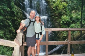
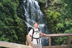
6th leg (~6 miles; 2 hours): After a good rest, we continued on the Skyline-to-the-Sea Trail through the giant redwoods to Berry Creek Falls. I told Nancy to ignore the sign that says it is a strenuous trail – that sign is for common mortals, not INCHers! The rest had done us good -- we were kicking ass on this stretch and made it all the way to the falls without any stops. I felt much less tired than I did the last time I did this hike. Janice was doing great too, despite her aching feet. Good job all around! We sat on the bench across from the falls, and enjoyed some snacks (thanks Candyman!) while taking in the gorgeous view. After that we took the trail to the platform directly facing the falls up for a couple of quick photos.
While we were there, we heard voices calling us -- the second group had caught up! Excellent job all around! The only casualty was Laurie, who had stopped at Big Basin. Her blisters had not allowed her to continue, but she still gets high marks for making a gallant effort.
7th leg (~5 miles; 2 hours): The home stretch! From the platform facing Berry Creek Falls, we backtracked down the trail a short distance, and turn right onto the trail heading towards Waddell Beach. From here on out, it was just walking on a flat, wide trail that runs along Waddell Creek all the way to the beach. Taylor and Nancy were practically running at this point! Even I had some energy left to burn, so I intended to take the challenging “Hikers Only” trail for the last mile, but the bridge was washed out so I was thwarted and had to continue on the same trail (marked “Bikers, Equestrians, and Handicapped”). At least it gave me a chance to see something different, including the mighty Eagle Tree. About half a mile from the end, we saw Esty walking towards us. He had taken a different (shorter!) trail from Castle Rock and had hooked up with the Skyline-to-the-Sea further down, but then had taken the Ridge Trail instead of going to Berry Creek Falls. That's a good trail too, but it's no Skyline-to-the-Sea! Either way, he had done 30+ miles, so I guess we can give him a leaf.
It's over! 32 miles and 80,000 steps later, we crossed Hwy 1, peeled off our hiking boots, and chugged some well-deserved cold beer while enjoying the beautiful view of the Pacific Ocean! Aaaaaahhhhh!!!!! An excellent finish to an excellent hike!
Steve's Story:
I started to take my own sweet time once I realized I was in the lead. At Big Basin HQ, I got slightly lost and ended up on the Redwood Trail loop, a half-mile trail which traps visitors into a tight meandering loop. One cool aspect of the trail is that it passes the two largest redwoods in the park (the "Mother" and "Father" of the Forest)--never knew they were there.
From the HQ, took the McCrary Ridge Trail rather than the STTS trail. Having hiked the STTS trail before, it seemed like a good time for something new (oh, and there were a couple caches along that route). Unlike the STTS trail, the ridge trail goes up to the Mt.McAbee Overlook instead of down along Waddell Creek. From there, one gets great views all around, including the ocean (still far, far away). Hiking along the ridge seemed to be much better (and a little breezier) than my memories of the STTS trail. I would strongly recommend this route next time, if for any reason than being able to see the goal sooner.
Whatever the case, eventually the ridge trail takes you back down to STTS trail again, and the rest was unremarkable. The hiker's trail near the end of the hike (that Peter and I regretted taking last time) was unaccessible this year--the bridge had washed out. That provided a convenient excuse for taking the flat road all the way to the beach. After recuperating for an hour or so, I finally had to hike back into the park to keep from freezing on the windy beach. By then, I was getting a little worried that something tragic had happened, but it wasn't too long until I ran into the first of the group, and everything ended as Peter described.
Milestones:
Janice and Padraig are not even tired!
Peter's happy that it's almost over ...
During the 1st leg, I went off to find a geocache. Afterwards, I hiked quickly to catch up with everyone else. There is a branch in the trail that goes either southwest (toward The Sea!) or N (away from The Sea). I took the logical SW trail, while (as you would guess) everyone else headed North to the actual start of the Skyline-To-The-Sea (STTS) trail. Although this makes it a true hike of the full STTS trail, it probably isn't what the Castle Rock sign intended at the entrance (since it leaves Castle Rock park).
Julie M's 1st leaf
Mark M's 1st leaf
![]()
![]()
Pages maintained by Steve Walstra,
Peter Saviz, and
Russell Gee.
©2026 Intrepid Northern California Hikers