
| Main Page | Diary | Leaves | Stats |

1036. Tiedown and Walsh Peaks (05/21/16)
Hikers (14): Bill M, Brad, Chinyet, Christina, Christophe, Giulia, Jane, Jeff, Jim, Peter M, Sarbinder, Shuli, Sophie, Steve
Distance: 17 miles
Rating: 4 difficulty, 7 beauty
Park info: Henry Coe State Park near Bell Station
Write-up by Steve -- Pictures by Chinyet
I skipped hike #1033 to spend the weekend in Henry Coe for Backcountry Weekend. During planning for that trip, I ran across a story about a trail crew clearing the route to Walsh Peak the previous year. I decided to come back and visit Walsh Peak once Dowdy Ranch opened up. . .which happened immediately after Backcountry Weekend.
The combination of rain and poison-oaky off-trail hiking should have scared people off, and it mostly did, with a very reasonable count of 15 people signing up. Even better, the rain prediction dropped just before the hike.
1-2-3 INCH!
To kick things off, I led everyone to the first destination just behind Dowdy Ranch: Seven Oaks Peak (it lived up to its name). This was the first "baby cross country" of the hike, and everyone missed it, despite me waving from the summit. Eventually everyone slogged through the high grass to the this summit. From there, we went down an established use trail, across the road, and up the signed trail to Burra Burra peak.
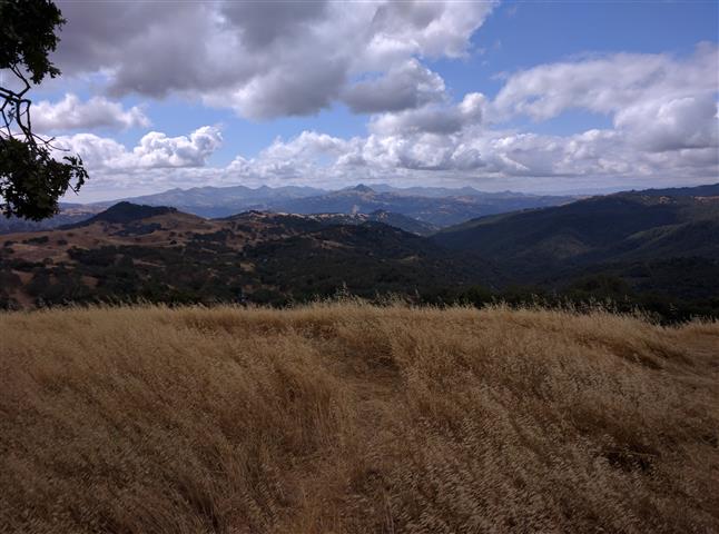
This route had seen plenty of use during Backcountry Weekend, so the trail was easy to follow, yet was still just a narrow path through tall grass for most of the way. We waited at the summit for everyone to arrive. We could see (at certain points) the next goal: Tiedown Peak (or Tie Down Peak, depending on how you want to spell it).
We headed down, and I eventually caught up to the front of the pack to slow them down. We had to genuinely go cross country at some point, so eventually held everyone up along Tiedown Trail so we could start together.
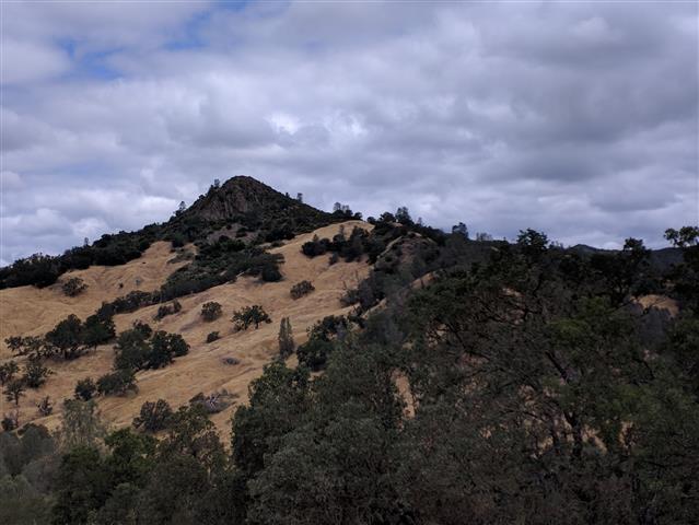
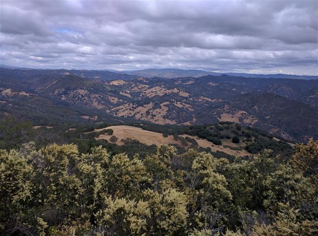
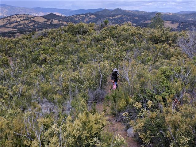
I had read plenty of failed and successful attempts at this peak, and the consensus was the best route was from the East, which is rocky, but doesn't require so much pushing through chaparral. So that's the route we took. . .and it worked out just fine, with a steep Class 3 scramble to get to the stop. I went a bit too high, too soon, at the start, so had to cut back down to avoid the bulk of the foliage and poison oak.
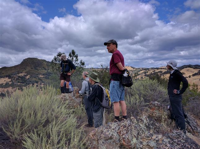
From the start of the hike (via Seven Oaks Peak and Burra Burra), it took about 1 hour, 40 minutes to get to the summit. The bulk of the group was there soon after. However, it was another hour until Shuli finally made it to the summit. Instead of taking the route most of us took, she opted for the slightly sleeper/blockier route along with Bill, Jeff, and Jim. . .The only upside of the route they took was that Bill declared he was at a point higher than where we were sitting--which seemed to be correct. Getting from the point we breached the summit to where they came up required a minor bushwhack. There was a geocache and a summit registry, so people definitely visit the summit, but if there is a use trail anywhere, we never saw it.
But while Shuli made us wait, she did make it. Sarbinder, on the other hand, made two attempts to get to the summit, but failed, so earned his first second Black Leaf of Shame. Luckily, we guessed he might not make it, so didn't wait any longer. . .
Jane O and Brad refused to wait for Shuli, much to my great annoyance since they had no idea how to get to the next peak. I found them (along with Jackie) not too far from where came out on the Kaiser-Aetna Road. We had taken a different route down, deciding that it would be unpleasant going down the steep way. And that was mostly correct--it wasn't too bad. Christophe managed to separate from the group on the way down from Tiedown, never to be seen until the end of the hike (but he did all the peaks).
The route up to Walsh was flagged, and Sarbinder was the first to point out the ribbons showing the start of the route. Presumably many people hiked up there a few weeks ago, but we lost the trail at the start and picked it up again higher on the ridge. Jackie, who barely even tried Tiedown, bailed on Walsh almost immediately (thinking it was another Tie Down!), so got a Pink Leaf of Weakness. . .
Once we were on the trail, it got progressively easier to follow. The route ultimately led right to the summit, and Chinyet, Jane, and Sarbinder blew by on the slog up. The summit features an unambiguous summit block. Hooray! From there, we followed Walsh Ridge all the way to County Road, and took Tiedown Trail back.

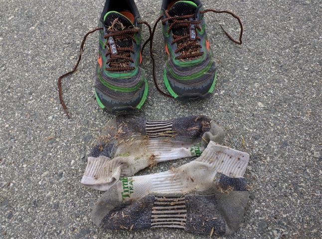
Along Tiedown, I was really hurting. Because there was a chance of rain, I wore my "rain" boots. Those boots had been sitting on my patio for months since the last rain. Apparently they'd shrunk, and were wearing the skin off my feet and ankles in no fewer than five locations. I finally stopped along the route (to get a geocache) and took off my boots. I could tell from the crimson color of my socks that the damage was already done. And, much to my dismay, I'd left my first aid kit in the car. . .
An old trail connects Tiedown Trail to Yellowjacket Trail along a ridge. It's one of the few trails in the area I'd never taken, so made it a detour for this hike. I had the waypoint, as I was thinking it would be something obscure. Instead, it was one of those funny Coe junctions where the signs point to every direction except the trail you are going to take. That usually indicates they are going to close the trail eventually (an old example of this is Drift Fence Trail). The route was again flagged (for BCW) and had clearly enjoyed some visitation during BCW. On the other end of the trail was a junction marker which, again, failed to indicate the trail used to reach it. So next time you see a sign in Coe for "no reason". . .there's probably an old trail there.
Normally the climb up Mack's Corral seems overly switch-backed near the end, but I loved it on this hike. My feet were killing me, and the uphills were the only reprieve from the pain. I stopped at a nice-flowing spring near the end and wiped off all the chaparral grime and salt. Felt like a million bucks when I got to the top. Went back to the car and triaged my wounds (it was a three band-aid hike). That was followed by some liquid painkiller, and everything was OK. . .until Sunday, Monday, and Tuesday (when I'm writing this).
Milestones:
Chinyet's 90th leaf
Steve's 810th leaf
![]()
![]()
Pages maintained by Steve Walstra,
Peter Saviz, and
Russell Gee.
©2026 Intrepid Northern California Hikers